
FCCInfo.com
A Service of Cavell, Mertz & Associates, Inc.
(855) FCC-INFO
|
|
W285GB from 01/08/2018 |
|
|
||||||||||||||||
|
|
W285GB Channel: 285D 104.9 MHz Russellville, Kentucky Service: FX - A translator or application for a translator. Facility ID: 201335 Fac. Service: FX Programming Delivery Method: Unspecified Status: License Application Accepted: 11/08/2019 Application Granted: 02/19/2020 File Number: -0000088487 License Expires: 08/01/2020 Application Type: License To Cover FCC Website Links: LMS Facility Details This Application Other W285GB Applications Other W285GB Applications in CDBS Including Superseded Applications Mailing Address Correspondence for W285GB Correspondence related to application -0000088487 Service Contour - Open Street Map or USGS Map (60 dBu) Service Contour - KML / Google Earth (60 dBu) Facility Type: FM STATION Class: D, A Noncommercial educational operating with no more than 10W Site Location: 36-50-41.1 N 86-55-21.0 W (NAD 83) Site Location: 36-50-40.9 N 86-55-21.0 W (Converted to NAD 27) Effective Radiated Power: 0.235 kW Antenna Center HAAT: 0 m Antenna Center AMSL: 383 m (1257 ft.) Antenna Center HAG: 180 m (591 ft.) Site Elevation: 203 m. (666 ft.) Height Overall*: 183 m (600 ft.) (* As Filed In This Application, may differ from ASR Data, Below.) Directional Antenna Antenna Make/Model: Nicom BKG77-2 Antenna ID: 135245 Polarization: H
| ||||||||||||||||||
| Antenna Data for Antenna Id: 135245 W285GB FX File: -0000088487 Nicom - BKG77-2 Service: FX | 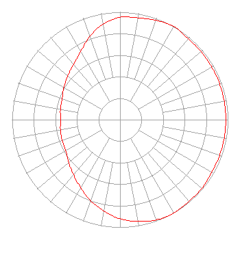 | ||||||||||||||||||
| Azimuth | Ratio | Azimuth | Ratio | Azimuth | Ratio | Azimuth | Ratio | ||||||||||||
| 0 | 0.950 | 10 | 0.960 | 20 | 0.980 | 30 | 1.000 | ||||||||||||
| 40 | 0.980 | 50 | 0.980 | 60 | 0.980 | 70 | 0.980 | ||||||||||||
| 80 | 0.980 | 90 | 0.980 | 100 | 0.980 | 110 | 0.980 | ||||||||||||
| 120 | 0.980 | 130 | 0.990 | 140 | 0.990 | 150 | 1.000 | ||||||||||||
| 160 | 0.990 | 170 | 0.960 | 180 | 0.920 | 190 | 0.860 | ||||||||||||
| 200 | 0.800 | 210 | 0.730 | 220 | 0.670 | 230 | 0.620 | ||||||||||||
| 240 | 0.580 | 250 | 0.570 | 260 | 0.560 | 270 | 0.550 | ||||||||||||
| 280 | 0.560 | 290 | 0.570 | 300 | 0.600 | 310 | 0.630 | ||||||||||||
| 320 | 0.670 | 330 | 0.730 | 340 | 0.820 | 350 | 0.900 | ||||||||||||
Structure Registration Number 1043269 Structure Type: GTOWER Registered To: LOGAN RADIO INC Structure Address: 1063 Highland Lick Rd Russellville, KY County Name: Logan County ASR Issued: 03/02/2021 Date Built: 03/05/2021 Site Elevation: 203 m (666 ft.) Structure Height: 182 m (597 ft.) Height Overall: 183 m (600 ft.) Overall Height AMSL: 386 m (1266 ft.) FAA Determination: 03/01/2021 FAA Study #: 2021-ASO-3147-OE FAA Circular #: 70/7460-1M Paint & Light FAA Chapters: 3, 4, 5, 15 PRIOR STUDY 1996-ASO-3665-OE 36-50-41.0 N 86-55-21.0 W (NAD 83) 36-50-40.8 N 86-55-21.0 W (Converted to NAD 27) |
1601 Nashville Street Russellville, KY 42276 Phone: 270-726-2471 Corporation | Title: President Date: 11/08/2019 Application Certifier LOGAN RADIO INC. Logan Radio Inc. 1601 Nashville Street Russellville, KY 42276 Applicant Allan G Moskowitz, Esq. Allan G. Moskowitz, Esq. 10845 Tuckahoe Way North Potomac, MD 20878 Carl E Gluck Carl T. Jones Corp Carl Gluck C/o Carl T Jones Corp 7901 Yarnwood Court Springfield, VA 22153 TECHNICAL CONSULTANT | |||||||||||||||||