
FCCInfo.com
A Service of Cavell, Mertz & Associates, Inc.
(855) FCC-INFO
|
|
W281BR from 04/17/2013 W281BR from 03/31/2011 W281BR from 11/02/2010 W281BR from 08/08/2008 W281BR from 07/22/1998 W281BR from 07/20/1998 |
|
|
||||||||||||||||
|
|
W281BR Channel: 281D 104.1 MHz Memphis, Tennessee Service: FX - A translator or application for a translator. Facility ID: 89003 Fac. Service: FX Programming Delivery Method: Unspecified Status: License Application Accepted: 12/13/2019 Application Granted: 02/19/2020 File Number: -0000093310 License Expires: 08/01/2020 Application Type: License To Cover FCC Website Links: LMS Facility Details This Application Other W281BR Applications Other W281BR Applications in CDBS Including Superseded Applications Mailing Address Correspondence for W281BR Correspondence related to application -0000093310 Service Contour - Open Street Map or USGS Map (60 dBu) Service Contour - KML / Google Earth (60 dBu) Facility Type: FM STATION Class: D, A Noncommercial educational operating with no more than 10W Site Location: 35-12-34.3 N 89-49-01.3 W (NAD 83) Site Location: 35-12-34.0 N 89-49-01.0 W (Converted to NAD 27) Effective Radiated Power: 0.25 kW Antenna Center HAAT: 0 m Antenna Center AMSL: 298 m (978 ft.) Antenna Center HAG: 214 m (702 ft.) Site Elevation: 84 m. (276 ft.) Height Overall*: 280 m (919 ft.) (* As Filed In This Application, may differ from ASR Data, Below.) Directional Antenna Antenna Make/Model: Scala 2xCA2-FM/CP/CV Array Antenna ID: 134639 Polarization: H
| ||||||||||||||||||
| Antenna Data for Antenna Id: 134639 W281BR FX File: -0000093310 Scala - 2xCA2-FM/CP/CV Array Service: FX | 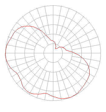 | ||||||||||||||||||
| Azimuth | Ratio | Azimuth | Ratio | Azimuth | Ratio | Azimuth | Ratio | ||||||||||||
| 0 | 0.253 | 10 | 0.223 | 20 | 0.166 | 30 | 0.109 | ||||||||||||
| 33 | 0.108 | 40 | 0.123 | 50 | 0.193 | 60 | 0.237 | ||||||||||||
| 70 | 0.263 | 80 | 0.299 | 90 | 0.451 | 100 | 0.634 | ||||||||||||
| 110 | 0.784 | 120 | 0.884 | 130 | 0.919 | 140 | 0.951 | ||||||||||||
| 150 | 0.990 | 159 | 1.000 | 160 | 0.997 | 170 | 0.971 | ||||||||||||
| 180 | 0.910 | 190 | 0.862 | 200 | 0.919 | 210 | 0.967 | ||||||||||||
| 220 | 0.951 | 230 | 0.886 | 240 | 0.869 | 250 | 0.937 | ||||||||||||
| 260 | 0.983 | 267 | 1.000 | 270 | 0.996 | 280 | 0.976 | ||||||||||||
| 290 | 0.932 | 300 | 0.912 | 310 | 0.850 | 320 | 0.731 | ||||||||||||
| 330 | 0.562 | 340 | 0.378 | 350 | 0.277 | ||||||||||||||
Structure Registration Number 1249321 [ASR Heights Differ from W281BR Application] Structure Type: Registered To: RADIANT LIFE MINISTRIES. INC. Structure Address: 3145 Bartlett Corp Drive Bartlett, TN County Name: Shelby County ASR Issued: 06/10/2021 Date Built: 04/01/2008 Site Elevation: 84.4 m (277 ft.) Structure Height: 274.3 m (900 ft.) Height Overall: 275.8 m (905 ft.) Overall Height AMSL: 360.2 m (1182 ft.) FAA Determination: 04/19/2005 FAA Study #: 2005-ASO-139-OE FAA Circular #: 70/7460-1K Paint & Light FAA Chapters: 3, 4, 5, 12 Removed expiration and final dates from determination. Scenario 2./jjs/case#635066 35-12-34.3 N 89-49-01.4 W (NAD 83) 35-12-34.0 N 89-49-01.1 W (Converted to NAD 27) |
6080 Mount Moriah Ext. Memphis, TN 38115 Phone: 901-375-9324 Corporation | Title: President Date: 12/13/2019 Application Certifier ARLINGTON BROADCASTING COMPANY Arlington Broadcasting Company 6080 Mt. Moriah Ext. Memphis, TN 38115 Applicant William Jeffrey Reynolds Du Treil, Lundin & Rackley, Inc. 3135 Southgate Circle Sarasota, FL 34239-5515 Technical Consultant Stephen C Simpson Attorney At Law 1250 Connecticut Avenue, Nw Suite 700 Washington, DC 20036 | |||||||||||||||||