
FCCInfo.com
A Service of Cavell, Mertz & Associates, Inc.
(855) FCC-INFO
|
|
W284CQ from 10/06/2014 W284CQ from 06/28/2011 W284CQ from 04/27/2011 |
|
|
||||||||||||||||
|
|
W284CQ Channel: 284D 104.7 MHz Washington, District of Columbia Service: FX - A translator or application for a translator. Facility ID: 31140 Fac. Service: FX Programming Delivery Method: Unspecified Status: License Application Accepted: 01/15/2020 Application Granted: 01/22/2020 File Number: -0000097616 License Expires: 10/01/2027 Application Type: License To Cover FCC Website Links: LMS Facility Details This Application Other W284CQ Applications Other W284CQ Applications in CDBS Including Superseded Applications Mailing Address Correspondence for W284CQ Correspondence related to application -0000097616 Service Contour - Open Street Map or USGS Map (60 dBu) Service Contour - KML / Google Earth (60 dBu) Facility Type: FM STATION Class: D, A Noncommercial educational operating with no more than 10W Site Location: 38-53-30.0 N 77-07-54.0 W (NAD 83) Site Location: 38-53-29.6 N 77-07-55.1 W (Converted to NAD 27) Effective Radiated Power: 0.099 kW Antenna Center HAAT: 0 m Antenna Center AMSL: 218 m (715 ft.) Antenna Center HAG: 105 m (344 ft.) Site Elevation: 113 m. (371 ft.) Height Overall*: 151 m (495 ft.) (* As Filed In This Application, may differ from ASR Data, Below.) Directional Antenna Antenna Make/Model: Electronics Research Inc. 100A-2F-DA-HW Antenna ID: 133562 Polarization: H
| ||||||||||||||||||
| Antenna Data for Antenna Id: 133562 W284CQ FX File: -0000097616 Electronics Research Inc. - 100A-2F-DA-HW Service: FX | 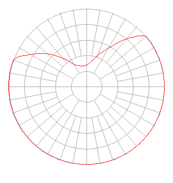 | ||||||||||||||||||
| Azimuth | Ratio | Azimuth | Ratio | Azimuth | Ratio | Azimuth | Ratio | ||||||||||||
| 0 | 0.276 | 10 | 0.319 | 20 | 0.427 | 30 | 0.573 | ||||||||||||
| 40 | 0.795 | 50 | 1.000 | 60 | 1.000 | 70 | 1.000 | ||||||||||||
| 80 | 1.000 | 90 | 1.000 | 100 | 1.000 | 110 | 1.000 | ||||||||||||
| 120 | 1.000 | 130 | 1.000 | 140 | 1.000 | 150 | 1.000 | ||||||||||||
| 160 | 1.000 | 170 | 1.000 | 180 | 1.000 | 190 | 1.000 | ||||||||||||
| 200 | 1.000 | 210 | 1.000 | 220 | 1.000 | 230 | 1.000 | ||||||||||||
| 240 | 1.000 | 250 | 1.000 | 260 | 1.000 | 270 | 1.000 | ||||||||||||
| 280 | 1.000 | 290 | 1.000 | 300 | 0.824 | 310 | 0.656 | ||||||||||||
| 320 | 0.478 | 330 | 0.334 | 340 | 0.286 | 350 | 0.270 | ||||||||||||
Structure Registration Number 1018169 Structure Type: LTOWER Registered To: GREATER WASHINGTON EDUCATIONAL TELECOMMUNICATIONS ASSN DBA = WETA FM Structure Address: 5217 19th Rd N Arlington, VA County Name: Arlington County ASR Issued: 01/09/2014 Date Built: 02/12/2014 Site Elevation: 112.8 m (370 ft.) Structure Height: 150 m (492 ft.) Height Overall: 151 m (495 ft.) Overall Height AMSL: 263.8 m (865 ft.) FAA Determination: 01/08/2014 FAA Study #: 2013-AEA-3390-OE FAA Circular #: 70/7460-1J Paint & Light FAA Chapters: 4, 8, 13 OM&L to remain the same as prior study = A MED-DUAL SYSTEM 38-53-30.0 N 77-07-54.0 W (NAD 83) 38-53-29.6 N 77-07-55.1 W (Converted to NAD 27) |
7136 S. Yale Avenue Suite 501 Tulsa, OK 74136 Phone: 918-664-4581 Limited Liability Company | Title: Svp, Re, Facilities And Corp Development Date: 01/15/2020 Application Certifier AMFM RADIO LICENSES, L.L.C. Amfm Radio Licenses, L.l.c. 7136 S. Yale Avenue Suite 501 Tulsa, OK 74136 Applicant FCC Contact Amfm Radio Licenses, L.l.c. 7136 S. Yale Avenue Suite 501 Tulsa, OK 74136 | |||||||||||||||||