
FCCInfo.com
A Service of Cavell, Mertz & Associates, Inc.
(855) FCC-INFO
|
|
W232CR from 03/23/2004 |
|
|
||||||||||||||||
|
|
W232CR Channel: 232D 94.3 MHz Alton, Illinois Service: FX - A translator or application for a translator. Facility ID: 144705 Fac. Service: FX Programming Delivery Method: Unspecified Status: License Application Accepted: 02/18/2020 Application Granted: 03/04/2020 File Number: -0000106137 License Expires: 12/01/2020 Application Type: License To Cover FCC Website Links: LMS Facility Details This Application Other W232CR Applications Other W232CR Applications in CDBS Including Superseded Applications Mailing Address Correspondence for W232CR Correspondence related to application -0000106137 Service Contour - Open Street Map or USGS Map (60 dBu) Service Contour - KML / Google Earth (60 dBu) Facility Type: FM STATION Class: D, A Noncommercial educational operating with no more than 10W Site Location: 38-55-41.2 N 90-13-03.4 W (NAD 83) Site Location: 38-55-41.0 N 90-13-03.0 W (Converted to NAD 27) Effective Radiated Power: 0.25 kW Antenna Center HAAT: 0 m Antenna Center AMSL: 314 m (1030 ft.) Antenna Center HAG: 125 m (410 ft.) Site Elevation: 189 m. (620 ft.) Height Overall*: 126 m (413 ft.) (* As Filed In This Application, may differ from ASR Data, Below.) Directional Antenna Antenna Make/Model: NIC BKG77-1 Antenna ID: 127912 Polarization: H
| ||||||||||||||||||
| Antenna Data for Antenna Id: 127912 W232CR FX File: -0000106137 NIC - BKG77-1 Service: FX | 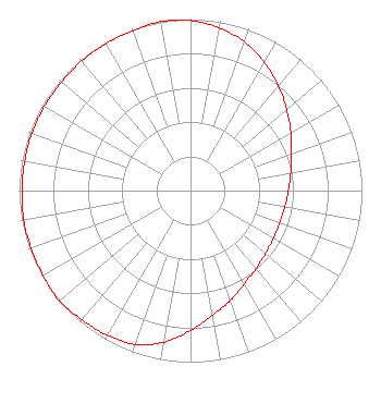 | ||||||||||||||||||
| Azimuth | Ratio | Azimuth | Ratio | Azimuth | Ratio | Azimuth | Ratio | ||||||||||||
| 0 | 0.991 | 10 | 0.963 | 20 | 0.923 | 30 | 0.862 | ||||||||||||
| 40 | 0.797 | 50 | 0.731 | 60 | 0.676 | 70 | 0.628 | ||||||||||||
| 80 | 0.594 | 90 | 0.571 | 100 | 0.558 | 110 | 0.553 | ||||||||||||
| 120 | 0.558 | 130 | 0.571 | 140 | 0.594 | 150 | 0.628 | ||||||||||||
| 160 | 0.682 | 170 | 0.738 | 180 | 0.815 | 190 | 0.897 | ||||||||||||
| 200 | 0.953 | 210 | 0.973 | 220 | 0.983 | 230 | 1.000 | ||||||||||||
| 240 | 0.992 | 250 | 0.988 | 260 | 0.988 | 270 | 0.983 | ||||||||||||
| 280 | 0.983 | 290 | 0.983 | 300 | 0.983 | 310 | 0.983 | ||||||||||||
| 320 | 0.988 | 330 | 0.988 | 340 | 0.992 | 350 | 1.000 | ||||||||||||
Structure Registration Number 1023824 Structure Type: GTOWER Registered To: METROPLEX COMMUNICATIONS, INC. Structure Address: 4700 Village Drive Alton, IL County Name: Madison County ASR Issued: 03/13/2014 Date Built: 03/31/2014 Site Elevation: 189 m (620 ft.) Structure Height: 105.6 m (346 ft.) Height Overall: 125.8 m (413 ft.) Overall Height AMSL: 314.8 m (1033 ft.) FAA Determination: 08/05/2013 FAA Study #: 2013-AGL-5476-OE FAA Circular #: 70/7460-1J Paint & Light FAA Chapters: 3, 4, 5, 13 PRIOR STUDY 1997-AGL-2238-OE CHAPTERS 3,4,5,13 (1J) ADD SPECIAL CONDITION FOR LIGHTING DEVIATION 38-55-41.0 N 90-13-03.0 W (NAD 83) 38-55-40.8 N 90-13-02.6 W (Converted to NAD 27) |
P.o. Box 615 Alton, IL 62002 Phone: 618-465-3535 Corporation | Title: President Date: 02/18/2020 Application Certifier METROPLEX COMMUNICATIONS, INC. Metroplex Communications, Inc. P.o. Box 615 Alton, IL 62002 Applicant David J. Doherty Skywaves Consulting Llc Skywaves Consulting Llc Po Box 4 Millbury, MA 01527 TECHNICAL CONSULTANT John F Garziglia Womble Bond Dickinson (us) Llp 1200 19th Street, N.w., Suite 500 Washington, DC 20036 | |||||||||||||||||