
FCCInfo.com
A Service of Cavell, Mertz & Associates, Inc.
(855) FCC-INFO
|
|
WNFN from 09/23/1996 WNFN from 09/22/1995 |
|  |
|
|||||||||||||||
|
|
WNFN Channel: 294C2 106.7 MHz Franklin, Tennessee Service: FM - A full-service FM station or application. Facility ID: 29862 Fac. Service: FM Status: License 73.215 Station Application Accepted: 02/24/2020 Application Granted: 12/28/2020 File Number: -0000106493 License Expires: 08/01/2028 Application Type: License To Cover FCC Website Links: LMS Facility Details This Application Other WNFN Applications Other WNFN Applications in CDBS Including Superseded Applications Mailing Address Correspondence for WNFN Correspondence related to application -0000106493 Service Contour - Open Street Map or USGS Map (60 dBu) Service Contour - KML / Google Earth (60 dBu) Public Inspection Files Facility Type: FM STATION Class: C2, A Zone II station; with 25kW-50kW ERP and a class contour distance 39km-52km Site Location: 36-02-50.0 N 86-49-49.0 W (NAD 83) Site Location: 36-02-49.8 N 86-49-49.0 W (Converted to NAD 27) Effective Radiated Power: 15 kW Antenna Center HAAT: 278 m (912 ft.) Antenna Center AMSL: 479 m (1572 ft.) Antenna Center HAG: 142 m (466 ft.) Calculated Site Elevation: 337 m. (1106 ft.) Height Overall*: 288 m (945 ft.) (* As Filed In This Application, may differ from ASR Data, Below.) Directional Antenna Antenna Make/Model: Electronics Research Inc. SHP-4AE-DA-HW Antenna ID: 127774 Polarization: | ||||||||||||||||||
| Antenna Data for Antenna Id: 127774 WNFN FM File: -0000106493 Electronics Research Inc. - SHP-4AE-DA-HW Service: FM | 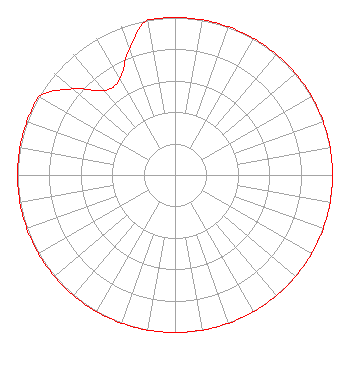 | ||||||||||||||||||
| Azimuth | Ratio | Azimuth | Ratio | Azimuth | Ratio | Azimuth | Ratio | ||||||||||||
| 0 | 1.000 | 10 | 1.000 | 20 | 1.000 | 30 | 1.000 | ||||||||||||
| 40 | 1.000 | 50 | 1.000 | 60 | 1.000 | 70 | 1.000 | ||||||||||||
| 80 | 1.000 | 90 | 1.000 | 100 | 1.000 | 110 | 1.000 | ||||||||||||
| 120 | 1.000 | 130 | 1.000 | 140 | 1.000 | 150 | 1.000 | ||||||||||||
| 160 | 1.000 | 170 | 1.000 | 180 | 1.000 | 190 | 1.000 | ||||||||||||
| 200 | 1.000 | 210 | 1.000 | 220 | 1.000 | 230 | 1.000 | ||||||||||||
| 240 | 1.000 | 250 | 1.000 | 260 | 1.000 | 270 | 1.000 | ||||||||||||
| 280 | 1.000 | 290 | 1.000 | 300 | 1.000 | 310 | 0.850 | ||||||||||||
| 320 | 0.700 | 330 | 0.700 | 340 | 0.850 | 350 | 1.000 | ||||||||||||
Structure Registration Number 1058822 Structure Type: TOWER Registered To: Nexstar Media Inc. Structure Address: 1406 Old Hickory Blvd. Nashville, TN County Name: Davidson County ASR Issued: 05/28/2021 Date Built: 02/02/2002 Site Elevation: 336.8 m (1105 ft.) Structure Height: 287.7 m (944 ft.) Height Overall: 287.7 m (944 ft.) Overall Height AMSL: 624.5 m (2049 ft.) FAA Determination: 09/30/1998 FAA Study #: 98-ASO-4498-OE FAA Circular #: 70/7460-1J Paint & Light FAA Chapters: 3, 4, 5, 13 SUPPLEMENTAL NOTICE STATES STRUCTURE REACHED GREATEST HEIGHT ON 02/02/2002 36-02-50.0 N 86-49-49.0 W (NAD 83) 36-02-49.8 N 86-49-49.0 W (Converted to NAD 27) |
904 Grand Ave. Wausau, WI 54403 Phone: 000-000-0000 Corporation | Title: Secretary Date: 02/24/2020 Application Certifier MIDWEST COMMUNICATIONS, INC. Midwest Communications, Inc. 904 Grand Ave. Wausau, WI 54403 Applicant John Neely, Esq Miller And Neely, Pc Suite 203 3750 University Blvd., West Kensington, MD 20895 counsel CHARLES M. ANDERSON Anderson Communications, Llc 1519 Euclid Avenue Bowling Green, KY 42103 ENGINEERING CONSULTANT | |||||||||||||||||
| |||||||||||||||||||