
FCCInfo.com
A Service of Cavell, Mertz & Associates, Inc.
(855) FCC-INFO
|
|
|
|
|
||||||||||||||||
|
|
W282CS Channel: 282D 104.3 MHz Sanford, Maine Service: FX - A translator or application for a translator. Facility ID: 201465 Fac. Service: FX Programming Delivery Method: Unspecified Status: License Application Accepted: 03/11/2020 Application Granted: 03/16/2020 File Number: -0000107668 License Expires: 04/01/2022 Application Type: License To Cover FCC Website Links: LMS Facility Details This Application Other W282CS Applications Other W282CS Applications in CDBS Including Superseded Applications Mailing Address Correspondence for W282CS Correspondence related to application -0000107668 Service Contour - Open Street Map or USGS Map (60 dBu) Service Contour - KML / Google Earth (60 dBu) Facility Type: FM STATION Class: D, A Noncommercial educational operating with no more than 10W Site Location: 43-25-11.0 N 70-48-09.0 W (NAD 83) Site Location: 43-25-10.7 N 70-48-10.8 W (Converted to NAD 27) Effective Radiated Power: 0.25 kW Transmitter Output Power: 0.27 kW Antenna Center HAAT: 0 m Antenna Center AMSL: 264 m (866 ft.) Antenna Center HAG: 61 m (200 ft.) Site Elevation: 203 m. (666 ft.) Height Overall*: 73 m (240 ft.) (* As Filed In This Application, may differ from ASR Data, Below.) Directional Antenna Antenna Make/Model: Shively 6812(DA) Antenna ID: 134730 Polarization: H
| ||||||||||||||||||
| Antenna Data for Antenna Id: 134730 W282CS FX File: -0000107668 Shively - 6812(DA) Service: FX | 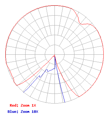 | ||||||||||||||||||
| Azimuth | Ratio | Azimuth | Ratio | Azimuth | Ratio | Azimuth | Ratio | ||||||||||||
| 0 | 1.000 | 10 | 1.000 | 20 | 1.000 | 30 | 0.920 | ||||||||||||
| 40 | 0.820 | 50 | 0.950 | 60 | 1.000 | 70 | 1.000 | ||||||||||||
| 80 | 1.000 | 90 | 1.000 | 100 | 1.000 | 110 | 1.000 | ||||||||||||
| 120 | 1.000 | 130 | 1.000 | 140 | 1.000 | 150 | 1.000 | ||||||||||||
| 160 | 0.500 | 170 | 0.045 | 180 | 0.030 | 190 | 0.032 | ||||||||||||
| 200 | 0.037 | 210 | 0.046 | 220 | 0.160 | 230 | 0.970 | ||||||||||||
| 240 | 0.970 | 250 | 0.970 | 260 | 1.000 | 270 | 1.000 | ||||||||||||
| 280 | 1.000 | 290 | 1.000 | 300 | 1.000 | 310 | 1.000 | ||||||||||||
| 320 | 1.000 | 330 | 1.000 | 340 | 1.000 | 350 | 1.000 | ||||||||||||
Structure Registration Number 1022900 Structure Type: TOWER Registered To: Aruba Capital Holdings, LLC Structure Address: Mount Hope Rd Cobbett Farm Sanford, ME County Name: York County ASR Issued: 09/27/2011 Date Built: 04/27/1987 Site Elevation: 203 m (666 ft.) Structure Height: 69 m (226 ft.) Height Overall: 73 m (240 ft.) Overall Height AMSL: 276 m (906 ft.) FAA Determination: 10/03/2000 FAA Study #: 00-ANE-0479-OE FAA Circular #: 70/7460-1K Paint & Light FAA Chapters: 3, 12 PRIOR STUDY 69-BOS-217-OE 43-25-11.0 N 70-48-09.0 W (NAD 83) 43-25-10.7 N 70-48-10.8 W (Converted to NAD 27) |
11 Downing Court Exeter, NH 03833-1903 Phone: 603-583-4767 Limited Liability Company | Title: Member Date: 03/11/2020 Application Certifier PORT BROADCASTING, LLC Port Broadcasting, Llc 11 Downing Court Exeter, NH 03833 Applicant KURT JACKSON Hampden Communications 82 Asnebumskit Rd Paxton, MA 01312 Pres. DENNIS JACKSON Dennis Jackson 19 Boas Lane Wilton, CT 06897 TECHNICAL CONSULTANT ALLAN G. MOSKOWITZ, ESQ. Moskowitz Law 10845 Tuckahoe Way North Potomac, MD 20878 | |||||||||||||||||