
FCCInfo.com
A Service of Cavell, Mertz & Associates, Inc.
(855) FCC-INFO
|
|
KTGV from 04/30/1999 KTGV from 04/17/1998 KTGV from 10/07/1991 KTGV from 10/31/1990 KTGV from 05/16/1988 |
|
|
||||||||||||||||
|
|
KTGV Channel: 292C2 106.3 MHz Oracle, Arizona Service: FS - A full service FM station auxiliary transmitting antenna or application. Facility ID: 57504 Fac. Service: FM Status: License Application Accepted: 07/13/2020 Application Granted: 07/07/2021 File Number: -0000116521 License Expires: 00/00/0000 Application Type: Amendment FCC Website Links: LMS Facility Details This Application Other KTGV Applications Other KTGV Applications in CDBS Including Superseded Applications Mailing Address Correspondence for KTGV Correspondence related to application -0000116521 Service Contour - Open Street Map or USGS Map (60 dBu) Service Contour - KML / Google Earth (60 dBu) Public Inspection Files Facility Type: FM STATION Class: C2, A Zone II station; with 25kW-50kW ERP and a class contour distance 39km-52km Site Location: 32-17-23.3 N 111-01-08.3 W (NAD 83) Site Location: 32-17-23.0 N 111-01-06.0 W (Converted to NAD 27) Effective Radiated Power: 10 kW Antenna Center HAAT: 105 m (344 ft.) Antenna Center AMSL: 899 m (2949 ft.) Antenna Center HAG: 211 m (692 ft.) Calculated Site Elevation: 688 m. (2257 ft.) Height Overall*: 221 m (725 ft.) (* As Filed In This Application, may differ from ASR Data, Below.) Directional Antenna Antenna Make/Model: Jampro JMPC-6 RFR .5 DA Antenna ID: 135279 Polarization: H
| ||||||||||||||||||
| Antenna Data for Antenna Id: 135279 KTGV FS File: -0000116521 Jampro - JMPC-6 RFR .5 DA Service: FS | 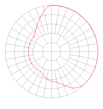 | ||||||||||||||||||
| Azimuth | Ratio | Azimuth | Ratio | Azimuth | Ratio | Azimuth | Ratio | ||||||||||||
| 0 | 1.000 | 10 | 1.000 | 20 | 1.000 | 30 | 1.000 | ||||||||||||
| 40 | 1.000 | 50 | 1.000 | 60 | 1.000 | 70 | 1.000 | ||||||||||||
| 80 | 1.000 | 90 | 1.000 | 100 | 1.000 | 110 | 1.000 | ||||||||||||
| 120 | 1.000 | 130 | 1.000 | 140 | 0.985 | 150 | 0.905 | ||||||||||||
| 160 | 0.764 | 170 | 0.671 | 180 | 0.638 | 190 | 0.592 | ||||||||||||
| 200 | 0.532 | 210 | 0.490 | 220 | 0.493 | 230 | 0.500 | ||||||||||||
| 240 | 0.500 | 250 | 0.500 | 260 | 0.500 | 270 | 0.500 | ||||||||||||
| 280 | 0.500 | 290 | 0.500 | 300 | 0.500 | 310 | 0.500 | ||||||||||||
| 320 | 0.551 | 330 | 0.630 | 340 | 0.745 | 350 | 0.895 | ||||||||||||
Structure Registration Number 1237818 Structure Type: TOWER Registered To: Arizona Lotus Corp. Structure Address: 2421 West Zinnia Avenue Tucson, AZ County Name: Pima County ASR Issued: 12/13/2018 Date Built: 04/14/2005 Site Elevation: 687.6 m (2256 ft.) Structure Height: 213.4 m (700 ft.) Height Overall: 220.7 m (724 ft.) Overall Height AMSL: 908.3 m (2980 ft.) FAA Determination: 12/26/2002 FAA Study #: 2002-AWP-1-OE FAA Circular #: 70/7460-1K Paint & Light FAA Chapters: 4, 8, 12 Removed expiration and final dates from determination. Scenario 2./jjs/case#635066 32-17-23.3 N 111-01-08.3 W (NAD 83) 32-17-23.0 N 111-01-06.0 W (Converted to NAD 27) |
5110 Se Stark Street Portland, OR 97215 Phone: 503-234-5550 Limited Liability Company | Title: Manager Date: 07/13/2020 Application Certifier BUSTOS MEDIA HOLDINGS, LLC Bustos Media Holdings, Llc 5110 Se Stark Street Portland, OR 97215 Applicant Dennis J. Kelly Law Office Of Dennis J. Kelly Post Office Box 41177 Washington, DC 20018-0577 Attorney | |||||||||||||||||