
FCCInfo.com
A Service of Cavell, Mertz & Associates, Inc.
(855) FCC-INFO
|
|
W236CR from 10/01/2015 W236CR from 12/11/2013 |
|
|
||||||||||||||||
|
|
W236CR Channel: 236D 95.1 MHz Indianapolis, Indiana Service: FX - A translator or application for a translator. Facility ID: 155847 Fac. Service: FX Programming Delivery Method: Unspecified Status: License Application Accepted: 07/17/2020 Application Granted: 07/28/2020 File Number: -0000117985 License Expires: 08/01/2020 Application Type: License To Cover FCC Website Links: LMS Facility Details This Application Other W236CR Applications Other W236CR Applications in CDBS Including Superseded Applications Mailing Address Correspondence for W236CR Correspondence related to application -0000117985 Service Contour - Open Street Map or USGS Map (60 dBu) Service Contour - KML / Google Earth (60 dBu) Facility Type: FM STATION Class: D, A Noncommercial educational operating with no more than 10W Site Location: 39-53-25.0 N 86-12-20.0 W (NAD 83) Site Location: 39-53-24.9 N 86-12-20.0 W (Converted to NAD 27) Effective Radiated Power: 0.25 kW Antenna Center HAAT: 0 m Antenna Center AMSL: 493.3 m (1618 ft.) Antenna Center HAG: 244 m (801 ft.) Site Elevation: 249.3 m. (818 ft.) Height Overall*: 319.4 m (1048 ft.) (* As Filed In This Application, may differ from ASR Data, Below.) Directional Antenna Antenna Make/Model: Electronics Research Inc. 100A-1M-DA Antenna ID: 134520 Polarization: H
| ||||||||||||||||||
| Antenna Data for Antenna Id: 134520 W236CR FX File: -0000117985 Electronics Research Inc. - 100A-1M-DA Service: FX | 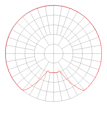 | ||||||||||||||||||
| Azimuth | Ratio | Azimuth | Ratio | Azimuth | Ratio | Azimuth | Ratio | ||||||||||||
| 0 | 1.000 | 10 | 1.000 | 20 | 1.000 | 30 | 1.000 | ||||||||||||
| 40 | 1.000 | 50 | 1.000 | 60 | 1.000 | 70 | 1.000 | ||||||||||||
| 80 | 1.000 | 90 | 1.000 | 100 | 1.000 | 110 | 1.000 | ||||||||||||
| 120 | 1.000 | 130 | 1.000 | 140 | 1.000 | 150 | 0.700 | ||||||||||||
| 160 | 0.400 | 170 | 0.400 | 180 | 0.400 | 190 | 0.400 | ||||||||||||
| 200 | 0.400 | 210 | 0.700 | 220 | 1.000 | 230 | 1.000 | ||||||||||||
| 240 | 1.000 | 250 | 1.000 | 260 | 1.000 | 270 | 1.000 | ||||||||||||
| 280 | 1.000 | 290 | 1.000 | 300 | 1.000 | 310 | 1.000 | ||||||||||||
| 320 | 1.000 | 330 | 1.000 | 340 | 1.000 | 350 | 1.000 | ||||||||||||
Structure Registration Number 1030817 Structure Type: TOWER Registered To: CCB License, LLC Structure Address: 7619 Walnut Dr Indianapolis, IN County Name: Marion County ASR Issued: 10/29/2019 Date Built: 12/31/1994 Site Elevation: 249.3 m (818 ft.) Structure Height: 275.5 m (904 ft.) Height Overall: 319.4 m (1048 ft.) Overall Height AMSL: 568.7 m (1866 ft.) FAA Determination: 05/06/1994 FAA Study #: 93-AGL-2149-OE FAA Circular #: 70/7460-1H Paint & Light FAA Chapters: 3, 4, 5, 13 39-53-25.0 N 86-12-20.0 W (NAD 83) 39-53-24.9 N 86-12-20.0 W (Converted to NAD 27) |
1010 Wayne Avenue 14th Floor Silver Spring, MD 20910 Phone: 301-429-3200 Limited Liability Company | Title: Corporate Engineer Date: 07/17/2020 Application Certifier RADIO ONE OF INDIANA, LLC Radio One Of Indiana, Llc 1010 Wayne Avenue 14th Floor Silver Spring, MD 20910 Applicant Sonya Hall-Harris Urban One, Inc 1010 Wayne Avenue, 14th Floor Silver Spring, MD 20910 Greg Strickland Urban One, Inc 1010 Wayne Avenue 14th Floor Silver Spring, MD 20910 Corporate Engineer | |||||||||||||||||