
FCCInfo.com
A Service of Cavell, Mertz & Associates, Inc.
(855) FCC-INFO
|
|
W245DZ from 09/25/2020 W245DZ from 06/16/2016 W245DZ from 06/16/2004 |
|
|
||||||||||||||||
|
|
W245DZ Channel: 245D 96.9 MHz Cleveland, Tennessee Service: FX - A translator or application for a translator. Facility ID: 138251 Fac. Service: FX Programming Delivery Method: Unspecified Status: License Application Accepted: 08/20/2020 Application Granted: 09/25/2020 File Number: -0000120612 License Expires: 08/01/2028 Application Type: License To Cover FCC Website Links: LMS Facility Details This Application Other W245DZ Applications Other W245DZ Applications in CDBS Including Superseded Applications Mailing Address Correspondence for W245DZ Correspondence related to application -0000120612 Service Contour - Open Street Map or USGS Map (60 dBu) Service Contour - KML / Google Earth (60 dBu) Facility Type: FM STATION Class: D, A Noncommercial educational operating with no more than 10W Site Location: 35-14-00.9 N 84-51-16.2 W (NAD 83) Site Location: 35-14-00.6 N 84-51-16.4 W (Converted to NAD 27) Effective Radiated Power: 0.25 kW Transmitter Output Power: 0.639 kW Antenna Center HAAT: 0 m Antenna Center AMSL: 349.9 m (1148 ft.) Antenna Center HAG: 93 m (305 ft.) Site Elevation: 256.9 m. (843 ft.) Height Overall*: 108.1 m (355 ft.) (* As Filed In This Application, may differ from ASR Data, Below.) Directional Antenna Antenna Make/Model: Nicom BKG77-1 Antenna ID: 135164 Polarization: H
| ||||||||||||||||||
| Antenna Data for Antenna Id: 135164 W245DZ FX File: -0000120612 Nicom - BKG77-1 Service: FX | 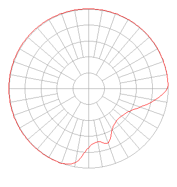 | ||||||||||||||||||
| Azimuth | Ratio | Azimuth | Ratio | Azimuth | Ratio | Azimuth | Ratio | ||||||||||||
| 0 | 1.000 | 10 | 1.000 | 20 | 1.000 | 30 | 1.000 | ||||||||||||
| 40 | 1.000 | 50 | 1.000 | 60 | 1.000 | 70 | 1.000 | ||||||||||||
| 80 | 1.000 | 90 | 0.988 | 100 | 0.844 | 110 | 0.688 | ||||||||||||
| 120 | 0.584 | 130 | 0.542 | 140 | 0.541 | 150 | 0.594 | ||||||||||||
| 160 | 0.724 | 170 | 0.680 | 180 | 0.745 | 190 | 0.943 | ||||||||||||
| 200 | 1.000 | 210 | 1.000 | 220 | 1.000 | 230 | 1.000 | ||||||||||||
| 240 | 1.000 | 250 | 1.000 | 260 | 1.000 | 270 | 1.000 | ||||||||||||
| 280 | 1.000 | 290 | 1.000 | 300 | 1.000 | 310 | 1.000 | ||||||||||||
| 320 | 1.000 | 330 | 1.000 | 340 | 1.000 | 350 | 1.000 | ||||||||||||
Structure Registration Number 1225249 Structure Type: TOWER Registered To: American Towers LLC Structure Address: 5600 Frontage Road Nw (075417) Calhoun, TN County Name: Bradley County ASR Issued: 06/24/2016 Date Built: 02/25/1999 Site Elevation: 256.9 m (843 ft.) Structure Height: 105.1 m (345 ft.) Height Overall: 108.1 m (355 ft.) Overall Height AMSL: 365 m (1198 ft.) FAA Determination: 08/02/1999 FAA Study #: 99-ASO-3740-OE FAA Circular #: 70/7460-1J Paint & Light FAA Chapters: 4, 8, 13 PRIOR FAA 98-ASO-7431-OE PROJECT STATUS REPORT STATES CONSTRUCTION COMPLETED ON 07/19/1999 35-14-00.9 N 84-51-16.2 W (NAD 83) 35-14-00.6 N 84-51-16.4 W (Converted to NAD 27) |
912 Forest Ridge Cir Knoxville, TN 37932 Phone: 865-216-8410 Limited Liability Company | Title: Managing Partner Date: 08/20/2020 Application Certifier BEVERLY BROADCASTING COMPANY, LLC Beverly Broadcasting Company, Llc 912 Forest Ridge Cir Knoxville, TN 37932 Applicant Michael R Beverly Beverly Broadcasting Co. Llc 912 Forest Ridge Cir Knoxville, TN 37932 | |||||||||||||||||