
FCCInfo.com
A Service of Cavell, Mertz & Associates, Inc.
(855) FCC-INFO
|
|
|
|
|
||||||||||||||||
|
|
W300EE Channel: 300D 107.9 MHz Manitowoc, Wisconsin Service: FX - A translator or application for a translator. Facility ID: 202714 Fac. Service: FX Programming Delivery Method: Unspecified Status: License Application Accepted: 09/25/2020 Application Granted: 02/02/2021 File Number: -0000114284 License Expires: 12/01/2028 Application Type: Amendment FCC Website Links: LMS Facility Details This Application Other W300EE Applications Other W300EE Applications in CDBS Including Superseded Applications Mailing Address Correspondence for W300EE Correspondence related to application -0000114284 Service Contour - Open Street Map or USGS Map (60 dBu) Service Contour - KML / Google Earth (60 dBu) Facility Type: FM STATION Class: D, A Noncommercial educational operating with no more than 10W Site Location: 44-07-31.0 N 87-37-41.3 W (NAD 83) Site Location: 44-07-31.0 N 87-37-41.0 W (Converted to NAD 27) Effective Radiated Power: 0.22 kW Antenna Center HAAT: 0 m Antenna Center AMSL: 303 m (994 ft.) Antenna Center HAG: 120 m (394 ft.) Site Elevation: 183 m. (600 ft.) Height Overall*: 152 m (499 ft.) (* As Filed In This Application, may differ from ASR Data, Below.) Directional Antenna Antenna Make/Model: Nicom BKG-77 Antenna ID: 133974 Polarization: H
| ||||||||||||||||||
| Antenna Data for Antenna Id: 133974 W300EE FX File: -0000114284 Nicom - BKG-77 Service: FX | 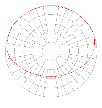 | ||||||||||||||||||
| Azimuth | Ratio | Azimuth | Ratio | Azimuth | Ratio | Azimuth | Ratio | ||||||||||||
| 0 | 0.983 | 10 | 0.983 | 20 | 0.983 | 30 | 0.988 | ||||||||||||
| 40 | 0.988 | 50 | 0.992 | 60 | 1.000 | 70 | 0.994 | ||||||||||||
| 80 | 0.963 | 90 | 0.923 | 100 | 0.862 | 110 | 0.797 | ||||||||||||
| 120 | 0.731 | 130 | 0.676 | 140 | 0.628 | 150 | 0.594 | ||||||||||||
| 160 | 0.571 | 170 | 0.558 | 180 | 0.553 | 190 | 0.558 | ||||||||||||
| 200 | 0.571 | 210 | 0.594 | 220 | 0.628 | 230 | 0.682 | ||||||||||||
| 240 | 0.738 | 250 | 0.815 | 260 | 0.897 | 270 | 0.953 | ||||||||||||
| 280 | 0.973 | 290 | 0.983 | 300 | 1.000 | 310 | 0.992 | ||||||||||||
| 320 | 0.988 | 330 | 0.988 | 340 | 0.983 | 350 | 0.983 | ||||||||||||
Structure Registration Number 1034205 Structure Type: Registered To: Seehafer Broadcasting Corp WQTC WLTU Structure Address: 1915 Mirro Dr Manitowoc, WI County Name: Manitowoc County ASR Issued: 11/06/2015 Date Built: 01/17/1986 Site Elevation: 182.9 m (600 ft.) Structure Height: 151 m (495 ft.) Height Overall: 152 m (499 ft.) Overall Height AMSL: 334.9 m (1099 ft.) FAA Determination: 10/01/1984 FAA Study #: 83-AGL-1439-OE FAA Circular #: 70/7460-1F Paint & Light FAA Chapters: 3, 4, 5, 9 RED LIGHTS/PAINT 44-07-31.0 N 87-37-41.0 W (NAD 83) 44-07-31.0 N 87-37-40.7 W (Converted to NAD 27) |
3730 Mangin Street Manitowoc, WI 54220 Phone: 920-682-0351 Corporation | Title: President Date: 09/25/2020 Application Certifier SEEHAFER BROADCASTING CORP Seehafer Broadcasting Corp 3730 Mangin Street Manitowoc, WI 54220 Applicant JOHN Neely, ESQ Miller And Neely, P.c. 3750 University Blvd., West Suite 203 Kensington, MD 20895 | |||||||||||||||||