
FCCInfo.com
A Service of Cavell, Mertz & Associates, Inc.
(855) FCC-INFO
|
|
WLKC from 06/15/2005 WLKC from 03/20/1989 |
|  |
|
|||||||||||||||
|
|
WLKC Channel: 289A 105.7 MHz Campton, New Hampshire Service: FM - A full-service FM station or application. Facility ID: 72211 Fac. Service: FM Status: License 73.215 Station Application Accepted: 09/25/2020 Application Granted: 02/03/2021 File Number: -0000122433 License Expires: 04/01/2022 Application Type: Minor Modification FCC Website Links: LMS Facility Details This Application Other WLKC Applications Other WLKC Applications in CDBS Including Superseded Applications Mailing Address Correspondence for WLKC Correspondence related to application -0000122433 Service Contour - Open Street Map or USGS Map (60 dBu) Service Contour - KML / Google Earth (60 dBu) Public Inspection Files Facility Type: NON-COMMERCIAL EDUC. FM Class: A, A Zone I; I-A; or II station; with 0.1kW-6kW ERP and a class contour distance <=28km Site Location: 43-45-45.3 N 71-38-58.3 W (NAD 83) Site Location: 43-45-45.0 N 71-39-00.0 W (Converted to NAD 27) Effective Radiated Power: 4.1 kW Transmitter Output Power: 3.9 kW Antenna Center HAAT: 119 m (390 ft.) Antenna Center AMSL: 412 m (1352 ft.) Antenna Center HAG: 95 m (312 ft.) Calculated Site Elevation: 317 m. (1040 ft.) Height Overall*: 98 m (322 ft.) (* As Filed In This Application, may differ from ASR Data, Below.) Directional Antenna Antenna Make/Model: Shivley 6810 Antenna ID: 71222 Polarization: | ||||||||||||||||||
| Antenna Data for Antenna Id: 71222 WLKC FM File: -0000122433 Shivley - 6810 Service: FM | 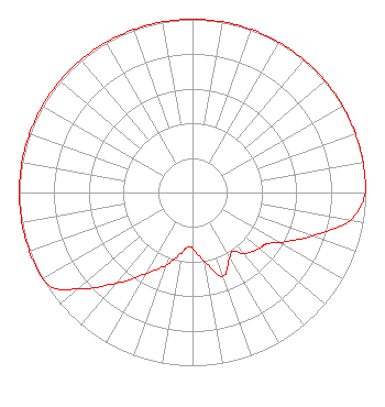 | ||||||||||||||||||
| Azimuth | Ratio | Azimuth | Ratio | Azimuth | Ratio | Azimuth | Ratio | ||||||||||||
| 0 | 1.000 | 10 | 1.000 | 20 | 1.000 | 30 | 1.000 | ||||||||||||
| 40 | 1.000 | 50 | 1.000 | 60 | 1.000 | 70 | 1.000 | ||||||||||||
| 80 | 1.000 | 90 | 1.000 | 100 | 0.923 | 110 | 0.733 | ||||||||||||
| 120 | 0.582 | 125 | 0.519 | 130 | 0.501 | 140 | 0.462 | ||||||||||||
| 145 | 0.412 | 150 | 0.432 | 160 | 0.513 | 170 | 0.407 | ||||||||||||
| 180 | 0.324 | 185 | 0.316 | 190 | 0.355 | 200 | 0.447 | ||||||||||||
| 210 | 0.543 | 220 | 0.684 | 230 | 0.861 | 235 | 0.966 | ||||||||||||
| 240 | 1.000 | 250 | 1.000 | 260 | 1.000 | 270 | 1.000 | ||||||||||||
| 280 | 1.000 | 290 | 1.000 | 300 | 1.000 | 310 | 1.000 | ||||||||||||
| 320 | 1.000 | 330 | 1.000 | 340 | 1.000 | 350 | 1.000 | ||||||||||||
Structure Registration Number 1055700 [ASR Heights Differ from WLKC Application] Structure Type: TOWER Registered To: SBA Towers II LLC Structure Address: 3.2 Km Ene On Smith Hill Rd Holderness, NH County Name: Grafton County ASR Issued: 01/22/2009 Date Built: 06/20/2008 Site Elevation: 314.8 m (1033 ft.) Structure Height: 91.4 m (300 ft.) Height Overall: 102.1 m (335 ft.) Overall Height AMSL: 416.9 m (1368 ft.) FAA Determination: 01/30/2008 FAA Study #: 2008-ANE-63-OE FAA Circular #: 70/7460-1K Paint & Light FAA Chapters: 4, 8, 12 PRIOR STUDY 2007-ANE-1883-OE 43-45-45.6 N 71-38-58.1 W (NAD 83) 43-45-45.3 N 71-38-59.8 W (Converted to NAD 27) |
5700 West Oaks Blvd Rocklin, CA 95765 Phone: 916-251-1600 Not-for-Profit | Title: Ceo Date: 09/25/2020 Application Certifier DEVON BROADCASTING COMPANY, INC. Educational Media Foundation 5700 West Oaks Blvd. Rocklin, CA 95765 Applicant Mary N O'Connor Wilkinson Barker Knauer, Llp 1800 M Street, Nw Suite 800n Washington, DC 20036 | |||||||||||||||||