
FCCInfo.com
A Service of Cavell, Mertz & Associates, Inc.
(855) FCC-INFO
|
|
K238CC from 12/02/2013 |
|
|
||||||||||||||||
|
|
K238CC Channel: 238D 95.5 MHz Dallas, Texas Service: FX - A translator or application for a translator. Facility ID: 156287 Fac. Service: FX Programming Delivery Method: Unspecified Status: License Application Accepted: 09/28/2020 Application Granted: 10/08/2020 File Number: -0000122540 License Expires: 08/01/2021 Application Type: License To Cover FCC Website Links: LMS Facility Details This Application Other K238CC Applications Other K238CC Applications in CDBS Including Superseded Applications Mailing Address Correspondence for K238CC Correspondence related to application -0000122540 Service Contour - Open Street Map or USGS Map (60 dBu) Service Contour - KML / Google Earth (60 dBu) Facility Type: FM STATION Class: D, A Noncommercial educational operating with no more than 10W Site Location: 32-52-15.5 N 96-55-25.0 W (NAD 83) Site Location: 32-52-15.0 N 96-55-24.0 W (Converted to NAD 27) Effective Radiated Power: 0.25 kW Antenna Center HAAT: 112 m (367 ft.) Antenna Center AMSL: 264 m (866 ft.) Antenna Center HAG: 134 m (440 ft.) Site Elevation: 130 m. (427 ft.) Height Overall*: 190 m (623 ft.) (* As Filed In This Application, may differ from ASR Data, Below.) Directional Antenna Antenna Make/Model: KATHREIN CL-FM Antenna ID: 133267 Polarization: H
| ||||||||||||||||||
| Antenna Data for Antenna Id: 133267 K238CC FX File: -0000122540 KATHREIN - CL-FM Service: FX | 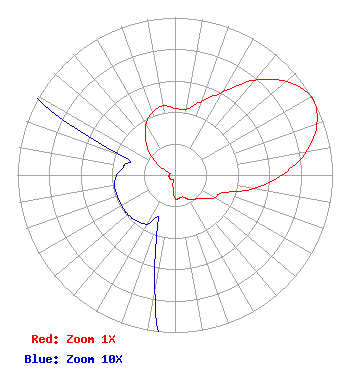 | ||||||||||||||||||
| Azimuth | Ratio | Azimuth | Ratio | Azimuth | Ratio | Azimuth | Ratio | ||||||||||||
| 0 | 0.424 | 10 | 0.424 | 20 | 0.499 | 30 | 0.609 | ||||||||||||
| 40 | 0.784 | 50 | 0.923 | 60 | 0.999 | 62 | 1.000 | ||||||||||||
| 70 | 0.959 | 80 | 0.845 | 90 | 0.679 | 100 | 0.504 | ||||||||||||
| 110 | 0.326 | 120 | 0.289 | 130 | 0.229 | 140 | 0.199 | ||||||||||||
| 150 | 0.179 | 160 | 0.149 | 170 | 0.149 | 180 | 0.149 | ||||||||||||
| 190 | 0.074 | 200 | 0.031 | 210 | 0.036 | 220 | 0.038 | ||||||||||||
| 230 | 0.039 | 240 | 0.039 | 250 | 0.039 | 260 | 0.039 | ||||||||||||
| 270 | 0.037 | 280 | 0.033 | 290 | 0.037 | 300 | 0.111 | ||||||||||||
| 310 | 0.209 | 320 | 0.289 | 330 | 0.369 | 340 | 0.424 | ||||||||||||
| 350 | 0.446 | ||||||||||||||||||
Structure Registration Number 1053400 [ASR Heights Differ from K238CC Application] Structure Type: GTOWER Registered To: American Towers LLC Structure Address: 1680 West Northwest Highway (30488) Dallas, TX County Name: Dallas County ASR Issued: 11/30/2023 Date Built: 10/08/2012 Site Elevation: 129.5 m (425 ft.) Structure Height: 175.3 m (575 ft.) Height Overall: 189.9 m (623 ft.) Overall Height AMSL: 319.4 m (1048 ft.) FAA Determination: 01/13/2023 FAA Study #: 2022-ASW-6517-OE FAA Circular #: 70/7460-1M Paint & Light FAA Chapters: 4, 8, 15 PRIOR STUDIES 2013-ASW-2470-OE / 2022-ASW-2030-OE 32-52-15.5 N 96-55-24.8 W (NAD 83) 32-52-15.0 N 96-55-23.8 W (Converted to NAD 27) |
6850 Tpc Dr. Suite 108 Mckinney, TX 75070 Phone: 214-454-7230 Limited Liability Company | Title: Consulting Engineer Date: 09/28/2020 Application Certifier DECATUR MEDIA LAND, LLC Decatur Media Land, Llc 6850 Tpc Dr. Suite 108 Mckinney, TX 75070 Applicant JOSEPH C. CHAUTIN, III Hardy, Carey, Chautin & Balkin, Llp 1080 West Causeway Approach Mandeville, LA 70471 ESQ. CLARENCE BEVERAGE Communications Technologies, Inc. Communications Technologies, Inc. P.o. Box 1130 Marlton, NJ 08053 BROADCAST ENGINEERING CONSULTANT | |||||||||||||||||