
FCCInfo.com
A Service of Cavell, Mertz & Associates, Inc.
(855) FCC-INFO
|
|
W269DY from 11/04/2020 W269DY from 07/14/2008 |
|
|
||||||||||||||||
|
|
W269DY Channel: 269D 101.7 MHz Allentown, Pennsylvania Service: FX - A translator or application for a translator. Facility ID: 141564 Fac. Service: FX Programming Delivery Method: Unspecified Status: License Application Accepted: 10/06/2020 Application Granted: 11/04/2020 File Number: -0000124067 License Expires: 08/01/2022 Application Type: License To Cover FCC Website Links: LMS Facility Details This Application Other W269DY Applications Other W269DY Applications in CDBS Including Superseded Applications Mailing Address Correspondence for W269DY Correspondence related to application -0000124067 Service Contour - Open Street Map or USGS Map (60 dBu) Service Contour - KML / Google Earth (60 dBu) Facility Type: FM STATION Class: D, A Noncommercial educational operating with no more than 10W Site Location: 40-35-55.0 N 75-25-11.0 W (NAD 83) Site Location: 40-35-54.6 N 75-25-12.3 W (Converted to NAD 27) Effective Radiated Power: 0 kW Horiz. ; 0.004 kW Vert. Transmitter Output Power: 0.027 kW Antenna Center HAAT: 0 m Antenna Center AMSL: 0 m Horiz.; 335 m Vert. Antenna Center HAG: 0 m Horiz.; 73 m Vert. Site Elevation: 262 m. (860 ft.) Height Overall*: 96 m (315 ft.) (* As Filed In This Application, may differ from ASR Data, Below.) Directional Antenna Antenna Make/Model: Samco 159FM Antenna ID: 127732 Polarization: H
| ||||||||||||||||||
| Antenna Data for Antenna Id: 127732 W269DY FX File: -0000124067 Samco - 159FM Service: FX | 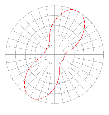 | ||||||||||||||||||
| Azimuth | Ratio | Azimuth | Ratio | Azimuth | Ratio | Azimuth | Ratio | ||||||||||||
| 0 | 0.683 | 10 | 0.853 | 20 | 0.973 | 28 | 1.000 | ||||||||||||
| 30 | 0.993 | 40 | 0.938 | 50 | 0.789 | 60 | 0.608 | ||||||||||||
| 70 | 0.418 | 80 | 0.262 | 90 | 0.219 | 100 | 0.210 | ||||||||||||
| 110 | 0.203 | 120 | 0.202 | 130 | 0.206 | 140 | 0.214 | ||||||||||||
| 150 | 0.231 | 160 | 0.308 | 170 | 0.493 | 180 | 0.683 | ||||||||||||
| 190 | 0.853 | 200 | 0.973 | 208 | 1.000 | 210 | 0.993 | ||||||||||||
| 220 | 0.938 | 230 | 0.789 | 240 | 0.608 | 250 | 0.418 | ||||||||||||
| 260 | 0.262 | 270 | 0.219 | 280 | 0.210 | 290 | 0.203 | ||||||||||||
| 300 | 0.202 | 310 | 0.206 | 320 | 0.214 | 330 | 0.231 | ||||||||||||
| 340 | 0.308 | 350 | 0.493 | ||||||||||||||||
Structure Registration Number 1026723 [ASR Heights Differ from W269DY Application] Structure Type: LTOWER Registered To: SERVICE ELECTRIC CABLE TV, INC. Structure Address: One Mile East Of Salisbury Twp., Pa 18015 Salisbury Twp., PA County Name: Lehigh County ASR Issued: 04/04/2024 Date Built: 03/01/1991 Site Elevation: 253 m (830 ft.) Structure Height: 99 m (325 ft.) Height Overall: 99 m (325 ft.) Overall Height AMSL: 352 m (1155 ft.) FAA Determination: 03/25/2024 FAA Study #: 2024-AEA-1408-OE FAA Circular #: 70/7460-1M Paint & Light FAA Chapters: 4, 8, 15 PRIOR STUDY 2023-AEA-14936-OE 40-35-55.7 N 75-25-07.6 W (NAD 83) 40-35-55.3 N 75-25-08.9 W (Converted to NAD 27) |
1125 Colorado Street Allentown, PA 18103 Phone: 610-434-4801 Limited Liability Company | Title: Technical Consultant Date: 10/06/2020 Application Certifier VP BROADCASTING, LLC Vp Broadcasting, Llc 1125 Colorado Street Allentown, PA 18103 Applicant Matthew Braccili V.p. Broadcasting, Llc 1125 Colorado Street Allentown, PA 18103 Manager Kyle Magrill Kyle Magrill 2805 Nw 6th Street Gainesville, FL 32609 Technical Consultant | |||||||||||||||||