
FCCInfo.com
A Service of Cavell, Mertz & Associates, Inc.
(855) FCC-INFO
|
|
|
|
|
||||||||||||||||
|
|
K221GU Channel: 221D 92.1 MHz Crookston, Minnesota Service: FX - A translator or application for a translator. Facility ID: 202642 Fac. Service: FX Programming Delivery Method: Unspecified Status: License Application Accepted: 10/13/2020 Application Granted: 11/09/2020 File Number: -0000124432 License Expires: 04/01/2021 Application Type: License To Cover FCC Website Links: LMS Facility Details This Application Other K221GU Applications Other K221GU Applications in CDBS Including Superseded Applications Mailing Address Correspondence for K221GU Correspondence related to application -0000124432 Service Contour - Open Street Map or USGS Map (60 dBu) Service Contour - KML / Google Earth (60 dBu) Facility Type: FM STATION Class: D, A Noncommercial educational operating with no more than 10W Site Location: 47-55-52.9 N 97-02-35.3 W (NAD 83) Site Location: 47-55-53.0 N 97-02-34.0 W (Converted to NAD 27) Effective Radiated Power: 0.25 kW Antenna Center HAAT: 0 m Antenna Center AMSL: 307 m (1007 ft.) Antenna Center HAG: 55 m (180 ft.) Site Elevation: 252 m. (827 ft.) Height Overall*: 73 m (240 ft.) (* As Filed In This Application, may differ from ASR Data, Below.) Directional Antenna Antenna Make/Model: NIC BKG77-2 Antenna ID: 133794 Polarization: H
| ||||||||||||||||||
| Antenna Data for Antenna Id: 133794 K221GU FX File: -0000124432 NIC - BKG77-2 Service: FX Pattern and Field Values Include a 120° Clockwise Rotation | 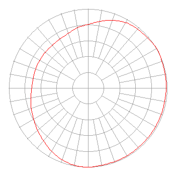 | ||||||||||||||||||
| Azimuth | Ratio | Azimuth | Ratio | Azimuth | Ratio | Azimuth | Ratio | ||||||||||||
| 0 | 0.802 | 10 | 0.853 | 20 | 0.909 | 30 | 0.953 | ||||||||||||
| 40 | 0.973 | 50 | 0.983 | 60 | 1.000 | 70 | 0.992 | ||||||||||||
| 80 | 0.988 | 90 | 0.988 | 100 | 0.983 | 110 | 0.983 | ||||||||||||
| 120 | 0.983 | 130 | 0.983 | 140 | 0.983 | 150 | 0.988 | ||||||||||||
| 160 | 0.988 | 170 | 0.992 | 180 | 1.000 | 190 | 0.991 | ||||||||||||
| 200 | 0.963 | 210 | 0.923 | 220 | 0.873 | 230 | 0.832 | ||||||||||||
| 240 | 0.792 | 250 | 0.762 | 260 | 0.732 | 270 | 0.710 | ||||||||||||
| 280 | 0.702 | 290 | 0.702 | 300 | 0.702 | 310 | 0.702 | ||||||||||||
| 320 | 0.702 | 330 | 0.712 | 340 | 0.732 | 350 | 0.772 | ||||||||||||
Structure Registration Number 1251781 [ASR Heights Differ from K221GU Application] Structure Type: TOWER Structure Address: 314 9th Street North Grand Forks, ND County Name: Grand Forks County ASR Issued: 11/23/2010 Date Built: 10/31/2010 Site Elevation: 252.4 m (828 ft.) Structure Height: 69.2 m (227 ft.) Height Overall: 72.5 m (238 ft.) Overall Height AMSL: 324.9 m (1066 ft.) FAA Determination: 08/03/1998 FAA Study #: 98-agl-3124-oe Paint & Light FAA Chapters: 1, 3, 11, 21 RED LIGHTS/PAINT. 47-55-52.9 N 97-02-35.2 W (NAD 83) 47-55-53.0 N 97-02-33.9 W (Converted to NAD 27) |
Crookston, MN 56716 Phone: 218-281-1140 Corporation | Title: President Date: 10/13/2020 Application Certifier GOPHER COMMUNICATIONS COMPANY Gopher Communications Company Crookston, MN 56716 Applicant Gene Wisniewski World Radio Link, Inc. Twin Falls, ID 83303 CONSULTING ENGINEER Lee G Petro Pillsbury Winthrop Shaw Pittman Llp 1200 Seventeenth Street, N.w. Washington, DC 20036 Attorney | |||||||||||||||||