
FCCInfo.com
A Service of Cavell, Mertz & Associates, Inc.
(855) FCC-INFO
|
|
|
|
|
||||||||||||||||
|
|
W270DE Channel: 270D 101.9 MHz Lexington, Kentucky Service: FX - A translator or application for a translator. Facility ID: 200913 Fac. Service: FX Programming Delivery Method: Unspecified Status: License Application Accepted: 12/08/2020 Application Granted: 12/16/2020 File Number: -0000127307 License Expires: 08/01/2028 Application Type: Amendment FCC Website Links: LMS Facility Details This Application Other W270DE Applications Other W270DE Applications in CDBS Including Superseded Applications Mailing Address Correspondence for W270DE Correspondence related to application -0000127307 Service Contour - Open Street Map or USGS Map (60 dBu) Service Contour - KML / Google Earth (60 dBu) Facility Type: FM STATION Class: D, A Noncommercial educational operating with no more than 10W Site Location: 38-03-56.3 N 84-29-12.8 W (NAD 83) Site Location: 38-03-56.0 N 84-29-13.0 W (Converted to NAD 27) Effective Radiated Power: 0.045 kW Antenna Center HAAT: 0 m Antenna Center AMSL: 376 m (1234 ft.) Antenna Center HAG: 87 m (285 ft.) Site Elevation: 289 m. (948 ft.) Height Overall*: 183 m (600 ft.) (* As Filed In This Application, may differ from ASR Data, Below.) Directional Antenna Antenna Make/Model: NICOM BKG77 Antenna ID: 130070 Polarization:
| ||||||||||||||||||
| Antenna Data for Antenna Id: 130070 W270DE FX File: -0000127307 NICOM - BKG77 Service: FX | 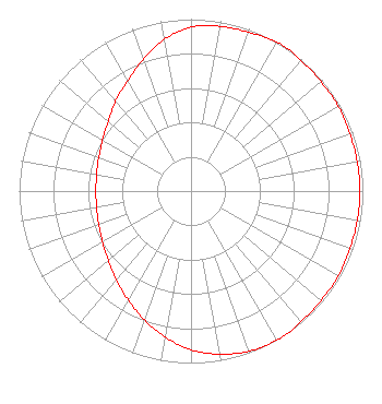 | ||||||||||||||||||
| Azimuth | Ratio | Azimuth | Ratio | Azimuth | Ratio | Azimuth | Ratio | ||||||||||||
| 0 | 0.953 | 10 | 0.973 | 20 | 0.983 | 30 | 1.000 | ||||||||||||
| 35 | 1.000 | 40 | 0.992 | 50 | 0.988 | 60 | 0.988 | ||||||||||||
| 70 | 0.983 | 80 | 0.983 | 90 | 0.983 | 100 | 0.983 | ||||||||||||
| 110 | 0.983 | 120 | 0.988 | 130 | 0.988 | 140 | 0.992 | ||||||||||||
| 145 | 1.000 | 150 | 1.000 | 160 | 0.991 | 170 | 0.963 | ||||||||||||
| 180 | 0.923 | 190 | 0.862 | 200 | 0.797 | 210 | 0.731 | ||||||||||||
| 220 | 0.676 | 230 | 0.628 | 240 | 0.594 | 250 | 0.571 | ||||||||||||
| 260 | 0.558 | 270 | 0.553 | 280 | 0.558 | 290 | 0.571 | ||||||||||||
| 300 | 0.594 | 310 | 0.628 | 320 | 0.682 | 330 | 0.738 | ||||||||||||
| 340 | 0.815 | 350 | 0.897 | ||||||||||||||||
Structure Registration Number 1043247 [ASR Heights Differ from W270DE Application] Structure Type: TOWER Registered To: Scripps Broadcasting Holdings LLC Structure Address: 1065 Russell Cave Road Lexington, KY County Name: Fayette County ASR Issued: 05/02/2019 Date Built: 01/01/1959 Site Elevation: 289.6 m (950 ft.) Structure Height: 183.1 m (601 ft.) Height Overall: 204.3 m (670 ft.) Overall Height AMSL: 493.9 m (1620 ft.) Paint & Light FAA Chapters: 1, 3, 5, 14, 21 38-03-56.0 N 84-29-13.0 W (NAD 83) 38-03-55.7 N 84-29-13.2 W (Converted to NAD 27) |
Po Box 2623 Clarksville, IN 47131 Phone: 502-584-2400 Corporation | Title: Vp/co-owner Date: 12/08/2020 Application Certifier NEW ALBANY BROADCASTING CO. INC. New Albany Broadcasting Co. Inc. Po Box 2623 Clarksville, IN 47131 Applicant DAVID B. SMITH New Albany Broadcasting Co., Inc. 220 Potters Lane Clarksville, IN 47129 VP/GM MICHELLE Bradley Rec Rec Networks 11541 Riverton Wharf Rd Mardela Springs, MD 21837 CONSULTANT Peter Charles Boyce New Albany Broadcasting Co., Inc. 410 Mt. Tabor Road New Albany, IN 47150 Co-Owner | |||||||||||||||||