
FCCInfo.com
A Service of Cavell, Mertz & Associates, Inc.
(855) FCC-INFO
|
|
|
|  |
|
|||||||||||||||
|
|
WGLE Channel: 214B 90.7 MHz Lima, Ohio Service: FM - A full-service FM station or application. Facility ID: 53715 Fac. Service: FM Status: License Application Accepted: 12/22/2020 Application Granted: 01/04/2021 File Number: -0000130021 License Expires: 10/01/2028 Application Type: License To Cover FCC Website Links: LMS Facility Details This Application Other WGLE Applications Other WGLE Applications in CDBS Including Superseded Applications Mailing Address Correspondence for WGLE Correspondence related to application -0000130021 Service Contour - Open Street Map or USGS Map (60 dBu) Service Contour - KML / Google Earth (60 dBu) Public Inspection Files History Cards for WGLE Facility Type: NON-COMMERCIAL EDUC. FM Class: B, A Zone I or I-A station; with 25kW-50kW ERP and a class contour distance 39km-52km Site Location: 40-39-04.1 N 84-06-33.1 W (NAD 83) Site Location: 40-39-03.9 N 84-06-33.3 W (Converted to NAD 27) Effective Radiated Power: 50 kW Transmitter Output Power: 24 kW Antenna Center HAAT: 139 m (456 ft.) Antenna Center AMSL: 416 m (1365 ft.) Antenna Center HAG: 126 m (413 ft.) Site Elevation: 289.6 m. (950 ft.) Height Overall*: 135 m (443 ft.) (* As Filed In This Application, may differ from ASR Data, Below.) Directional Antenna Antenna Make/Model: Electronics Research Inc. FMD-3B Antenna ID: 13483 Polarization: | ||||||||||||||||||
| Antenna Data for Antenna Id: 13483 WGLE FM File: -0000130021 Electronics Research Inc. - FMD-3B Service: FM | 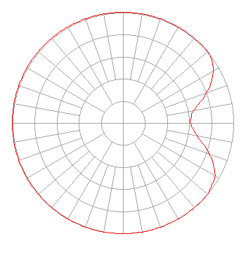 | ||||||||||||||||||
| Azimuth | Ratio | Azimuth | Ratio | Azimuth | Ratio | Azimuth | Ratio | ||||||||||||
| 0 | 1.000 | 10 | 1.000 | 20 | 1.000 | 30 | 1.000 | ||||||||||||
| 40 | 1.000 | 50 | 1.000 | 55 | 0.980 | 60 | 0.940 | ||||||||||||
| 65 | 0.880 | 70 | 0.800 | 80 | 0.650 | 85 | 0.620 | ||||||||||||
| 90 | 0.610 | 100 | 0.680 | 110 | 0.830 | 115 | 0.900 | ||||||||||||
| 120 | 0.960 | 125 | 0.980 | 130 | 1.000 | 140 | 1.000 | ||||||||||||
| 150 | 1.000 | 160 | 1.000 | 170 | 1.000 | 180 | 1.000 | ||||||||||||
| 190 | 1.000 | 200 | 1.000 | 210 | 1.000 | 220 | 1.000 | ||||||||||||
| 230 | 1.000 | 240 | 1.000 | 250 | 1.000 | 260 | 1.000 | ||||||||||||
| 270 | 1.000 | 280 | 1.000 | 290 | 1.000 | 300 | 1.000 | ||||||||||||
| 310 | 1.000 | 320 | 1.000 | 330 | 1.000 | 340 | 1.000 | ||||||||||||
| 350 | 1.000 | ||||||||||||||||||
Structure Registration Number 1015067 Structure Type: GTOWER Registered To: PUBLIC BROADCASTING FOUNDATION OF NORTHWEST OHIO Structure Address: Nr Sw Cor Of National And Townline Lima Rds Cridersville, OH County Name: Auglaize County ASR Issued: 11/04/2020 Date Built: 07/03/1981 Site Elevation: 289.6 m (950 ft.) Structure Height: 134.1 m (440 ft.) Height Overall: 135 m (443 ft.) Overall Height AMSL: 424.6 m (1393 ft.) FAA Determination: 10/29/2020 FAA Study #: 2020-AGL-20038-OE FAA Circular #: 70/7460-1L Paint & Light FAA Chapters: 3, 4, 5, 12 PRIOR STUDY 1980-AGL-450-OE 40-39-04.1 N 84-06-33.1 W (NAD 83) 40-39-03.9 N 84-06-33.3 W (Converted to NAD 27) |
Box 30 Toledo, OH 43614 Phone: 419-380-4600 Not-for-Profit | Title: President And Ceo Date: 12/22/2020 Application Certifier PUBLIC BROADCASTING FOUNDATION OF NW OHIO Public Broadcasting Foundation Of Nw Ohio Box 30 Toledo, OH 43614 Applicant Brad Deutsch Foster Garvey P.c. 1000 Potomac St., Nw Suite 200 Washington, DC 20007 Counsel William J Getz Carl T. Jones Corp. 7901 Yarnwood Ct Springfield, VA 22153 Consulting Engineer Dan Niedzwiecki Public Broadcasting Foundation Of Nw Ohio Toledo, OH 43614 Director of Engineering | |||||||||||||||||