
FCCInfo.com
A Service of Cavell, Mertz & Associates, Inc.
(855) FCC-INFO
|
|
W286DU from 01/15/2021 W286DU from 09/02/2020 W286DU from 06/11/2018 |
|
|
||||||||||||||||
|
|
W286DU Channel: 286D 105.1 MHz Canton, Georgia Service: FX - A translator or application for a translator. Facility ID: 203141 Fac. Service: FX Programming Delivery Method: Unspecified Status: License Application Accepted: 12/11/2020 Application Granted: 01/15/2021 File Number: -0000129612 License Expires: 04/01/2021 Application Type: License To Cover FCC Website Links: LMS Facility Details This Application Other W286DU Applications Other W286DU Applications in CDBS Including Superseded Applications Mailing Address Correspondence for W286DU Correspondence related to application -0000129612 Service Contour - Open Street Map or USGS Map (60 dBu) Service Contour - KML / Google Earth (60 dBu) Facility Type: FM STATION Class: D, A Noncommercial educational operating with no more than 10W Site Location: 34-09-14.0 N 84-30-44.0 W (NAD 83) Site Location: 34-09-13.6 N 84-30-44.3 W (Converted to NAD 27) Effective Radiated Power: 0.1 kW Antenna Center HAAT: 0 m Antenna Center AMSL: 459 m (1506 ft.) Antenna Center HAG: 148 m (486 ft.) Site Elevation: 311 m. (1020 ft.) Height Overall*: 152 m (499 ft.) (* As Filed In This Application, may differ from ASR Data, Below.) Directional Antenna Antenna Make/Model: Nicom BKG77 Antenna ID: 1005767 Polarization: H
| ||||||||||||||||||
| Antenna Data for Antenna Id: 1005767 W286DU FX File: -0000129612 Nicom - BKG77 Service: FX | 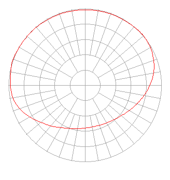 | ||||||||||||||||||
| Azimuth | Ratio | Azimuth | Ratio | Azimuth | Ratio | Azimuth | Ratio | ||||||||||||
| 0 | 0.983 | 10 | 0.984 | 20 | 0.988 | 30 | 0.989 | ||||||||||||
| 40 | 0.994 | 48 | 1.000 | 50 | 0.998 | 60 | 0.985 | ||||||||||||
| 70 | 0.955 | 80 | 0.911 | 90 | 0.849 | 100 | 0.784 | ||||||||||||
| 110 | 0.720 | 120 | 0.666 | 130 | 0.621 | 140 | 0.589 | ||||||||||||
| 150 | 0.568 | 160 | 0.557 | 170 | 0.554 | 180 | 0.561 | ||||||||||||
| 190 | 0.576 | 200 | 0.601 | 210 | 0.639 | 220 | 0.693 | ||||||||||||
| 230 | 0.753 | 240 | 0.831 | 250 | 0.908 | 260 | 0.957 | ||||||||||||
| 270 | 0.975 | 280 | 0.986 | 288 | 1.000 | 290 | 0.998 | ||||||||||||
| 300 | 0.991 | 310 | 0.988 | 320 | 0.987 | 330 | 0.983 | ||||||||||||
| 340 | 0.983 | 350 | 0.983 | ||||||||||||||||
Structure Registration Number 1037000 Structure Type: TOWER Registered To: MOORES RABBITHILL LLC Structure Address: Rabbit Hill Rd Holly Springs, GA County Name: Cherokee County ASR Issued: 07/11/2008 Date Built: 04/01/1989 Site Elevation: 311 m (1020 ft.) Structure Height: 151 m (495 ft.) Height Overall: 152 m (499 ft.) Overall Height AMSL: 463 m (1519 ft.) FAA Determination: 11/01/1988 FAA Study #: 88-ASO-1894-OE Paint & Light FAA Chapters: A2, H MEDIUM INTENSITY WHITE LIGHTS 34-09-14.0 N 84-30-44.0 W (NAD 83) 34-09-13.6 N 84-30-44.3 W (Converted to NAD 27) |
2203 Wynnton Road Columbus, GA 31902 Phone: 706-576-5360 Limited Liability Company | Title: Member Date: 12/11/2020 Application Certifier DAVIS BROADCASTING OF ATLANTA, L.L.C. Davis Broadcasting Of Atlanta, L.l.c. 2203 Wynnton Road Columbus, GA 31902 Applicant Scott Pippen, ESQ. Lerman Senter Pllc 2001 L Street, N.w. Suite 400 Washington, DC 20036 Kevin J. Youngers Youngers Colorado Broadcasting Llc 3004 70th Ave Greeley, CO 80634 TECHNICAL CONSULTANT | |||||||||||||||||