
FCCInfo.com
A Service of Cavell, Mertz & Associates, Inc.
(855) FCC-INFO
|
|
W224DG from 08/02/2004 |
|
|
||||||||||||||||
|
|
W224DG Channel: 224D 92.7 MHz Warwick, Rhode Island Service: FX - A translator or application for a translator. Facility ID: 140739 Fac. Service: FX Programming Delivery Method: Unspecified Status: License Application Accepted: 01/26/2021 Application Granted: 02/17/2021 File Number: -0000132660 License Expires: 04/01/2022 Application Type: License To Cover FCC Website Links: LMS Facility Details This Application Other W224DG Applications Other W224DG Applications in CDBS Including Superseded Applications Mailing Address Correspondence for W224DG Correspondence related to application -0000132660 Service Contour - Open Street Map or USGS Map (60 dBu) Service Contour - KML / Google Earth (60 dBu) Facility Type: FM STATION Class: D, A Noncommercial educational operating with no more than 10W Site Location: 41-48-29.8 N 71-28-17.9 W (NAD 83) Site Location: 41-48-29.4 N 71-28-19.7 W (Converted to NAD 27) Effective Radiated Power: 0.25 kW Transmitter Output Power: 0.505 kW Antenna Center HAAT: 0 m Antenna Center AMSL: 118 m (387 ft.) Antenna Center HAG: 36 m (118 ft.) Site Elevation: 82 m. (269 ft.) Height Overall*: 80.2 m (263 ft.) (* As Filed In This Application, may differ from ASR Data, Below.) Directional Antenna Antenna Make/Model: Shivley 6812B-2D-SS (0.5) Antenna ID: 127973 Polarization:
| ||||||||||||||||||
| Antenna Data for Antenna Id: 127973 W224DG FX File: -0000132660 Shivley - 6812B-2D-SS (0.5) Service: FX | 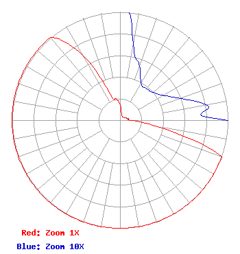 | ||||||||||||||||||
| Azimuth | Ratio | Azimuth | Ratio | Azimuth | Ratio | Azimuth | Ratio | ||||||||||||
| 0 | 0.144 | 10 | 0.071 | 20 | 0.053 | 30 | 0.039 | ||||||||||||
| 40 | 0.038 | 50 | 0.040 | 60 | 0.046 | 70 | 0.059 | ||||||||||||
| 80 | 0.081 | 90 | 0.100 | 100 | 0.350 | 110 | 1.000 | ||||||||||||
| 120 | 1.000 | 130 | 1.000 | 140 | 1.000 | 150 | 1.000 | ||||||||||||
| 160 | 1.000 | 170 | 1.000 | 180 | 1.000 | 190 | 1.000 | ||||||||||||
| 200 | 1.000 | 210 | 1.000 | 220 | 1.000 | 230 | 1.000 | ||||||||||||
| 240 | 1.000 | 250 | 1.000 | 260 | 1.000 | 270 | 1.000 | ||||||||||||
| 280 | 1.000 | 290 | 1.000 | 300 | 1.000 | 310 | 1.000 | ||||||||||||
| 320 | 1.000 | 330 | 0.700 | 340 | 0.240 | 350 | 0.200 | ||||||||||||
Structure Registration Number 1025228 Structure Type: TOWER Registered To: Pinnacle Towers LLC Structure Address: Falmouth St. Johnston, RI County Name: Providence County ASR Issued: 05/06/2016 Date Built: 01/01/1989 Site Elevation: 82 m (269 ft.) Structure Height: 79.5 m (261 ft.) Height Overall: 80.2 m (263 ft.) Overall Height AMSL: 162.2 m (532 ft.) FAA Determination: 07/20/2011 FAA Study #: 2011-ANE-1295-OE FAA Circular #: 70/7460-1G Paint & Light FAA Chapters: 3, 4, 5, 9 OM&L to remain the same as prior study = PAINT/RED LIGHTS 41-48-29.8 N 71-28-17.9 W (NAD 83) 41-48-29.4 N 71-28-19.7 W (Converted to NAD 27) |
8 Lawrence Road Derry, NH 03038 Phone: 603-437-9337 Corporation | Title: President Date: 01/26/2021 Application Certifier BLOUNT COMMUNICATIONS, INC. Blount Communications, Inc. 8 Lawrence Road Derry, NH 03038 Applicant JOSEPH C CHAUTIN, III Hardy, Carey, Chautin & Balkin, Llp 1080 West Causeway Approach Mandeville, LA 70471 ESQ SCOTT FYBUSH Fybush Media 92 Bonnie Brae Ave Rochester, NY 14618 TECHNICAL CONSULTANT | |||||||||||||||||