
FCCInfo.com
A Service of Cavell, Mertz & Associates, Inc.
(855) FCC-INFO
|
|
|
|
|
||||||||||||||||
|
|
WCNH Channel: 213A 90.5 MHz Concord, New Hampshire Service: FM - A full-service FM station or application. Facility ID: 62166 Fac. Service: FM Status: License Application Accepted: 02/12/2021 Application Granted: 02/18/2021 File Number: -0000136217 License Expires: 04/01/2022 Application Type: License To Cover FCC Website Links: LMS Facility Details This Application Other WCNH Applications Other WCNH Applications in CDBS Including Superseded Applications Mailing Address Correspondence for WCNH Correspondence related to application -0000136217 Service Contour - Open Street Map or USGS Map (60 dBu) Service Contour - KML / Google Earth (60 dBu) Public Inspection Files History Cards for WCNH Facility Type: NON-COMMERCIAL EDUC. FM Class: A, A Zone I; I-A; or II station; with 0.1kW-6kW ERP and a class contour distance <=28km Site Location: 43-12-53.0 N 71-34-26.0 W (NAD 83) Site Location: 43-12-52.7 N 71-34-27.7 W (Converted to NAD 27) Effective Radiated Power: 0.53 kW Transmitter Output Power: 0.485 kW Antenna Center HAAT: 100 m (328 ft.) Antenna Center AMSL: 238 m (781 ft.) Antenna Center HAG: 41 m (135 ft.) Site Elevation: 196.6 m. (645 ft.) Height Overall*: 61 m (200 ft.) (* As Filed In This Application, may differ from ASR Data, Below.) Directional Antenna Antenna Make/Model: SHIVELY 6810-1R-EF-DA,1 section Antenna ID: 0 Polarization: H | ||||||||||||||||||
| Antenna Data for Antenna Id: 0 WCNH FM File: -0000136217 SHIVELY - 6810-1R-EF-DA,1 section Service: FM | 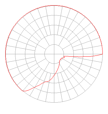 | ||||||||||||||||||
| Azimuth | Ratio | Azimuth | Ratio | Azimuth | Ratio | Azimuth | Ratio | ||||||||||||
| 0 | 1.000 | 10 | 1.000 | 20 | 1.000 | 30 | 1.000 | ||||||||||||
| 40 | 1.000 | 50 | 1.000 | 60 | 1.000 | 70 | 1.000 | ||||||||||||
| 80 | 1.000 | 90 | 1.000 | 100 | 0.281 | 110 | 0.224 | ||||||||||||
| 120 | 0.178 | 130 | 0.178 | 140 | 0.178 | 150 | 0.224 | ||||||||||||
| 160 | 0.281 | 170 | 0.354 | 180 | 0.446 | 190 | 0.562 | ||||||||||||
| 200 | 0.630 | 210 | 0.794 | 220 | 1.000 | 230 | 1.000 | ||||||||||||
| 240 | 1.000 | 250 | 1.000 | 260 | 1.000 | 270 | 1.000 | ||||||||||||
| 280 | 1.000 | 290 | 1.000 | 300 | 1.000 | 310 | 1.000 | ||||||||||||
| 320 | 1.000 | 330 | 1.000 | 340 | 1.000 | 350 | 1.000 | ||||||||||||
Structure Registration Number 1254888 Structure Type: TOWER Registered To: New Hampshire Public Radio Structure Address: Little Pond Road Concord, NH County Name: Merrimack County ASR Issued: 08/30/2006 Date Built: 12/15/2007 Site Elevation: 196.6 m (645 ft.) Structure Height: 61 m (200 ft.) Height Overall: 61 m (200 ft.) Overall Height AMSL: 257.6 m (845 ft.) FAA Determination: 01/01/1982 FAA Study #: 82-ANE-280-OE Paint & Light FAA Chapters: NONE 43-12-53.0 N 71-34-26.0 W (NAD 83) 43-12-52.7 N 71-34-27.7 W (Converted to NAD 27) |
2 Pillsbury Street 6th Floor Concord, NH 03301 Phone: 603-228-8910 Not-for-Profit | Title: Chief Financial Officer Date: 02/12/2021 Application Certifier ST. PAUL'S SCHOOL St. Paul's School 325 Pleasant Street Concord, NH 03301 Applicant Robert M Smith, Jr R.m. Smith Associates 10920b Crown Colony Drive Austin, TX 78747 TECHNICAL CONSULTANT MARK Van Bergh Mark Van Bergh Esquire 1625 S. Nelson St. Arlington, VA 22204 Legal Counsel | |||||||||||||||||