
FCCInfo.com
A Service of Cavell, Mertz & Associates, Inc.
(855) FCC-INFO
|
|
|
|
|
||||||||||||||||
|
|
KEUB-FM1 Channel: 227D 93.3 MHz Astoria, Oregon Service: FB - A booster station or application for a booster. Facility ID: 203309 Fac. Service: FB Programming Delivery Method: Unspecified Status: License Application Accepted: 02/12/2021 Application Granted: 02/16/2021 File Number: -0000136198 License Expires: 00/00/0000 Application Type: License To Cover FCC Website Links: LMS Facility Details This Application Other KEUB-FM1 Applications Other KEUB-FM1 Applications in CDBS Including Superseded Applications Mailing Address Correspondence for KEUB-FM1 Correspondence related to application -0000136198 Service Contour - Open Street Map or USGS Map (60 dBu) Service Contour - KML / Google Earth (60 dBu) Facility Type: FM STATION Class: D, A Noncommercial educational operating with no more than 10W Site Location: 46-11-15.2 N 123-50-20.6 W (NAD 83) Site Location: 46-11-15.8 N 123-50-16.1 W (Converted to NAD 27) Effective Radiated Power: 0.099 kW Horiz. ; 0 kW Vert. Antenna Center HAAT: 0 m Antenna Center AMSL: 72.3 m Horiz.; 0 m Vert. Antenna Center HAG: 5.5 m Horiz.; 0 m Vert. Site Elevation: 66.8 m. (219 ft.) Height Overall*: 7.6 m (25 ft.) (* As Filed In This Application, may differ from ASR Data, Below.) Directional Antenna Antenna Make/Model: SAM 2XSAM-137; 70&300 Antenna ID: 131774 Polarization: H
| ||||||||||||||||||
| Antenna Data for Antenna Id: 131774 KEUB-FM1 FB File: -0000136198 SAM - 2XSAM-137; 70&300 Service: FB | 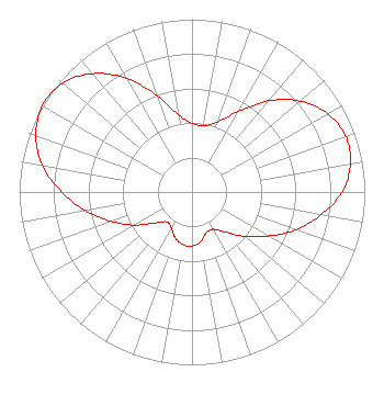 | ||||||||||||||||||
| Azimuth | Ratio | Azimuth | Ratio | Azimuth | Ratio | Azimuth | Ratio | ||||||||||||
| 0 | 0.398 | 10 | 0.391 | 20 | 0.430 | 30 | 0.536 | ||||||||||||
| 40 | 0.688 | 50 | 0.819 | 60 | 0.907 | 70 | 0.946 | ||||||||||||
| 80 | 0.932 | 90 | 0.868 | 100 | 0.758 | 110 | 0.639 | ||||||||||||
| 120 | 0.509 | 130 | 0.399 | 140 | 0.303 | 150 | 0.249 | ||||||||||||
| 160 | 0.249 | 170 | 0.292 | 180 | 0.313 | 190 | 0.309 | ||||||||||||
| 200 | 0.282 | 210 | 0.240 | 220 | 0.225 | 230 | 0.279 | ||||||||||||
| 240 | 0.382 | 250 | 0.496 | 260 | 0.625 | 270 | 0.755 | ||||||||||||
| 280 | 0.878 | 290 | 0.962 | 300 | 1.000 | 310 | 0.978 | ||||||||||||
| 320 | 0.895 | 330 | 0.760 | 340 | 0.594 | 350 | 0.453 | ||||||||||||
Structure Registration Number 1318425 Structure Type: LTOWER Structure Address: 390 Franklin Ave Astoria, OR County Name: Clatsop County ASR Issued: 02/11/2021 Date Built: 06/01/1991 Site Elevation: 66.8 m (219 ft.) Structure Height: 7.6 m (25 ft.) Height Overall: 7.6 m (25 ft.) Overall Height AMSL: 74.4 m (244 ft.) FAA Determination: 02/08/2021 FAA Study #: 2021-ANM-87-OE Paint & Light FAA Chapters: NONE 46-11-15.2 N 123-50-20.6 W (NAD 83) 46-11-15.8 N 123-50-16.1 W (Converted to NAD 27) |
2617 W Falls Ave Kennewick, WA 99336 Phone: 509-737-8762 Limited Liability Company | Title: President Date: 02/12/2021 Application Certifier RADIO BEAM, LLC Jacobs Radio Programming, Llc 2617 W Falls Ave Kennewick, WA 99336 Applicant ERIK C SWANSON, PE Hatfield & Dawson 9500 Greenwood Ave N Seattle, WA 98103 CONSULTING ENGINEER | |||||||||||||||||