
FCCInfo.com
A Service of Cavell, Mertz & Associates, Inc.
(855) FCC-INFO
|
|
|
|
|
||||||||||||||||
|
|
K272EK Channel: 272D 102.3 MHz San Antonio, Texas Service: FX - A translator or application for a translator. Facility ID: 143204 Fac. Service: FX Programming Delivery Method: Unspecified Status: License Application Accepted: 03/02/2021 Application Granted: 03/10/2021 File Number: -0000137483 License Expires: 08/01/2021 Application Type: License To Cover FCC Website Links: LMS Facility Details This Application Other K272EK Applications Other K272EK Applications in CDBS Including Superseded Applications Mailing Address Correspondence for K272EK Correspondence related to application -0000137483 Service Contour - Open Street Map or USGS Map (60 dBu) Service Contour - KML / Google Earth (60 dBu) Facility Type: FM STATION Class: D, A Noncommercial educational operating with no more than 10W Site Location: 29-25-42.0 N 98-29-33.0 W (NAD 83) Site Location: 29-25-41.2 N 98-29-31.9 W (Converted to NAD 27) Effective Radiated Power: 0.114 kW Transmitter Output Power: 0.279 kW Antenna Center HAAT: 69.2 m Horiz.; 0 m Vert. Antenna Center AMSL: 375.8 m (1233 ft.) Antenna Center HAG: 171 m (561 ft.) Site Elevation: 204.8 m. (672 ft.) Height Overall*: 169.8 m (557 ft.) (* As Filed In This Application, may differ from ASR Data, Below.) Directional Antenna Antenna Make/Model: Nicom BKG-77 Antenna ID: 89395 Polarization: H
| ||||||||||||||||||
| Antenna Data for Antenna Id: 89395 K272EK FX File: -0000137483 Nicom - BKG-77 Service: FX | 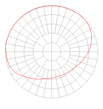 | ||||||||||||||||||
| Azimuth | Ratio | Azimuth | Ratio | Azimuth | Ratio | Azimuth | Ratio | ||||||||||||
| 0 | 0.983 | 10 | 0.988 | 20 | 0.988 | 30 | 0.992 | ||||||||||||
| 40 | 1.000 | 50 | 0.991 | 60 | 0.963 | 70 | 0.923 | ||||||||||||
| 80 | 0.862 | 90 | 0.797 | 100 | 0.731 | 110 | 0.676 | ||||||||||||
| 120 | 0.628 | 130 | 0.594 | 140 | 0.571 | 150 | 0.558 | ||||||||||||
| 160 | 0.553 | 170 | 0.558 | 180 | 0.571 | 190 | 0.594 | ||||||||||||
| 200 | 0.628 | 210 | 0.682 | 220 | 0.738 | 230 | 0.815 | ||||||||||||
| 240 | 0.897 | 250 | 0.953 | 260 | 0.973 | 270 | 0.983 | ||||||||||||
| 280 | 1.000 | 290 | 0.992 | 300 | 0.988 | 310 | 0.988 | ||||||||||||
| 320 | 0.983 | 330 | 0.983 | 340 | 0.983 | 350 | 0.983 | ||||||||||||
Structure Registration Number 1054137 Structure Type: BANT Registered To: Santa Clara Land Company, LTD Structure Address: 112 East Pecan Blvd. San Antonio, TX County Name: Bexar County ASR Issued: 03/31/2022 Date Built: 01/01/1998 Site Elevation: 204.8 m (672 ft.) Structure Height: 169.8 m (557 ft.) Height Overall: 169.8 m (557 ft.) Overall Height AMSL: 374.6 m (1229 ft.) FAA Determination: 05/11/1992 FAA Study #: 92-ASW-0244-OE Paint & Light FAA Chapters: NONE 29-25-42.0 N 98-29-33.0 W (NAD 83) 29-25-41.2 N 98-29-31.9 W (Converted to NAD 27) |
Corpus Christi, TX 78410 Phone: 361-774-4354 Individual | Title: Licensee Date: 03/02/2021 Application Certifier 11737 Nelon Dr. Corpus Christi, TX 78410 Applicant Darryl K DeLawder Delawder Communications, Inc. P.o Box 1095 Ashburn, VA 20146 President Christopher D. Imlay, Esq. Booth, Freret & Imlay, Llc 14356 Cape May Road Silver Spring, MD 20904 Communications Counsel | |||||||||||||||||