
FCCInfo.com
A Service of Cavell, Mertz & Associates, Inc.
(855) FCC-INFO
|
|
WZIP from 06/05/1989 |
|  |
|
|||||||||||||||
|
|
WZIP Channel: 201B 88.1 MHz Akron, Ohio Service: FM - A full-service FM station or application. Facility ID: 66613 Fac. Service: FM Status: License Application Accepted: 03/11/2021 Application Granted: 03/12/2021 File Number: -0000138839 License Expires: 10/01/2028 Application Type: Minor Modification FCC Website Links: LMS Facility Details This Application Other WZIP Applications Other WZIP Applications in CDBS Including Superseded Applications Mailing Address Correspondence for WZIP Correspondence related to application -0000138839 Service Contour - Open Street Map or USGS Map (60 dBu) Service Contour - KML / Google Earth (60 dBu) Public Inspection Files History Cards for WZIP Facility Type: NON-COMMERCIAL EDUC. FM Class: B, A Zone I or I-A station; with 25kW-50kW ERP and a class contour distance 39km-52km Site Location: 41-04-58.5 N 81-38-01.6 W (NAD 83) Site Location: 41-04-58.3 N 81-38-02.2 W (Converted to NAD 27) Effective Radiated Power: 7.5 kW Horiz. ; 7.35 kW Vert. Antenna Center HAAT: 250 m (820 ft.) Antenna Center AMSL: 570 m (1870 ft.) Antenna Center HAG: 229 m (751 ft.) Calculated Site Elevation: 341 m. (1119 ft.) Height Overall*: 282 m (925 ft.) (* As Filed In This Application, may differ from ASR Data, Below.) Directional Antenna Antenna Make/Model: Shively 6810-3D-DA Antenna ID: 15022 Polarization: | ||||||||||||||||||
| Antenna Data for Antenna Id: 15022 WZIP FM File: -0000138839 Shively - 6810-3D-DA Service: FM | 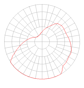 | ||||||||||||||||||
| Azimuth | Ratio | Azimuth | Ratio | Azimuth | Ratio | Azimuth | Ratio | ||||||||||||
| 0 | 0.260 | 10 | 0.325 | 20 | 0.400 | 30 | 0.500 | ||||||||||||
| 40 | 0.625 | 45 | 0.645 | 50 | 0.670 | 60 | 0.670 | ||||||||||||
| 70 | 0.670 | 80 | 0.700 | 90 | 0.740 | 100 | 0.780 | ||||||||||||
| 110 | 0.820 | 120 | 0.820 | 130 | 0.840 | 135 | 0.850 | ||||||||||||
| 140 | 0.860 | 150 | 1.000 | 160 | 1.000 | 170 | 1.000 | ||||||||||||
| 180 | 1.000 | 190 | 1.000 | 200 | 1.000 | 210 | 1.000 | ||||||||||||
| 220 | 1.000 | 230 | 1.000 | 236 | 1.000 | 240 | 0.925 | ||||||||||||
| 250 | 0.735 | 260 | 0.585 | 270 | 0.465 | 280 | 0.370 | ||||||||||||
| 290 | 0.295 | 300 | 0.235 | 310 | 0.190 | 315 | 0.178 | ||||||||||||
| 320 | 0.178 | 330 | 0.178 | 340 | 0.190 | 350 | 0.220 | ||||||||||||
Structure Registration Number 1018464 [ASR Heights Differ from WZIP Application] Structure Type: GTOWER Registered To: Northeastern Educational Television of Ohio, Inc. Structure Address: 2101 S Cleveland Massillon Rd Copley, OH County Name: Summit County ASR Issued: 05/22/2023 Date Built: 08/20/1996 Site Elevation: 341.4 m (1120 ft.) Structure Height: 266.4 m (874 ft.) Height Overall: 280.4 m (920 ft.) Overall Height AMSL: 621.8 m (2040 ft.) FAA Determination: 10/16/2019 FAA Study #: 2019-AGL-17116-OE FAA Circular #: 70/7460-1J Paint & Light FAA Chapters: 4, 7, 13 PRIOR STUDIES 97-AGL-0843-OE / 1998-AGL-2414-OE 41-04-58.5 N 81-38-01.6 W (NAD 83) 41-04-58.3 N 81-38-02.2 W (Converted to NAD 27) |
Wzip 302 Buchtel Common Akron, OH 44325 Phone: 330-972-7821 Government Entity | Title: Senior Vice President And Cfo Date: 03/11/2021 Application Certifier The University Of Akron Wzip 302 Buchtel Common Akron, OH 44325 Applicant Roy P Stype, III Carl E. Smith Consulting Engineers 2324 North Cleveland-massillon Road Bath, OH 44210-0807 Consulting Engineer Derek Teslik Gray Miller Persh Llp 2233 Wisconsin Ave., Nw Suite 226 Washington, DC 20007 | |||||||||||||||||
| |||||||||||||||||||