
FCCInfo.com
A Service of Cavell, Mertz & Associates, Inc.
(855) FCC-INFO
|
|
W296CX from 05/17/2004 |
|
|
||||||||||||||||
|
|
W296CX Channel: 296D 107.1 MHz Winder, Georgia Service: FX - A translator or application for a translator. Facility ID: 146792 Fac. Service: FX Programming Delivery Method: Unspecified Status: License Application Accepted: 03/15/2021 Application Granted: 04/07/2021 File Number: -0000139376 License Expires: 04/01/2028 Application Type: License To Cover FCC Website Links: LMS Facility Details This Application Other W296CX Applications Other W296CX Applications in CDBS Including Superseded Applications Mailing Address Correspondence for W296CX Correspondence related to application -0000139376 Service Contour - Open Street Map or USGS Map (60 dBu) Service Contour - KML / Google Earth (60 dBu) Facility Type: FM STATION Class: D, A Noncommercial educational operating with no more than 10W Site Location: 34-07-32.0 N 83-51-32.0 W (NAD 83) Site Location: 34-07-31.6 N 83-51-32.4 W (Converted to NAD 27) Effective Radiated Power: 0.25 kW Antenna Center HAAT: 0 m Antenna Center AMSL: 701.5 m (2302 ft.) Antenna Center HAG: 430.3 m (1412 ft.) Site Elevation: 271.2 m. (890 ft.) Height Overall*: 537.9 m (1765 ft.) (* As Filed In This Application, may differ from ASR Data, Below.) Directional Antenna Antenna Make/Model: Systems With Reliability Inc. FMEC/1 Antenna ID: 135157 Polarization: H
| ||||||||||||||||||
| Antenna Data for Antenna Id: 135157 W296CX FX File: -0000139376 Systems With Reliability Inc. - FMEC/1 Service: FX | 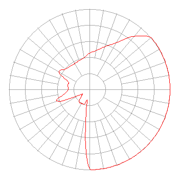 | ||||||||||||||||||
| Azimuth | Ratio | Azimuth | Ratio | Azimuth | Ratio | Azimuth | Ratio | ||||||||||||
| 0 | 0.450 | 10 | 0.490 | 20 | 0.565 | 30 | 0.670 | ||||||||||||
| 40 | 0.860 | 50 | 1.000 | 60 | 1.000 | 70 | 1.000 | ||||||||||||
| 80 | 1.000 | 90 | 1.000 | 100 | 1.000 | 110 | 1.000 | ||||||||||||
| 120 | 1.000 | 130 | 1.000 | 140 | 1.000 | 150 | 1.000 | ||||||||||||
| 160 | 1.000 | 170 | 1.000 | 180 | 0.986 | 190 | 0.200 | ||||||||||||
| 200 | 0.200 | 210 | 0.200 | 220 | 0.200 | 230 | 0.130 | ||||||||||||
| 240 | 0.130 | 250 | 0.424 | 260 | 0.312 | 270 | 0.263 | ||||||||||||
| 280 | 0.274 | 290 | 0.285 | 300 | 0.435 | 310 | 0.390 | ||||||||||||
| 320 | 0.375 | 330 | 0.370 | 340 | 0.380 | 350 | 0.400 | ||||||||||||
Structure Registration Number 1019528 Structure Type: TOWER Registered To: American Towers LLC Structure Address: 5510 Union Church Rd Flowery Branch, GA County Name: Hall County ASR Issued: 01/05/2021 Date Built: 08/17/1984 Site Elevation: 271.2 m (890 ft.) Structure Height: 515.1 m (1690 ft.) Height Overall: 537.9 m (1765 ft.) Overall Height AMSL: 809.1 m (2655 ft.) FAA Determination: 04/03/1997 FAA Study #: 97-ASO-0794-OE FAA Circular #: 70/7460-1J Paint & Light FAA Chapters: 4, 7, 13 34-07-32.0 N 83-51-32.0 W (NAD 83) 34-07-31.6 N 83-51-32.4 W (Converted to NAD 27) |
2004 Springview Trail Tucker, GA 30084 Phone: 404-929-0522 Limited Liability Company | Title: Managing Member Date: 03/15/2021 Application Certifier BARROW RADIO BROADCASTING LLC Barrow Radio Broadcasting Llc 2004 Springview Trail Tucker, GA 30084 Applicant Clifton G Moor Bromo Communications, Inc. Bromo Communications, Inc. 3600 Dallas Highway, Suite 230 - Pmb 164 Marietta, GA 30064 Technical Consultant Jeff Batten Barrow Radio Broadcasting, Llc 2004 Springview Trail Tucker, GA 30084 | |||||||||||||||||
| |||||||||||||||||||