
FCCInfo.com
A Service of Cavell, Mertz & Associates, Inc.
(855) FCC-INFO
|
|
|
|  |
|
|||||||||||||||
|
|
WJWD Channel: 212B1 90.3 MHz Marshall, Wisconsin Service: FM - A full-service FM station or application. Facility ID: 93445 Fac. Service: FM Status: Construction Permit Application Accepted: 04/26/2021 Application Granted: 06/29/2021 File Number: -0000143993 WJWD CP Expires: 06/29/2024 Application Type: Minor Modification FCC Website Links: LMS Facility Details This Application Other WJWD Applications Other WJWD Applications in CDBS Including Superseded Applications Mailing Address Correspondence for WJWD Correspondence related to application -0000143993 Service Contour - Open Street Map or USGS Map (60 dBu) Service Contour - KML / Google Earth (60 dBu) Public Inspection Files Facility Type: NON-COMMERCIAL EDUC. FM Class: B1, A Zone I or I-A station; with 6kW-25kW ERP and a class contour distance 28km-39km Site Location: 43-20-40.0 N 89-06-10.0 W (NAD 83) Site Location: 43-20-40.0 N 89-06-09.6 W (Converted to NAD 27) Effective Radiated Power: 9.7 kW Antenna Center HAAT: 95 m (312 ft.) Antenna Center AMSL: 380 m (1247 ft.) Antenna Center HAG: 105 m (344 ft.) Site Elevation: 275 m. (902 ft.) Height Overall*: 113 m (371 ft.) (* As Filed In This Application, may differ from ASR Data, Below.) Directional Antenna Antenna Make/Model: None Antenna ID: 38328 Polarization:
| ||||||||||||||||||
| Antenna Data for Antenna Id: 38328 WJWD FM File: -0000143993 None - Service: FM | 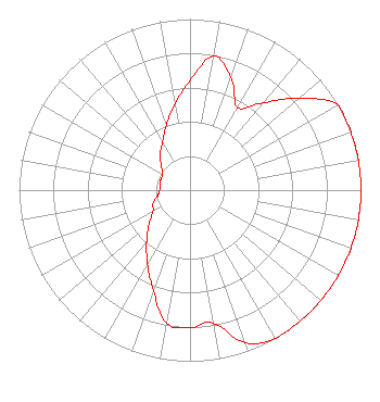 | ||||||||||||||||||
| Azimuth | Ratio | Azimuth | Ratio | Azimuth | Ratio | Azimuth | Ratio | ||||||||||||
| 0 | 0.642 | 10 | 0.795 | 20 | 0.700 | 30 | 0.556 | ||||||||||||
| 40 | 0.667 | 50 | 0.834 | 60 | 1.000 | 70 | 1.000 | ||||||||||||
| 80 | 1.000 | 90 | 1.000 | 100 | 1.000 | 110 | 1.000 | ||||||||||||
| 120 | 1.000 | 130 | 1.000 | 140 | 1.000 | 150 | 1.000 | ||||||||||||
| 160 | 0.951 | 170 | 0.788 | 180 | 0.806 | 190 | 0.788 | ||||||||||||
| 200 | 0.626 | 210 | 0.497 | 220 | 0.395 | 230 | 0.314 | ||||||||||||
| 240 | 0.250 | 250 | 0.230 | 260 | 0.193 | 270 | 0.178 | ||||||||||||
| 280 | 0.178 | 290 | 0.182 | 300 | 0.185 | 310 | 0.218 | ||||||||||||
| 320 | 0.273 | 330 | 0.322 | 340 | 0.405 | 350 | 0.510 | ||||||||||||
Structure Registration Number 1224263 Structure Type: TOWER Registered To: Calvary Radio Network, Inc. Structure Address: N Side Of Sr 60, 7 Km W Of Columbus, Wi Columbua, WI County Name: Columbia County ASR Issued: 04/23/2013 Date Built: 02/13/2003 Site Elevation: 275 m (902 ft.) Structure Height: 113 m (371 ft.) Height Overall: 113 m (371 ft.) Overall Height AMSL: 388 m (1273 ft.) FAA Determination: 02/27/2001 FAA Study #: 01-AGL-0110-OE FAA Circular #: 70/7460-1K Paint & Light FAA Chapters: 3, 4, 5, 12 PRIOR STUDY 99-AGL-1735-OE 43-20-40.0 N 89-06-10.0 W (NAD 83) 43-20-40.0 N 89-06-09.6 W (Converted to NAD 27) |
P O Box 431 Valparaiso, IN 46384 Phone: 219-548-5800 Private Not-for-Profit Educational Institution | Title: President Date: 04/26/2021 Application Certifier CALVARY RADIO NETWORK, INC. Calvary Radio Network, Inc. P O Box 431 Valparaiso, IN 46384 Applicant Matthew H. McCormick, Esq Fletcher, Heald & Hildreth, Plc 1300 N 17th Street 11th Floor Arlington, VA 22209 Robert Moore Rcm Engineering 1908 Sweetbriar Goshen, IN 46528 Consultant | |||||||||||||||||
| |||||||||||||||||||