
FCCInfo.com
A Service of Cavell, Mertz & Associates, Inc.
(855) FCC-INFO
|
|
WMXD from 12/28/1987 WMXD from 05/15/1986 |
|
|
||||||||||||||||
|
|
WMXD Channel: 222B 92.3 MHz Detroit, Michigan Service: FS - A full service FM station auxiliary transmitting antenna or application. Facility ID: 59596 Fac. Service: FM Analog & Digital Status: Construction Permit Application Accepted: 05/11/2021 Application Granted: 07/06/2021 File Number: -0000145030 WMXD CP Expires: 07/06/2024 Application Type: Construction Permit FCC Website Links: LMS Facility Details This Application Other WMXD Applications Other WMXD Applications in CDBS Including Superseded Applications Mailing Address Correspondence for WMXD Correspondence related to application -0000145030 Service Contour - Open Street Map or USGS Map (54 dBu) Service Contour - KML / Google Earth (54 dBu) Public Inspection Files History Cards for WMXD Facility Type: FM STATION Class: B, A Zone I or I-A station; with 25kW-50kW ERP and a class contour distance 39km-52km Site Location: 42-21-06.0 N 83-03-48.0 W (NAD 83) Site Location: 42-21-05.9 N 83-03-48.3 W (Converted to NAD 27) Effective Radiated Power: 41 kW Antenna Center HAAT: 135 m (443 ft.) Antenna Center AMSL: 320 m (1050 ft.) Antenna Center HAG: 129.5 m (425 ft.) Site Elevation: 190.5 m. (625 ft.) Height Overall*: 172.5 m (566 ft.) (* As Filed In This Application, may differ from ASR Data, Below.) Directional Antenna Antenna Make/Model: None Antenna ID: 69-2019-08-06 Polarization: | ||||||||||||||||||
| Antenna Data for Antenna Id: 69-2019-08-06 WMXD FS File: -0000145030 None - Service: FS | 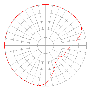 | ||||||||||||||||||
| Azimuth | Ratio | Azimuth | Ratio | Azimuth | Ratio | Azimuth | Ratio | ||||||||||||
| 0 | 1.000 | 10 | 1.000 | 20 | 1.000 | 30 | 1.000 | ||||||||||||
| 40 | 1.000 | 50 | 1.000 | 60 | 1.000 | 70 | 0.920 | ||||||||||||
| 80 | 0.788 | 90 | 0.651 | 100 | 0.552 | 110 | 0.521 | ||||||||||||
| 120 | 0.509 | 130 | 0.439 | 140 | 0.462 | 150 | 0.488 | ||||||||||||
| 160 | 0.614 | 170 | 0.772 | 180 | 0.929 | 190 | 1.000 | ||||||||||||
| 200 | 1.000 | 210 | 1.000 | 220 | 1.000 | 230 | 1.000 | ||||||||||||
| 240 | 1.000 | 250 | 1.000 | 260 | 1.000 | 270 | 1.000 | ||||||||||||
| 280 | 1.000 | 290 | 1.000 | 300 | 1.000 | 310 | 1.000 | ||||||||||||
| 320 | 1.000 | 330 | 1.000 | 340 | 1.000 | 350 | 1.000 | ||||||||||||
Structure Registration Number 1007201 Structure Type: TOWER Registered To: WAYNE STATE UNIVERSITY Structure Address: 105 W Canfield Detroit, MI County Name: Wayne County ASR Issued: 01/25/1997 Date Built: 01/22/1996 Site Elevation: 190.5 m (625 ft.) Structure Height: 171.3 m (562 ft.) Height Overall: 172.5 m (566 ft.) Overall Height AMSL: 363 m (1191 ft.) FAA Determination: 10/13/1995 FAA Study #: 95-AGL-2069-OE FAA Circular #: 70/7460-1H Paint & Light FAA Chapters: 4, 9, 13 42-21-06.0 N 83-03-48.0 W (NAD 83) 42-21-05.9 N 83-03-48.3 W (Converted to NAD 27) |
7136 S. Yale Avenue Suite 501 Tulsa, OK 74136 Phone: 918-664-4581 Limited Liability Company | Title: Svp, Re, Facilities And Corp Development Date: 05/11/2021 Application Certifier IHM LICENSES, LLC Ihm Licenses, Llc 7136 S. Yale Avenue Suite 501 Tulsa, OK 74136 Applicant Marissa G Repp Repp Law Firm 1629 K Street, Nw Suite 300 Washington, DC 20006-1631 Counsel William Jeffrey Reynolds Du Treil, Lundin & Rackley, Inc. 5120 Station Way Sarasota, FL 34233-3221 Technical Consultant Troy Langham Ihm Licenses, Llc 7136 S. Yale Avenue Suite 501 Tulsa, OK 74136 VP, Technical Regulatory Affairs | |||||||||||||||||