
FCCInfo.com
A Service of Cavell, Mertz & Associates, Inc.
(855) FCC-INFO
|
|
|
|
|
||||||||||||||||
|
|
W223DK Channel: 223D 92.5 MHz Louisville, Kentucky Service: FX - A translator or application for a translator. Facility ID: 203138 Fac. Service: FX Programming Delivery Method: Unspecified Status: License Application Accepted: 06/17/2021 Application Granted: 07/22/2021 File Number: -0000150356 License Expires: 08/01/2028 Application Type: License To Cover FCC Website Links: LMS Facility Details This Application Other W223DK Applications Other W223DK Applications in CDBS Including Superseded Applications Mailing Address Correspondence for W223DK Correspondence related to application -0000150356 Service Contour - Open Street Map or USGS Map (60 dBu) Service Contour - KML / Google Earth (60 dBu) Facility Type: FM STATION Class: D, A Noncommercial educational operating with no more than 10W Site Location: 38-28-55.0 N 85-37-33.0 W (NAD 83) Site Location: 38-28-54.8 N 85-37-33.1 W (Converted to NAD 27) Effective Radiated Power: 0.25 kW Antenna Center HAAT: 0 m Antenna Center AMSL: 279 m (915 ft.) Antenna Center HAG: 122 m (400 ft.) Site Elevation: 157 m. (515 ft.) Height Overall*: 125 m (410 ft.) (* As Filed In This Application, may differ from ASR Data, Below.) Directional Antenna Antenna Make/Model: Electronics Research Inc. 100A-4F-HW Antenna ID: 132795 Polarization: H
| ||||||||||||||||||
| Antenna Data for Antenna Id: 132795 W223DK FX File: -0000150356 Electronics Research Inc. - 100A-4F-HW Service: FX | 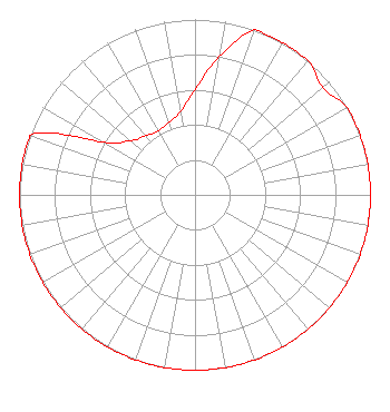 | ||||||||||||||||||
| Azimuth | Ratio | Azimuth | Ratio | Azimuth | Ratio | Azimuth | Ratio | ||||||||||||
| 0 | 0.600 | 10 | 0.800 | 20 | 1.000 | 30 | 1.000 | ||||||||||||
| 40 | 1.000 | 50 | 0.950 | 60 | 1.000 | 70 | 1.000 | ||||||||||||
| 80 | 1.000 | 90 | 1.000 | 100 | 1.000 | 110 | 1.000 | ||||||||||||
| 120 | 1.000 | 130 | 1.000 | 140 | 1.000 | 150 | 1.000 | ||||||||||||
| 160 | 1.000 | 170 | 1.000 | 180 | 1.000 | 190 | 1.000 | ||||||||||||
| 200 | 1.000 | 210 | 1.000 | 220 | 1.000 | 230 | 1.000 | ||||||||||||
| 240 | 1.000 | 250 | 1.000 | 260 | 1.000 | 270 | 1.000 | ||||||||||||
| 280 | 1.000 | 290 | 1.000 | 300 | 0.600 | 310 | 0.480 | ||||||||||||
| 320 | 0.440 | 330 | 0.420 | 340 | 0.440 | 350 | 0.480 | ||||||||||||
Structure Registration Number 1029665 Structure Type: TOWER Registered To: NEW ALBANY BROADCASTING CO INC DBA = WLVX Structure Address: 3913 Tunnel Mill Rd Charlestown, IN County Name: Clark County ASR Issued: 09/23/1997 Date Built: 08/01/1997 Site Elevation: 157 m (515 ft.) Structure Height: 124.1 m (407 ft.) Height Overall: 125 m (410 ft.) Overall Height AMSL: 282 m (925 ft.) FAA Determination: 07/06/1995 FAA Study #: 95-AGL-2440-OE FAA Circular #: 70/7460-1J Paint & Light FAA Chapters: 3, 4, 5, 13 38-28-55.0 N 85-37-33.0 W (NAD 83) 38-28-54.8 N 85-37-33.1 W (Converted to NAD 27) |
P O Box 2623 Clarksville, IN 47131 Phone: 502-584-2400 Corporation | Title: President Date: 06/17/2021 Application Certifier NEW ALBANY BROADCASTING CO., INC. New Albany Broadcasting Co., Inc. P O Box 2623 Clarksville, IN 47131 Applicant Peter Charles Boyce New Albany Broadcasting Co., Inc. 410 Mt. Tabor Road New Albany, IN 47150 President David Brian Smith, Sr New Albany Broadcasting Co., Inc. 220 Potters Lane Clarksville, IN 47129 Co-Owner Mark D Humphrey Mark D. Humphrey Exton, PA 19341 TECHNICAL CONSULTANT | |||||||||||||||||