
FCCInfo.com
A Service of Cavell, Mertz & Associates, Inc.
(855) FCC-INFO
|
|
|
|  |
|
|||||||||||||||
|
|
KXWT Channel: 217C2 91.3 MHz Odessa, Texas Service: FM - A full-service FM station or application. Facility ID: 50038 Fac. Service: FM Status: License Application Accepted: 07/09/2021 Application Granted: 06/23/2022 File Number: -0000152193 License Expires: 08/01/2029 Application Type: License To Cover FCC Website Links: LMS Facility Details This Application Other KXWT Applications Other KXWT Applications in CDBS Including Superseded Applications Mailing Address Correspondence for KXWT Correspondence related to application -0000152193 Service Contour - Open Street Map or USGS Map (60 dBu) Service Contour - KML / Google Earth (60 dBu) Public Inspection Files History Cards for KXWT Facility Type: NON-COMMERCIAL EDUC. FM Class: C2, A Zone II station; with 25kW-50kW ERP and a class contour distance 39km-52km Site Location: 32-02-54.6 N 102-18-05.6 W (NAD 83) Site Location: 32-02-54.2 N 102-18-04.1 W (Converted to NAD 27) Effective Radiated Power: 40 kW Transmitter Output Power: 3.4 kW Antenna Center HAAT: 111 m (364 ft.) Antenna Center AMSL: 1000 m (3281 ft.) Antenna Center HAG: 108 m (354 ft.) Site Elevation: 891.5 m. (2925 ft.) Height Overall*: 146.3 m (480 ft.) (* As Filed In This Application, may differ from ASR Data, Below.) Directional Antenna Antenna Make/Model: Propagation System Inc FMR-6C-DA Antenna ID: 106630 Polarization:
| ||||||||||||||||||
| Antenna Data for Antenna Id: 106630 KXWT FM File: -0000152193 Propagation System Inc - FMR-6C-DA Service: FM | 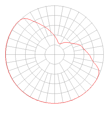 | ||||||||||||||||||
| Azimuth | Ratio | Azimuth | Ratio | Azimuth | Ratio | Azimuth | Ratio | ||||||||||||
| 0 | 0.380 | 10 | 0.300 | 20 | 0.242 | 30 | 0.251 | ||||||||||||
| 40 | 0.316 | 50 | 0.375 | 60 | 0.444 | 70 | 0.556 | ||||||||||||
| 80 | 0.610 | 90 | 0.700 | 100 | 0.794 | 110 | 0.961 | ||||||||||||
| 120 | 1.000 | 130 | 1.000 | 140 | 1.000 | 150 | 1.000 | ||||||||||||
| 160 | 1.000 | 170 | 1.000 | 180 | 1.000 | 190 | 1.000 | ||||||||||||
| 200 | 1.000 | 210 | 1.000 | 220 | 1.000 | 230 | 1.000 | ||||||||||||
| 240 | 1.000 | 250 | 1.000 | 260 | 1.000 | 270 | 1.000 | ||||||||||||
| 280 | 1.000 | 290 | 1.000 | 300 | 1.000 | 310 | 1.000 | ||||||||||||
| 320 | 0.954 | 330 | 0.758 | 340 | 0.602 | 350 | 0.478 | ||||||||||||
Structure Registration Number 1053974 Structure Type: GTOWER Registered To: American Towers LLC Structure Address: 16841 Derby Ave Gardendale, TX County Name: Ector County ASR Issued: 01/05/2021 Date Built: 01/01/1981 Site Elevation: 891.5 m (2925 ft.) Structure Height: 143.9 m (472 ft.) Height Overall: 146.3 m (480 ft.) Overall Height AMSL: 1037.8 m (3405 ft.) FAA Determination: 08/16/2018 FAA Study #: 2018-ASW-12027-OE FAA Circular #: 70/7460-1L Paint & Light FAA Chapters: 4, 8, 12 OM&L to remain the same as original issue date 08/16/2018 = A MED-DUAL SYSTEM 32-02-54.6 N 102-18-05.6 W (NAD 83) 32-02-54.2 N 102-18-04.1 W (Converted to NAD 27) |
111 S. Highland Avenue P.o. Box 238 Marfa, TX 79843 Phone: 432-729-4578 Not-for-Profit | Title: Executive Director, Marfa Public Radio Date: 07/09/2021 Application Certifier MARFA PUBLIC RADIO Marfa Public Radio 111 S. Highland Avenue P.o. Box 238 Marfa, TX 79843 Applicant ERNEST SANCHEZ The Sanchez Law Firm P.c. 1629 K St. Nw, Suite 300 Washington, DC 20006 Bert Goldman Goldman Engineering Mgmt., Inc 560 Perkins Way Auburn, CA 95603 TECHNICAL CONSULTANT | |||||||||||||||||
| |||||||||||||||||||