
FCCInfo.com
A Service of Cavell, Mertz & Associates, Inc.
(855) FCC-INFO
|
|
W232DY from 09/01/2021 W232DY from 06/23/2014 W232DY from 12/12/2003 W232DY from 02/06/2003 W232DY from 06/02/1994 |
|
|
||||||||||||||||
|
|
W232DY Channel: 232D 94.3 MHz Lawrenceburg, Tennessee Service: FX - A translator or application for a translator. Facility ID: 53668 Fac. Service: FX Programming Delivery Method: Unspecified Status: License Application Accepted: 07/19/2021 Application Granted: 09/01/2021 File Number: -0000153265 License Expires: 08/01/2028 Application Type: License To Cover FCC Website Links: LMS Facility Details This Application Other W232DY Applications Other W232DY Applications in CDBS Including Superseded Applications Mailing Address Correspondence for W232DY Correspondence related to application -0000153265 Service Contour - Open Street Map or USGS Map (60 dBu) Service Contour - KML / Google Earth (60 dBu) Facility Type: FM STATION Class: D, A Noncommercial educational operating with no more than 10W Site Location: 35-15-18.3 N 87-19-30.1 W (NAD 83) Site Location: 35-15-18.0 N 87-19-30.0 W (Converted to NAD 27) Effective Radiated Power: 0.25 kW Transmitter Output Power: 0.71 kW Antenna Center HAAT: 108.3 m Horiz.; 0 m Vert. Antenna Center AMSL: 385.4 m (1264 ft.) Antenna Center HAG: 105 m (344 ft.) Site Elevation: 280.4 m. (920 ft.) Height Overall*: 106.4 m (349 ft.) (* As Filed In This Application, may differ from ASR Data, Below.) Directional Antenna Antenna Make/Model: NICOM BKG77 Antenna ID: 105171 Polarization: H
| ||||||||||||||||||
| Antenna Data for Antenna Id: 105171 W232DY FX File: -0000153265 NICOM - BKG77 Service: FX | 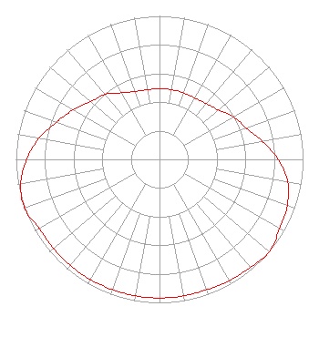 | ||||||||||||||||||
| Azimuth | Ratio | Azimuth | Ratio | Azimuth | Ratio | Azimuth | Ratio | ||||||||||||
| 0 | 0.493 | 10 | 0.493 | 20 | 0.493 | 30 | 0.493 | ||||||||||||
| 40 | 0.507 | 50 | 0.536 | 60 | 0.596 | 70 | 0.641 | ||||||||||||
| 80 | 0.728 | 90 | 0.826 | 100 | 0.908 | 110 | 0.947 | ||||||||||||
| 120 | 0.966 | 130 | 1.000 | 140 | 0.984 | 150 | 0.976 | ||||||||||||
| 160 | 0.966 | 170 | 0.966 | 180 | 0.966 | 190 | 0.966 | ||||||||||||
| 200 | 0.966 | 210 | 0.966 | 220 | 0.966 | 230 | 0.966 | ||||||||||||
| 240 | 0.966 | 250 | 1.000 | 260 | 0.982 | 270 | 0.927 | ||||||||||||
| 280 | 0.852 | 290 | 0.762 | 300 | 0.692 | 310 | 0.627 | ||||||||||||
| 320 | 0.591 | 330 | 0.536 | 340 | 0.504 | 350 | 0.493 | ||||||||||||
Structure Registration Number 1220842 Structure Type: Structure Address: 1212 N Locust Ave Lawrenceburg, TN County Name: Lawrence County ASR Issued: 04/15/2010 Date Built: 12/18/2000 Site Elevation: 280.4 m (920 ft.) Structure Height: 106.4 m (349 ft.) Height Overall: 106.4 m (349 ft.) Overall Height AMSL: 386.8 m (1269 ft.) FAA Determination: 04/14/2010 FAA Study #: 2010-ASO-1418-OE Paint & Light FAA Chapters: A1, H PRIOR STUDY 2000-ASO-4343-OE 35-15-18.3 N 87-19-30.1 W (NAD 83) 35-15-18.0 N 87-19-30.0 W (Converted to NAD 27) |
Lawrenceburg, TN 38464 Phone: 931-629-7713 Individual | Title: Applicant Date: 07/19/2021 Application Certifier PROSPECT COMM. 34 Springdale Rd Lawrenceburg, TN 38464 Applicant ROGER WRIGHT Roger Wright Dba Prospectcommunicationsr 1212 N. Locust Ave. Lawrenceburg, TN 38464 APPLICANT ROGER WRIGHT Prospect Comm. 1212 N. Locust Ave. Lawrenceburg, TN 38464 APPLICANT | |||||||||||||||||