
FCCInfo.com
A Service of Cavell, Mertz & Associates, Inc.
(855) FCC-INFO
|
|
|
|  |
|
|||||||||||||||
|
|
KGNU-FM Channel: 203C2 88.5 MHz Boulder, Colorado Service: FM - A full-service FM station or application. Facility ID: 6512 Fac. Service: FM Analog & Digital Status: Construction Permit Application Accepted: 08/16/2021 Application Granted: 01/12/2022 File Number: -0000157412 KGNU-FM CP Expires: 01/12/2025 Application Type: Minor Modification FCC Website Links: LMS Facility Details This Application Other KGNU-FM Applications Other KGNU-FM Applications in CDBS Including Superseded Applications Mailing Address Correspondence for KGNU-FM Correspondence related to application -0000157412 Service Contour - Open Street Map or USGS Map (60 dBu) Service Contour - KML / Google Earth (60 dBu) Public Inspection Files History Cards for KGNU-FM Facility Type: NON-COMMERCIAL EDUC. FM Class: C2, A Zone II station; with 25kW-50kW ERP and a class contour distance 39km-52km Site Location: 40-05-57.0 N 104-54-03.2 W (NAD 83) Site Location: 40-05-57.1 N 104-54-01.3 W (Converted to NAD 27) Effective Radiated Power: 6.5 kW Antenna Center HAAT: 339 m (1112 ft.) Antenna Center AMSL: 1860 m (6102 ft.) Antenna Center HAG: 308 m (1010 ft.) Site Elevation: 1551.4 m. (5090 ft.) Height Overall*: 352.9 m (1158 ft.) (* As Filed In This Application, may differ from ASR Data, Below.) Directional Antenna Antenna Make/Model: None Antenna ID: 1006063 Polarization:
| ||||||||||||||||||
| Antenna Data for Antenna Id: 1006063 KGNU-FM FM File: -0000157412 None - Service: FM | 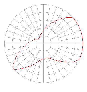 | ||||||||||||||||||
| Azimuth | Ratio | Azimuth | Ratio | Azimuth | Ratio | Azimuth | Ratio | ||||||||||||
| 0 | 0.342 | 10 | 0.431 | 20 | 0.543 | 30 | 0.683 | ||||||||||||
| 40 | 0.860 | 50 | 1.000 | 60 | 1.000 | 70 | 1.000 | ||||||||||||
| 80 | 1.000 | 90 | 1.000 | 100 | 1.000 | 110 | 1.000 | ||||||||||||
| 120 | 0.917 | 130 | 0.728 | 140 | 0.579 | 150 | 0.460 | ||||||||||||
| 160 | 0.390 | 170 | 0.375 | 180 | 0.390 | 190 | 0.425 | ||||||||||||
| 200 | 0.520 | 210 | 0.654 | 220 | 0.823 | 230 | 1.000 | ||||||||||||
| 240 | 0.841 | 250 | 0.668 | 260 | 0.530 | 270 | 0.421 | ||||||||||||
| 280 | 0.334 | 290 | 0.266 | 300 | 0.237 | 310 | 0.188 | ||||||||||||
| 320 | 0.188 | 330 | 0.192 | 340 | 0.242 | 350 | 0.272 | ||||||||||||
Structure Registration Number 1254146 Structure Type: GTOWER Registered To: American Towers LLC Structure Address: 6870 Weld County Rd 17 (282680) Fort Lupton, CO County Name: Weld County ASR Issued: 08/09/2021 Date Built: 07/14/2016 Site Elevation: 1551.4 m (5090 ft.) Structure Height: 306.9 m (1007 ft.) Height Overall: 352.9 m (1158 ft.) Overall Height AMSL: 1904.3 m (6248 ft.) FAA Determination: 08/05/2021 FAA Study #: 2021-ANM-5069-OE FAA Circular #: 70/7460-1K Paint & Light FAA Chapters: 4, 9, 12 PRIOR STUDY 2016-ANM-500-OE 40-05-57.0 N 104-54-03.2 W (NAD 83) 40-05-57.1 N 104-54-01.3 W (Converted to NAD 27) |
4700 Walnut Street Boulder, CO 80301 Phone: 303-449-4885 Not-for-Profit | Title: Board Chair Date: 08/16/2021 Application Certifier Boulder Community Broadcast Association, Inc. 4700 Walnut Street Boulder, CO 80301 Applicant Melodie A. Virtue Foster Garvey Pc 1000 Potomac St., Nw Suite 200 Washington, DC 20007 FCC Counsel Bert Goldman Goldman Engineering Management 560 Perkins Way Auburn, CA 95603 Technical Consultant | |||||||||||||||||
| |||||||||||||||||||