
FCCInfo.com
A Service of Cavell, Mertz & Associates, Inc.
(855) FCC-INFO
|
|
K201IY from 08/27/2021 K201IY from 02/09/2021 K201IY from 02/06/2018 K201IY from 07/12/2000 |
|
|
||||||||||||||||
|
|
K201IY Channel: 201D 88.1 MHz Houston, Texas Service: FX - A translator or application for a translator. Facility ID: 122072 Fac. Service: FX Programming Delivery Method: Unspecified Status: License Application Accepted: 08/16/2021 Application Granted: 08/27/2021 File Number: -0000157407 License Expires: 08/01/2029 Application Type: License To Cover FCC Website Links: LMS Facility Details This Application Other K201IY Applications Other K201IY Applications in CDBS Including Superseded Applications Mailing Address Correspondence for K201IY Correspondence related to application -0000157407 Service Contour - Open Street Map or USGS Map (60 dBu) Service Contour - KML / Google Earth (60 dBu) Facility Type: NON-COMMERCIAL EDUC. FM Class: D, A Noncommercial educational operating with no more than 10W Site Location: 29-33-45.2 N 95-30-35.9 W (NAD 83) Site Location: 29-33-44.4 N 95-30-35.1 W (Converted to NAD 27) Effective Radiated Power: 0.001 kW Antenna Center HAAT: 0 m Antenna Center AMSL: 571.6 m (1875 ft.) Antenna Center HAG: 549 m (1801 ft.) Site Elevation: 22.6 m. (74 ft.) Height Overall*: 601.7 m (1974 ft.) (* As Filed In This Application, may differ from ASR Data, Below.) Directional Antenna Antenna Make/Model: Nicom BKG77 Antenna ID: 1005767 Polarization: H
| ||||||||||||||||||
| Antenna Data for Antenna Id: 1005767 K201IY FX File: -0000157407 Nicom - BKG77 Service: FX | 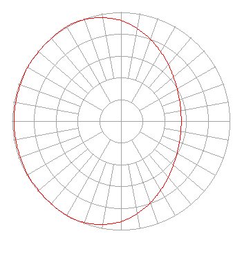 | ||||||||||||||||||
| Azimuth | Ratio | Azimuth | Ratio | Azimuth | Ratio | Azimuth | Ratio | ||||||||||||
| 0 | 0.923 | 10 | 0.862 | 20 | 0.797 | 30 | 0.731 | ||||||||||||
| 40 | 0.676 | 50 | 0.628 | 60 | 0.594 | 70 | 0.571 | ||||||||||||
| 80 | 0.558 | 90 | 0.553 | 100 | 0.558 | 110 | 0.571 | ||||||||||||
| 120 | 0.594 | 130 | 0.628 | 140 | 0.676 | 150 | 0.731 | ||||||||||||
| 160 | 0.797 | 170 | 0.862 | 180 | 0.923 | 190 | 0.963 | ||||||||||||
| 200 | 0.991 | 210 | 1.000 | 220 | 0.992 | 230 | 0.988 | ||||||||||||
| 240 | 0.988 | 250 | 0.983 | 260 | 0.983 | 270 | 0.983 | ||||||||||||
| 280 | 0.983 | 290 | 0.983 | 300 | 0.988 | 310 | 0.988 | ||||||||||||
| 320 | 0.992 | 330 | 1.000 | 340 | 0.991 | 350 | 0.963 | ||||||||||||
Structure Registration Number 1059622 Structure Type: GTOWER Registered To: American Towers LLC Structure Address: 2945 Senior Rd (30285 / Missouri City) Missouri City, TX County Name: Fort Bend County ASR Issued: 11/16/2022 Date Built: 08/30/2000 Site Elevation: 22.6 m (74 ft.) Structure Height: 562.1 m (1844 ft.) Height Overall: 601.7 m (1974 ft.) Overall Height AMSL: 624.3 m (2048 ft.) FAA Determination: 11/08/2022 FAA Study #: 2021-ASW-19989-OE FAA Circular #: 70/7460-1K Paint & Light FAA Chapters: 4, 7, 12 OM&L to remain the same as prior study = 24-HR HI-STROBES 29-33-45.2 N 95-30-35.9 W (NAD 83) 29-33-44.4 N 95-30-35.1 W (Converted to NAD 27) |
1600 Pasadena Blvd. Pasadena, TX 77502 Phone: 713-516-0521 Not-for-Profit | Title: President Date: 08/16/2021 Application Certifier CENTRO CRISTIANO DE VIDA ETERNA Centro Cristiano De Vida Eterna 8230 Antoine Dr. Houston, TX 77088 Applicant Dan J Alpert The Law Office Of Dan J. Alpert 2120 N. 21st Rd. Arlington, VA 22201 Darryl K DeLawder Delawder Communications, Inc. P.o Box 1095 Ashburn, VA 20146 President | |||||||||||||||||