
FCCInfo.com
A Service of Cavell, Mertz & Associates, Inc.
(855) FCC-INFO
|
|
WSIS from 05/12/1998 |
|
|
||||||||||||||||
|
|
WSIS Channel: 204B 88.7 MHz Riverside, Michigan Service: FM - A full-service FM station or application. Facility ID: 90658 Fac. Service: FM Status: Construction Permit Application Accepted: 10/01/2021 Application Granted: 02/08/2022 File Number: -0000162243 WSIS CP Expires: 02/08/2025 Application Type: Minor Modification FCC Website Links: LMS Facility Details This Application Other WSIS Applications Other WSIS Applications in CDBS Including Superseded Applications Mailing Address Correspondence for WSIS Correspondence related to application -0000162243 Service Contour - Open Street Map or USGS Map (60 dBu) Service Contour - KML / Google Earth (60 dBu) Public Inspection Files Facility Type: NON-COMMERCIAL EDUC. FM Class: B, A Zone I or I-A station; with 25kW-50kW ERP and a class contour distance 39km-52km Site Location: 42-15-13.9 N 86-20-09.7 W (NAD 83) Site Location: 42-15-13.8 N 86-20-09.6 W (Converted to NAD 27) Effective Radiated Power: 50 kW Antenna Center HAAT: 117 m (384 ft.) Antenna Center AMSL: 307 m (1007 ft.) Antenna Center HAG: 115 m (377 ft.) Site Elevation: 192 m. (630 ft.) Height Overall*: 133.8 m (439 ft.) (* As Filed In This Application, may differ from ASR Data, Below.) Directional Antenna Antenna Make/Model: None Antenna ID: 1006063 Polarization:
| ||||||||||||||||||
| Antenna Data for Antenna Id: 1006063 WSIS FM File: -0000162243 None - Service: FM | 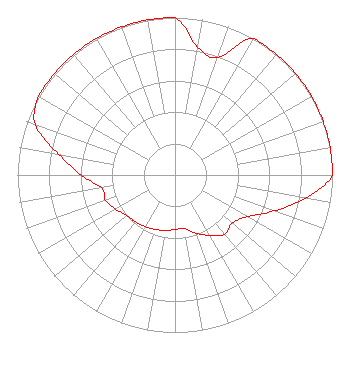 | ||||||||||||||||||
| Azimuth | Ratio | Azimuth | Ratio | Azimuth | Ratio | Azimuth | Ratio | ||||||||||||
| 0 | 1.000 | 10 | 0.825 | 20 | 0.794 | 30 | 1.000 | ||||||||||||
| 40 | 1.000 | 50 | 1.000 | 60 | 1.000 | 70 | 1.000 | ||||||||||||
| 80 | 1.000 | 90 | 1.000 | 100 | 0.841 | 110 | 0.668 | ||||||||||||
| 120 | 0.531 | 130 | 0.473 | 140 | 0.490 | 150 | 0.442 | ||||||||||||
| 160 | 0.394 | 170 | 0.346 | 180 | 0.346 | 190 | 0.357 | ||||||||||||
| 200 | 0.368 | 210 | 0.379 | 220 | 0.389 | 230 | 0.400 | ||||||||||||
| 240 | 0.435 | 250 | 0.469 | 260 | 0.473 | 270 | 0.596 | ||||||||||||
| 280 | 0.750 | 290 | 0.944 | 300 | 1.000 | 310 | 1.000 | ||||||||||||
| 320 | 1.000 | 330 | 1.000 | 340 | 1.000 | 350 | 1.000 | ||||||||||||
Structure Registration Number 1253985 Structure Type: GTOWER Registered To: WSJM, Inc. Structure Address: 0.5 Km North Of The Intersection Of 82nd Street & 46th Avenue, Van Buren County Covert Township, MI County Name: Van Buren County ASR Issued: 06/26/2014 Date Built: 12/21/2007 Site Elevation: 192 m (630 ft.) Structure Height: 132.9 m (436 ft.) Height Overall: 133.8 m (439 ft.) Overall Height AMSL: 325.8 m (1069 ft.) FAA Determination: 05/29/2014 FAA Study #: 2014-AGL-2359-OE FAA Circular #: 70/7460-1K Paint & Light FAA Chapters: 4, 6, 12 PRIOR STUDY 2008-AGL-4075-OE 42-15-13.9 N 86-20-09.7 W (NAD 83) 42-15-13.8 N 86-20-09.6 W (Converted to NAD 27) |
172 N Cedar St Imlay City, MI 48444 Phone: 888-887-7139 Not-for-Profit | Title: President Date: 10/01/2021 Application Certifier SMILE FM Smile Fm 172 N Cedar St Imlay City, MI 48444 Applicant EDWARD CZELADA Smile Fm 3302 N. Van Dyke Rd. Imlay City, MI 48444 PRESIDENT | |||||||||||||||||