
FCCInfo.com
A Service of Cavell, Mertz & Associates, Inc.
(855) FCC-INFO
|
|
|
|
|
||||||||||||||||
|
|
WWOU Channel: 213B 90.5 MHz Macomb, Illinois Service: FM - A full-service FM station or application. Facility ID: 763572 Fac. Service: FM Status: Construction Permit Application Accepted: 11/04/2021 Application Granted: 11/28/2022 File Number: -0000166177 WWOU CP Expires: 11/28/2025 Application Type: Non-Commercial Educational New NCE FM CP FCC Website Links: LMS Facility Details This Application Other WWOU Applications Other WWOU Applications in CDBS Including Superseded Applications Mailing Address Correspondence for WWOU Correspondence related to application -0000166177 Service Contour - Open Street Map or USGS Map (60 dBu) Service Contour - KML / Google Earth (60 dBu) Public Inspection Files Facility Type: NON-COMMERCIAL EDUC. FM Class: B, A Zone I or I-A station; with 25kW-50kW ERP and a class contour distance 39km-52km Site Location: 40-32-44.2 N 90-29-09.0 W (NAD 83) Site Location: 40-32-44.1 N 90-29-08.5 W (Converted to NAD 27) Effective Radiated Power: 30 kW Antenna Center HAAT: 61 m (200 ft.) Antenna Center AMSL: 255 m (837 ft.) Antenna Center HAG: 66 m (217 ft.) Site Elevation: 189.3 m. (621 ft.) Height Overall*: 122.8 m (403 ft.) (* As Filed In This Application, may differ from ASR Data, Below.) Directional Antenna Antenna Make/Model: None Antenna ID: 69-2019-08-06 Polarization: | ||||||||||||||||||
| Antenna Data for Antenna Id: 69-2019-08-06 WWOU FM File: -0000166177 None - Service: FM | 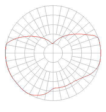 | ||||||||||||||||||
| Azimuth | Ratio | Azimuth | Ratio | Azimuth | Ratio | Azimuth | Ratio | ||||||||||||
| 0 | 0.200 | 10 | 0.245 | 20 | 0.309 | 30 | 0.389 | ||||||||||||
| 40 | 0.490 | 50 | 0.617 | 60 | 0.777 | 70 | 0.978 | ||||||||||||
| 80 | 0.999 | 90 | 1.000 | 100 | 1.000 | 110 | 0.969 | ||||||||||||
| 120 | 0.897 | 130 | 0.808 | 140 | 0.754 | 150 | 0.740 | ||||||||||||
| 160 | 0.742 | 170 | 0.738 | 180 | 0.751 | 190 | 0.866 | ||||||||||||
| 200 | 0.945 | 210 | 0.995 | 220 | 1.000 | 230 | 0.989 | ||||||||||||
| 240 | 0.998 | 250 | 1.000 | 260 | 1.000 | 270 | 1.000 | ||||||||||||
| 280 | 1.000 | 290 | 0.856 | 300 | 0.685 | 310 | 0.543 | ||||||||||||
| 320 | 0.431 | 330 | 0.342 | 340 | 0.272 | 350 | 0.216 | ||||||||||||
Structure Registration Number 1010573 Structure Type: GTOWER Registered To: American Towers LLC Structure Address: North 1850th Road (283074) Bushnell, IL County Name: McDonough County ASR Issued: 09/21/2017 Date Built: 07/29/1992 Site Elevation: 189.3 m (621 ft.) Structure Height: 121.9 m (400 ft.) Height Overall: 122.8 m (403 ft.) Overall Height AMSL: 312.1 m (1024 ft.) FAA Determination: 09/15/2017 FAA Study #: 2017-AGL-7185-OE FAA Circular #: 70/7460-1L Paint & Light FAA Chapters: 4, 8, 12 PRIOR STUDY 1996-AGL-4241-OE 40-32-44.2 N 90-29-09.0 W (NAD 83) 40-32-44.1 N 90-29-08.5 W (Converted to NAD 27) |
108 Boeykens Pl Normal, IL 61761 Phone: 309-242-4244 Not-for-Profit | Title: President Date: 11/04/2021 Application Certifier 2820 Communications Inc 108 Boeykens Pl Normal, IL 61761 Applicant jon hall 2820 Communications Inc 108 Boeykens Pl Normal, IL 61761 President | |||||||||||||||||