
FCCInfo.com
A Service of Cavell, Mertz & Associates, Inc.
(855) FCC-INFO
|
|
|
|
|
||||||||||||||||
|
|
K278AM Channel: 278D 103.5 MHz Spearfish, South Dakota Service: FX - A translator or application for a translator. Facility ID: 67365 Fac. Service: FX Programming Delivery Method: Unspecified Status: Construction Permit Application Accepted: 10/26/2021 Application Granted: 10/27/2021 File Number: -0000151039 K278AM CP Expires: 10/26/2024 Application Type: Minor Amendment FCC Website Links: LMS Facility Details This Application Other K278AM Applications Other K278AM Applications in CDBS Including Superseded Applications Mailing Address Correspondence for K278AM Correspondence related to application -0000151039 Service Contour - Open Street Map or USGS Map (60 dBu) Service Contour - KML / Google Earth (60 dBu) Facility Type: FM STATION Class: D, A Noncommercial educational operating with no more than 10W Site Location: 44-19-34.5 N 103-50-07.9 W (NAD 83) Site Location: 44-19-34.6 N 103-50-06.2 W (Converted to NAD 27) Effective Radiated Power: 0.25 kW Antenna Center HAAT: 292 m Horiz.; 0 m Vert. Antenna Center AMSL: 2179.6 m (7151 ft.) Antenna Center HAG: 60 m (197 ft.) Site Elevation: 2119.6 m. (6954 ft.) Height Overall*: 158.2 m (519 ft.) (* As Filed In This Application, may differ from ASR Data, Below.) Directional Antenna Antenna Make/Model: Bext TFCK2 Antenna ID: 0 Polarization: H
| ||||||||||||||||||
| Antenna Data for Antenna Id: 0 K278AM FX File: -0000151039 Bext - TFCK2 Service: FX | 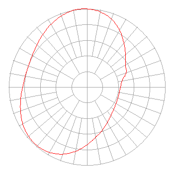 | ||||||||||||||||||
| Azimuth | Ratio | Azimuth | Ratio | Azimuth | Ratio | Azimuth | Ratio | ||||||||||||
| 0 | 0.998 | 10 | 0.974 | 20 | 0.920 | 30 | 0.834 | ||||||||||||
| 40 | 0.733 | 50 | 0.641 | 60 | 0.568 | 70 | 0.532 | ||||||||||||
| 80 | 0.455 | 90 | 0.429 | 100 | 0.418 | 110 | 0.419 | ||||||||||||
| 120 | 0.427 | 130 | 0.444 | 140 | 0.475 | 150 | 0.521 | ||||||||||||
| 160 | 0.584 | 170 | 0.651 | 180 | 0.739 | 190 | 0.833 | ||||||||||||
| 200 | 0.913 | 210 | 0.962 | 220 | 0.982 | 230 | 0.975 | ||||||||||||
| 240 | 0.946 | 250 | 0.903 | 260 | 0.859 | 270 | 0.822 | ||||||||||||
| 280 | 0.800 | 290 | 0.794 | 300 | 0.806 | 310 | 0.835 | ||||||||||||
| 320 | 0.876 | 330 | 0.923 | 340 | 0.965 | 350 | 0.993 | ||||||||||||
| 356 | 1.000 | 357 | 1.000 | 358 | 1.000 | ||||||||||||||
Structure Registration Number 1203805 Structure Type: GTOWER Registered To: Riverfront Broadcasting, LLC Structure Address: Terry Peak 3.3 Mo. Sw Lead, SD County Name: Lawrence County ASR Issued: 10/03/2019 Date Built: 05/01/2003 Site Elevation: 2119.6 m (6954 ft.) Structure Height: 158.2 m (519 ft.) Height Overall: 158.2 m (519 ft.) Overall Height AMSL: 2277.8 m (7473 ft.) FAA Determination: 04/11/2018 FAA Study #: 2018-AGL-5558-OE FAA Circular #: 70/7460-1L Paint & Light FAA Chapters: 3, 4, 5, 12 PRIOR STUDY 2013-AGL-10262-OE 44-19-34.5 N 103-50-07.9 W (NAD 83) 44-19-34.6 N 103-50-06.2 W (Converted to NAD 27) |
407 West 11th Street Yankton, SD 57078 Phone: 605-661-2393 Limited Liability Company | Title: Vice President Date: 10/26/2021 Application Certifier RIVERFRONT BROADCASTING, LLC Riverfront Broadcasting, Llc 3008 Mulligan Drive Yankton, SD 57078 Applicant David D. Oxenford Wilkinson, Barker, Knauer, Llp 1800 M Street, Nw Suite 800n Washington, DC 20036 Donald Lynch Horizon Broadcast Solutions, Llc 111 Sam Houston Dr. Kerrville, TX 78028 | |||||||||||||||||