
FCCInfo.com
A Service of Cavell, Mertz & Associates, Inc.
(855) FCC-INFO
|
|
|
|
|
||||||||||||||||
|
|
Channel: 217A 91.3 MHz Coalinga, California Service: FM - A full-service FM station or application. Facility ID: 766037 Fac. Service: FM Status: Construction Permit Application Accepted: 11/08/2021 Application Granted: 12/21/2021 File Number: -0000167154 CP Expires: 12/21/2024 Application Type: Non-Commercial Educational New NCE FM CP FCC Website Links: LMS Facility Details This Application Other Applications Other Applications in CDBS Including Superseded Applications Mailing Address Correspondence for Correspondence related to application -0000167154 Service Contour - Open Street Map or USGS Map (60 dBu) Service Contour - KML / Google Earth (60 dBu) Facility Type: NON-COMMERCIAL EDUC. FM Class: A, A Zone I; I-A; or II station; with 0.1kW-6kW ERP and a class contour distance <=28km Site Location: 36-18-14.9 N 120-24-09.5 W (NAD 83) Site Location: 36-18-15.1 N 120-24-05.9 W (Converted to NAD 27) Effective Radiated Power: 0.03 kW Antenna Center HAAT: 668.7 m (2194 ft.) Antenna Center AMSL: 1120.3 m (3676 ft.) Antenna Center HAG: 17 m (56 ft.) Site Elevation: 1103.3 m. (3620 ft.) Height Overall*: 60 m (197 ft.) (* As Filed In This Application, may differ from ASR Data, Below.) Directional Antenna Antenna Make/Model: None Antenna ID: 69-2019-08-06 Polarization: | ||||||||||||||||||
| Antenna Data for Antenna Id: 69-2019-08-06 FM File: -0000167154 None - Service: FM | 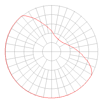 | ||||||||||||||||||
| Azimuth | Ratio | Azimuth | Ratio | Azimuth | Ratio | Azimuth | Ratio | ||||||||||||
| 0 | 0.445 | 10 | 0.357 | 20 | 0.319 | 30 | 0.300 | ||||||||||||
| 40 | 0.297 | 50 | 0.307 | 60 | 0.338 | 70 | 0.396 | ||||||||||||
| 80 | 0.478 | 90 | 0.587 | 100 | 0.721 | 110 | 0.885 | ||||||||||||
| 120 | 1.000 | 130 | 1.000 | 140 | 1.000 | 150 | 1.000 | ||||||||||||
| 160 | 1.000 | 170 | 1.000 | 180 | 1.000 | 190 | 1.000 | ||||||||||||
| 200 | 1.000 | 210 | 1.000 | 220 | 1.000 | 230 | 1.000 | ||||||||||||
| 240 | 1.000 | 250 | 1.000 | 260 | 1.000 | 270 | 1.000 | ||||||||||||
| 280 | 1.000 | 290 | 1.000 | 300 | 1.000 | 310 | 1.000 | ||||||||||||
| 320 | 1.000 | 330 | 0.848 | 340 | 0.674 | 350 | 0.542 | ||||||||||||
Structure Registration Number 1051059 Structure Type: TOWER Registered To: American Towers LLC Structure Address: Top Of Joaquin Ridge, Monterey Rd. (joaquin Ridge #8546) Coalinga, CA County Name: Fresno County ASR Issued: 01/15/2013 Date Built: 08/27/2001 Site Elevation: 1103.3 m (3620 ft.) Structure Height: 56.4 m (185 ft.) Height Overall: 60 m (197 ft.) Overall Height AMSL: 1163.3 m (3817 ft.) FAA Determination: 01/24/2005 FAA Study #: 2005-AWP-142-OE Paint & Light FAA Chapters: NONE PRIOR STUDY 2004-AWP-3028-OE 36-18-14.9 N 120-24-09.5 W (NAD 83) 36-18-15.1 N 120-24-05.9 W (Converted to NAD 27) |
1318 N Crescent Heights Blvd #210 West Hollywood, CA 90046 Phone: 310-488-8972 Not-for-Profit | Title: Director Date: 11/08/2021 Application Certifier Coalinga Public Broadcast Service 1318 N Crescent Heights Blvd #210 West Hollywood, CA 90046 Applicant Darrick Servis Community Radio Consultant 1623 5th St Ste. A Davis, CA 95616 Alanna Berkson Coalinga Public Broadcast Service 1318 N Crescent Heights Blvd #210 West Hollywood, CA 90046 | |||||||||||||||||