
FCCInfo.com
A Service of Cavell, Mertz & Associates, Inc.
(855) FCC-INFO
|
|
|
|
|
||||||||||||||||
|
|
WPHO Channel: 209B 89.7 MHz Burtchville, Michigan Service: FM - A full-service FM station or application. Facility ID: 768289 Fac. Service: FM Status: Construction Permit Application Accepted: 11/09/2021 Application Granted: 04/19/2022 File Number: -0000167791 WPHO CP Expires: 04/19/2025 Application Type: Non-Commercial Educational New NCE FM CP FCC Website Links: LMS Facility Details This Application Other WPHO Applications Other WPHO Applications in CDBS Including Superseded Applications Mailing Address Correspondence for WPHO Correspondence related to application -0000167791 Service Contour - Open Street Map or USGS Map (60 dBu) Service Contour - KML / Google Earth (60 dBu) Public Inspection Files Facility Type: NON-COMMERCIAL EDUC. FM Class: B, A Zone I or I-A station; with 25kW-50kW ERP and a class contour distance 39km-52km Site Location: 43-04-08.0 N 82-28-48.0 W (NAD 83) Site Location: 43-04-07.9 N 82-28-48.3 W (Converted to NAD 27) Effective Radiated Power: 31 kW Horiz. ; 0 kW Vert. Antenna Center HAAT: 27 m Horiz.; 0 m Vert. Antenna Center AMSL: 226 m Horiz.; 0 m Vert. Antenna Center HAG: 43 m Horiz.; 0 m Vert. Site Elevation: 183 m. (600 ft.) Height Overall*: 119 m (390 ft.) (* As Filed In This Application, may differ from ASR Data, Below.) Directional Antenna Antenna Make/Model: None Antenna ID: 69-2019-08-06 Polarization:
| ||||||||||||||||||
| Antenna Data for Antenna Id: 69-2019-08-06 WPHO FM File: -0000167791 None - Service: FM | 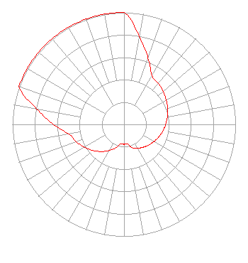 | ||||||||||||||||||
| Azimuth | Ratio | Azimuth | Ratio | Azimuth | Ratio | Azimuth | Ratio | ||||||||||||
| 0 | 1.000 | 10 | 0.794 | 20 | 0.631 | 30 | 0.501 | ||||||||||||
| 40 | 0.480 | 50 | 0.459 | 60 | 0.437 | 70 | 0.416 | ||||||||||||
| 80 | 0.395 | 90 | 0.373 | 100 | 0.352 | 110 | 0.331 | ||||||||||||
| 120 | 0.309 | 130 | 0.288 | 140 | 0.267 | 150 | 0.245 | ||||||||||||
| 160 | 0.224 | 170 | 0.178 | 180 | 0.178 | 190 | 0.178 | ||||||||||||
| 200 | 0.224 | 210 | 0.270 | 220 | 0.316 | 230 | 0.363 | ||||||||||||
| 240 | 0.409 | 250 | 0.455 | 260 | 0.501 | 270 | 0.631 | ||||||||||||
| 280 | 0.794 | 290 | 1.000 | 300 | 1.000 | 310 | 1.000 | ||||||||||||
| 320 | 1.000 | 330 | 1.000 | 340 | 1.000 | 350 | 1.000 | ||||||||||||
Structure Registration Number 1005777 Structure Type: TOWER Registered To: PORT HURON FAMILY RADIO INC DBA = WGRT FM Structure Address: 3530 Brace Rd Fort Gratiot, MI County Name: St. Clair County ASR Issued: 12/30/1996 Date Built: 01/01/1991 Site Elevation: 182.9 m (600 ft.) Structure Height: 4.5 m (15 ft.) Height Overall: 118.6 m (389 ft.) Overall Height AMSL: 301.4 m (989 ft.) FAA Determination: 05/05/1983 FAA Study #: 83-AGL-716-OE Paint & Light FAA Chapters: 1, 3, 12, 21 43-04-08.0 N 82-28-48.0 W (NAD 83) 43-04-07.9 N 82-28-48.3 W (Converted to NAD 27) |
172 N Cedar St Imlay City, MI 48444 Phone: 810-895-2040 Not-for-Profit | Title: President Date: 11/09/2021 Application Certifier Smile Fm 172 N Cedar St Imlay City, MI 48444 Applicant Smile Fm 172 N Cedar St Imlay City, 48444 Applicant Ed Czelada Smile Fm 3302 N. Van Dyke Road Imlay City, MI 48444 | |||||||||||||||||