
FCCInfo.com
A Service of Cavell, Mertz & Associates, Inc.
(855) FCC-INFO
|
|
WQKI-FM from 12/08/1987 |
|
|
|||||||||||||||||||
|
|
WQKI-FM Channel: 239A 95.7 MHz Orangeburg, South Carolina Service: FM - A full-service FM station or application. Facility ID: 6484 Fac. Service: FM Status: License 73.215 Station Application Accepted: 11/16/2021 Application Granted: 12/09/2021 File Number: -0000168939 License Expires: 12/01/2027 Application Type: License To Cover FCC Website Links: LMS Facility Details This Application Other WQKI-FM Applications Other WQKI-FM Applications in CDBS Including Superseded Applications Mailing Address Correspondence for WQKI-FM Correspondence related to application -0000168939 Service Contour - Open Street Map or USGS Map (60 dBu) Service Contour - KML / Google Earth (60 dBu) Public Inspection Files Facility Type: FM STATION Class: A, A Zone I; I-A; or II station; with 0.1kW-6kW ERP and a class contour distance <=28km Site Location: 33-26-35.6 N 80-48-15.3 W (NAD 83) Site Location: 33-26-35.0 N 80-48-16.0 W (Converted to NAD 27) Effective Radiated Power: 4 kW Antenna Center HAAT: 123.3 m (405 ft.) Antenna Center AMSL: 178.4 m (585 ft.) Antenna Center HAG: 123.5 m (405 ft.) Calculated Site Elevation: 54.9 m. (180 ft.) Height Overall*: 152.4 m (500 ft.) (* As Filed In This Application, may differ from ASR Data, Below.) Directional Antenna Antenna Make/Model: Dielectric DCRT4R Antenna ID: 133869 Polarization:
| |||||||||||||||||||||
| Antenna Data for Antenna Id: 133869 WQKI-FM FM File: -0000168939 Dielectric - DCRT4R Service: FM | 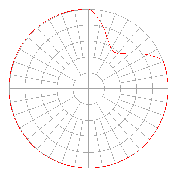 | |||||||||||||||||||||
| Azimuth | Ratio | Azimuth | Ratio | Azimuth | Ratio | Azimuth | Ratio | |||||||||||||||
| 0 | 1.000 | 10 | 0.851 | 20 | 0.680 | 30 | 0.572 | |||||||||||||||
| 40 | 0.572 | 45 | 0.626 | 50 | 0.680 | 60 | 0.851 | |||||||||||||||
| 70 | 1.000 | 80 | 1.000 | 90 | 1.000 | 100 | 1.000 | |||||||||||||||
| 110 | 1.000 | 120 | 1.000 | 130 | 1.000 | 135 | 1.000 | |||||||||||||||
| 140 | 1.000 | 150 | 1.000 | 160 | 1.000 | 170 | 1.000 | |||||||||||||||
| 180 | 1.000 | 190 | 1.000 | 200 | 1.000 | 210 | 1.000 | |||||||||||||||
| 220 | 1.000 | 225 | 1.000 | 230 | 1.000 | 240 | 1.000 | |||||||||||||||
| 250 | 1.000 | 260 | 1.000 | 270 | 1.000 | 280 | 1.000 | |||||||||||||||
| 290 | 1.000 | 300 | 1.000 | 310 | 1.000 | 315 | 1.000 | |||||||||||||||
| 320 | 1.000 | 330 | 1.000 | 340 | 1.000 | 350 | 1.000 | |||||||||||||||
Structure Registration Number 1242373 Structure Type: TOWER Registered To: Miller Communications, Inc. Structure Address: Off Hwy 178 At Weatherford Road Orangeburg, SC County Name: Orangeburg County ASR Issued: 05/06/2011 Date Built: 05/05/2006 Site Elevation: 54.9 m (180 ft.) Structure Height: 151.9 m (498 ft.) Height Overall: 152.4 m (500 ft.) Overall Height AMSL: 207.3 m (680 ft.) FAA Determination: 08/17/2006 FAA Study #: 2006-ASO-4309-OE Paint & Light FAA Chapters: 3, 4, 13, 21 PRIOR STUDY 2003-ASO-6438-OE 33-26-36.0 N 80-48-15.8 W (NAD 83) 33-26-35.4 N 80-48-16.5 W (Converted to NAD 27) |
199 Wealtha Avenue Watertown, NY 13601 Phone: 315-782-1240 Limited Liability Company | Title: President Date: 11/16/2021 Application Certifier COMMUNITY BROADCASTERS, LLC Community Broadcasters, Llc 199 Wealtha Avenue Watertown, NY 13601 Applicant Carl E Gluck Carl T Jones Corp Carl T Jones Corp 7901 Yarnwood Court Springfield, VA 22153 Technical Consultant FRANCISCO R. MONTERO, ESQ Fletcher, Heald & Hildreth, P.l.c. 1300 North 17th Street 11th Floor Arlington, VA 22209 | ||||||||||||||||||||
|
| |||||||||||||||||||||