
FCCInfo.com
A Service of Cavell, Mertz & Associates, Inc.
(855) FCC-INFO
|
|
WEQR from 12/10/2021 |
|
|
||||||||||||||||
|
|
WEQR Channel: 265C3 100.9 MHz Tomahawk, Wisconsin Service: FM - A full-service FM station or application. Facility ID: 762363 Fac. Service: FM Status: Construction Permit 73.215 Station Application Accepted: 12/02/2021 Application Granted: 12/10/2021 File Number: -0000159077 WEQR CP Expires: 12/10/2024 Application Type: Amendment FCC Website Links: LMS Facility Details This Application Other WEQR Applications Other WEQR Applications in CDBS Including Superseded Applications Mailing Address Correspondence for WEQR Correspondence related to application -0000159077 Service Contour - Open Street Map or USGS Map (60 dBu) Service Contour - KML / Google Earth (60 dBu) Public Inspection Files Facility Type: FM STATION Class: C3, A Zone II station; with 6kW-25kW ERP and a class contour distance 28km-39km Site Location: 45-21-07.6 N 89-39-13.0 W (NAD 83) Site Location: 45-21-07.7 N 89-39-12.5 W (Converted to NAD 27) Effective Radiated Power: 8.5 kW Antenna Center HAAT: 173 m (568 ft.) Antenna Center AMSL: 626 m (2054 ft.) Antenna Center HAG: 94 m (308 ft.) Site Elevation: 532.2 m. (1746 ft.) Height Overall*: 127.7 m (419 ft.) (* As Filed In This Application, may differ from ASR Data, Below.) Directional Antenna Antenna Make/Model: None Antenna ID: 69-2019-08-06 Polarization: | ||||||||||||||||||
| Antenna Data for Antenna Id: 69-2019-08-06 WEQR FM File: -0000159077 None - Service: FM | 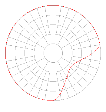 | ||||||||||||||||||
| Azimuth | Ratio | Azimuth | Ratio | Azimuth | Ratio | Azimuth | Ratio | ||||||||||||
| 0 | 1.000 | 10 | 1.000 | 20 | 1.000 | 30 | 1.000 | ||||||||||||
| 40 | 1.000 | 50 | 1.000 | 60 | 1.000 | 70 | 1.000 | ||||||||||||
| 80 | 1.000 | 90 | 0.828 | 100 | 0.658 | 110 | 0.545 | ||||||||||||
| 120 | 0.488 | 130 | 0.477 | 140 | 0.511 | 150 | 0.590 | ||||||||||||
| 160 | 0.692 | 170 | 0.871 | 180 | 1.000 | 190 | 1.000 | ||||||||||||
| 200 | 1.000 | 210 | 1.000 | 220 | 1.000 | 230 | 1.000 | ||||||||||||
| 240 | 1.000 | 250 | 1.000 | 260 | 1.000 | 270 | 1.000 | ||||||||||||
| 280 | 1.000 | 290 | 1.000 | 300 | 1.000 | 310 | 1.000 | ||||||||||||
| 320 | 1.000 | 330 | 1.000 | 340 | 1.000 | 350 | 1.000 | ||||||||||||
Structure Registration Number 1277357 Structure Type: GTOWER Registered To: WRVM, Inc. Structure Address: N6488 Irma Towers Road Irma, WI County Name: Lincoln County ASR Issued: 06/11/2019 Date Built: 06/13/2019 Site Elevation: 532.2 m (1746 ft.) Structure Height: 122.8 m (403 ft.) Height Overall: 127.7 m (419 ft.) Overall Height AMSL: 659.9 m (2165 ft.) FAA Determination: 05/16/2019 FAA Study #: 2019-AGL-8224-OE FAA Circular #: 70/7460-1L Paint & Light FAA Chapters: 4, 8, 12 PRIOR STUDY 2010-AGL-5404-OE 45-21-07.6 N 89-39-13.0 W (NAD 83) 45-21-07.7 N 89-39-12.5 W (Converted to NAD 27) |
1314 Stannard Drive Sparta, WI 54656 Phone: 608-633-8265 Corporation | Title: Vice President Date: 12/02/2021 Application Certifier The Salvation Poem Foundation, Inc. 1314 Stannard Drive Sparta, WI 54656 Applicant Robert Moore Rcm Engineering 1908 Sweetbriar Goshen, IN 46528 Consultant Matthew H McCormick Fletcher, Heald & Hildreth, Plc 1300 N. 17th Street Suite 1100 Arlington, VA 22209 Member | |||||||||||||||||