
FCCInfo.com
A Service of Cavell, Mertz & Associates, Inc.
(855) FCC-INFO
|
|
|
|
|
||||||||||||||||
|
|
Channel: 211B 90.1 MHz Allen Park, Michigan Service: FM - A full-service FM station or application. Facility ID: 768011 Fac. Service: FM Status: Construction Permit Application Accepted: 01/07/2022 Application Granted: 02/29/2024 File Number: -0000167787 CP Expires: 02/28/2027 Application Type: Non-Commercial Educational Amendment FCC Website Links: LMS Facility Details This Application Other Applications Other Applications in CDBS Including Superseded Applications Mailing Address Correspondence for Correspondence related to application -0000167787 Service Contour - Open Street Map or USGS Map (60 dBu) Service Contour - KML / Google Earth (60 dBu) Facility Type: NON-COMMERCIAL EDUC. FM Class: B, A Zone I or I-A station; with 25kW-50kW ERP and a class contour distance 39km-52km Site Location: 42-10-08.0 N 83-12-49.0 W (NAD 83) Site Location: 42-10-07.9 N 83-12-49.3 W (Converted to NAD 27) Effective Radiated Power: 50 kW Antenna Center HAAT: 95 m (312 ft.) Antenna Center AMSL: 271 m (889 ft.) Antenna Center HAG: 89 m (292 ft.) Site Elevation: 181.7 m. (596 ft.) Height Overall*: 96.3 m (316 ft.) (* As Filed In This Application, may differ from ASR Data, Below.) Directional Antenna Antenna Make/Model: None Antenna ID: 0 Polarization: H | ||||||||||||||||||
| Antenna Data for Antenna Id: 0 FM File: -0000167787 None - Service: FM | 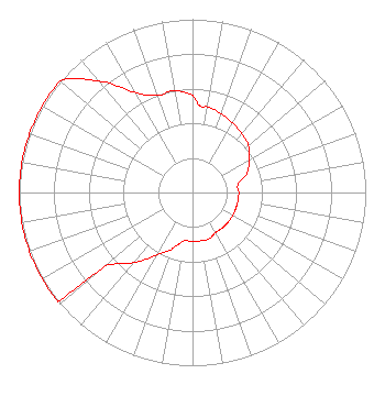 | ||||||||||||||||||
| Azimuth | Ratio | Azimuth | Ratio | Azimuth | Ratio | Azimuth | Ratio | ||||||||||||
| 0 | 0.562 | 5 | 0.501 | 10 | 0.501 | 20 | 0.483 | ||||||||||||
| 30 | 0.462 | 40 | 0.443 | 50 | 0.422 | 60 | 0.377 | ||||||||||||
| 70 | 0.336 | 80 | 0.267 | 90 | 0.267 | 100 | 0.267 | ||||||||||||
| 110 | 0.267 | 120 | 0.267 | 130 | 0.267 | 140 | 0.267 | ||||||||||||
| 150 | 0.267 | 160 | 0.283 | 170 | 0.283 | 180 | 0.283 | ||||||||||||
| 190 | 0.283 | 195 | 0.310 | 200 | 0.348 | 210 | 0.420 | ||||||||||||
| 220 | 0.529 | 230 | 0.660 | 231 | 1.000 | 240 | 1.000 | ||||||||||||
| 250 | 1.000 | 260 | 1.000 | 270 | 1.000 | 280 | 1.000 | ||||||||||||
| 290 | 1.000 | 300 | 1.000 | 310 | 1.000 | 320 | 0.841 | ||||||||||||
| 330 | 0.668 | 340 | 0.596 | 350 | 0.596 | ||||||||||||||
Structure Registration Number 1006095 Structure Type: TOWER Registered To: VB Nimbus, LLC Structure Address: Sw Cor Sibley Rd & Grange Rd Riverview, MI County Name: Wayne County ASR Issued: 10/15/2020 Date Built: 01/01/1985 Site Elevation: 181.7 m (596 ft.) Structure Height: 95.4 m (313 ft.) Height Overall: 96.3 m (316 ft.) Overall Height AMSL: 278 m (912 ft.) FAA Determination: 10/11/1996 FAA Study #: 96-AGL-3232-OE FAA Circular #: 70/7460-1J Paint & Light FAA Chapters: 3, 4, 5, 13 42-10-08.0 N 83-12-49.0 W (NAD 83) 42-10-07.9 N 83-12-49.3 W (Converted to NAD 27) |
172 N Cedar St Imlay City, MI 48444 Phone: 181-089-5204 Not-for-Profit | Title: President Date: 01/07/2022 Application Certifier Smile Fm 172 N Cedar St Imlay City, MI 48444 Applicant Edward Czelada Smile Fm 172 N Cedar St Imlay City, MI 48444 | |||||||||||||||||