
FCCInfo.com
A Service of Cavell, Mertz & Associates, Inc.
(855) FCC-INFO
|
|
|
|
|
||||||||||||||||
|
|
W256DQ Channel: 256D 99.1 MHz Cleveland, Tennessee Service: FX - A translator or application for a translator. Facility ID: 202461 Fac. Service: FX Programming Delivery Method: Unspecified Status: License Application Accepted: 06/29/2022 Application Granted: 07/12/2022 File Number: -0000194165 License Expires: 08/01/2028 Application Type: License To Cover FCC Website Links: LMS Facility Details This Application Other W256DQ Applications Other W256DQ Applications in CDBS Including Superseded Applications Mailing Address Correspondence for W256DQ Correspondence related to application -0000194165 Service Contour - Open Street Map or USGS Map (60 dBu) Service Contour - KML / Google Earth (60 dBu) Facility Type: FM STATION Class: D, A Noncommercial educational operating with no more than 10W Site Location: 35-10-54.3 N 84-50-54.8 W (NAD 83) Site Location: 35-10-54.0 N 84-50-55.0 W (Converted to NAD 27) Effective Radiated Power: 0.25 kW Antenna Center HAAT: 0 m Antenna Center AMSL: 363 m (1191 ft.) Antenna Center HAG: 84 m (276 ft.) Site Elevation: 279 m. (915 ft.) Height Overall*: 92 m (302 ft.) (* As Filed In This Application, may differ from ASR Data, Below.) Directional Antenna Antenna Make/Model: Nicom NIC BKG77-2 Antenna ID: 135443 Polarization:
| ||||||||||||||||||
| Antenna Data for Antenna Id: 135443 W256DQ FX File: -0000194165 Nicom - NIC BKG77-2 Service: FX | 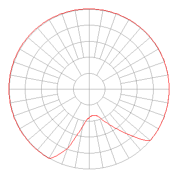 | ||||||||||||||||||
| Azimuth | Ratio | Azimuth | Ratio | Azimuth | Ratio | Azimuth | Ratio | ||||||||||||
| 0 | 1.000 | 10 | 1.000 | 20 | 1.000 | 30 | 1.000 | ||||||||||||
| 40 | 1.000 | 50 | 1.000 | 60 | 1.000 | 70 | 1.000 | ||||||||||||
| 80 | 1.000 | 90 | 1.000 | 100 | 1.000 | 110 | 1.000 | ||||||||||||
| 120 | 1.000 | 130 | 1.000 | 140 | 0.729 | 150 | 0.520 | ||||||||||||
| 155 | 0.445 | 160 | 0.376 | 165 | 0.346 | 170 | 0.341 | ||||||||||||
| 175 | 0.339 | 180 | 0.362 | 185 | 0.397 | 190 | 0.489 | ||||||||||||
| 195 | 0.615 | 200 | 0.795 | 210 | 1.000 | 220 | 1.000 | ||||||||||||
| 230 | 1.000 | 240 | 1.000 | 250 | 1.000 | 260 | 1.000 | ||||||||||||
| 270 | 1.000 | 280 | 1.000 | 290 | 1.000 | 300 | 1.000 | ||||||||||||
| 310 | 1.000 | 320 | 1.000 | 330 | 1.000 | 340 | 1.000 | ||||||||||||
| 350 | 1.000 | ||||||||||||||||||
Structure Registration Number 1223889 Structure Type: TOWER Registered To: Hartline, LLC Structure Address: 1408 Weeks Dr Cleveland, TN County Name: Bradley County ASR Issued: 10/18/2016 Date Built: 01/01/1966 Site Elevation: 278.6 m (914 ft.) Structure Height: 91.4 m (300 ft.) Height Overall: 92.1 m (302 ft.) Overall Height AMSL: 370.7 m (1216 ft.) FAA Determination: 03/05/2001 FAA Study #: 01-ASO-0449-OE Paint & Light FAA Chapters: 1, 3, 12, 21 PRIOR STUDY 72-SO-314-OE PAINT/RED LIGHTS 35-10-54.1 N 84-50-54.4 W (NAD 83) 35-10-53.8 N 84-50-54.6 W (Converted to NAD 27) |
P.o. Box 2695 308 Mouse Creek Road Nw Cleveland, TN 37312 Phone: 423-472-6700 Limited Liability Company | Title: Managing Member Date: 06/29/2022 Application Certifier HARTLINE, LLC Hartline, Llc P.o. Box 2695 308 Mouse Creek Road Nw Cleveland, TN 37312 Applicant George C Hudson, III Hudson Management Group 4782 Waverly Court Ooltewah, TN 37363 Technical Director Mark Denbo Smithwick & Belendiuk, P.c. 5028 Wisconsin Avenue, N.w. Suite 301 Washington, DC 20016 Counsel | |||||||||||||||||