
FCCInfo.com
A Service of Cavell, Mertz & Associates, Inc.
(855) FCC-INFO
|
|
W283DQ from 01/28/2022 W283DQ from 03/09/2022 W283DQ from 08/16/2007 W283DQ from 11/01/2004 |
|
|
||||||||||||||||
|
|
W283DQ Channel: 283D 104.5 MHz Auburn, Alabama Service: FX - A translator or application for a translator. Facility ID: 152415 Fac. Service: FX Programming Delivery Method: Unspecified Status: License Application Accepted: 01/28/2022 Application Granted: 03/09/2022 File Number: -0000182456 License Expires: 04/01/2028 Application Type: License To Cover FCC Website Links: LMS Facility Details This Application Other W283DQ Applications Other W283DQ Applications in CDBS Including Superseded Applications Mailing Address Correspondence for W283DQ Correspondence related to application -0000182456 Service Contour - Open Street Map or USGS Map (60 dBu) Service Contour - KML / Google Earth (60 dBu) Facility Type: FM STATION Class: D, A Noncommercial educational operating with no more than 10W Site Location: 32-40-04.0 N 85-33-00.8 W (NAD 83) Site Location: 32-40-03.5 N 85-33-01.0 W (Converted to NAD 27) Effective Radiated Power: 0.25 kW Transmitter Output Power: 0.122 kW Antenna Center HAAT: 0 m Antenna Center AMSL: 345.1 m (1132 ft.) Antenna Center HAG: 122 m (400 ft.) Site Elevation: 223.1 m. (732 ft.) Height Overall*: 152.1 m (499 ft.) (* As Filed In This Application, may differ from ASR Data, Below.) Directional Antenna Antenna Make/Model: BEXT TFC2K-1 Antenna ID: 133346 Polarization: H
| ||||||||||||||||||
| Antenna Data for Antenna Id: 133346 W283DQ FX File: -0000182456 BEXT - TFC2K-1 Service: FX | 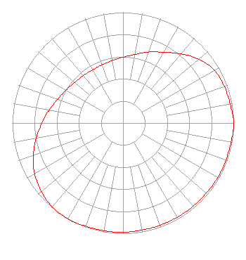 | ||||||||||||||||||
| Azimuth | Ratio | Azimuth | Ratio | Azimuth | Ratio | Azimuth | Ratio | ||||||||||||
| 0 | 0.594 | 10 | 0.628 | 20 | 0.682 | 30 | 0.738 | ||||||||||||
| 40 | 0.815 | 50 | 0.897 | 60 | 0.953 | 70 | 0.973 | ||||||||||||
| 80 | 0.983 | 90 | 1.000 | 100 | 0.992 | 110 | 0.988 | ||||||||||||
| 120 | 0.988 | 130 | 0.983 | 140 | 0.983 | 150 | 0.983 | ||||||||||||
| 160 | 0.983 | 170 | 0.983 | 180 | 0.988 | 190 | 0.988 | ||||||||||||
| 200 | 0.992 | 210 | 1.000 | 220 | 0.991 | 230 | 0.963 | ||||||||||||
| 240 | 0.923 | 250 | 0.862 | 260 | 0.797 | 270 | 0.731 | ||||||||||||
| 280 | 0.676 | 290 | 0.628 | 300 | 0.594 | 310 | 0.571 | ||||||||||||
| 320 | 0.558 | 330 | 0.553 | 340 | 0.558 | 350 | 0.571 | ||||||||||||
Structure Registration Number 1307550 Structure Type: GTOWER Registered To: Hubbard Properties LLC Structure Address: Farmville Road Auburn, AL County Name: Lee County ASR Issued: 11/06/2019 Date Built: 11/04/2019 Site Elevation: 223.1 m (732 ft.) Structure Height: 151 m (495 ft.) Height Overall: 152.1 m (499 ft.) Overall Height AMSL: 375.2 m (1231 ft.) FAA Determination: 07/17/2017 FAA Study #: 2017-ASO-12172-OE FAA Circular #: 70/7460-1L Paint & Light FAA Chapters: 3, 4, 5, 12 Removed expiration date from determination. Scenario 1./jjs/case#635066 32-40-04.0 N 85-33-00.8 W (NAD 83) 32-40-03.5 N 85-33-01.0 W (Converted to NAD 27) |
P.o. Box 629 Sylacauga, AL 35150 Phone: 202-384-9551 Corporation | Title: President Date: 01/28/2022 Application Certifier HUGHEY COMMUNICATIONS, INC. Hughey Communications, Inc. 320 Barnett Blvd. Tallassee, AL 36078 Applicant CHARLES M. ANDERSON Anderson Associates 5900 Lake Cyrus Drive Hoover, AL 35244 BROADCAST ENGINEERING CONSULTANT M. SCOTT JOHNSON, ESQ Smithwick & Belendiuk, Pc 5028 Wisconsin Avenue Nw Suite 301 Washington, DC 20016 LEGAL COUNSEL | |||||||||||||||||