
FCCInfo.com
A Service of Cavell, Mertz & Associates, Inc.
(855) FCC-INFO
|
|
|
|
|
||||||||||||||||
|
|
KSCF Channel: 204C1 88.7 MHz Scottsbluff, Nebraska Service: FM - A full-service FM station or application. Facility ID: 763260 Fac. Service: FM Status: Construction Permit Application Accepted: 02/01/2022 Application Granted: 03/07/2022 File Number: -0000166024 KSCF CP Expires: 03/07/2025 Application Type: Non-Commercial Educational Amendment FCC Website Links: LMS Facility Details This Application Other KSCF Applications Other KSCF Applications in CDBS Including Superseded Applications Mailing Address Correspondence for KSCF Correspondence related to application -0000166024 Service Contour - Open Street Map or USGS Map (60 dBu) Service Contour - KML / Google Earth (60 dBu) Public Inspection Files Facility Type: NON-COMMERCIAL EDUC. FM Class: C1, A Zone II station; with 50kW-100kW ERP and a class contour distance 52km-72km Site Location: 41-45-40.0 N 103-19-14.0 W (NAD 83) Site Location: 41-45-40.1 N 103-19-12.2 W (Converted to NAD 27) Effective Radiated Power: 60 kW Antenna Center HAAT: 38 m (125 ft.) Antenna Center AMSL: 1221 m (4006 ft.) Antenna Center HAG: 53 m (174 ft.) Site Elevation: 1168 m. (3832 ft.) Height Overall*: 61 m (200 ft.) (* As Filed In This Application, may differ from ASR Data, Below.) Directional Antenna Antenna Make/Model: None Antenna ID: 69-2019-08-06 Polarization: | ||||||||||||||||||
| Antenna Data for Antenna Id: 69-2019-08-06 KSCF FM File: -0000166024 None - Service: FM | 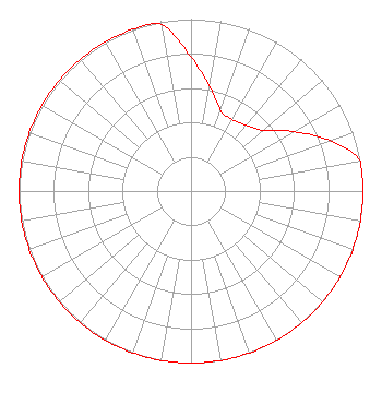 | ||||||||||||||||||
| Azimuth | Ratio | Azimuth | Ratio | Azimuth | Ratio | Azimuth | Ratio | ||||||||||||
| 0 | 0.780 | 10 | 0.620 | 20 | 0.500 | 30 | 0.480 | ||||||||||||
| 40 | 0.500 | 50 | 0.550 | 60 | 0.690 | 70 | 0.860 | ||||||||||||
| 80 | 1.000 | 90 | 1.000 | 100 | 1.000 | 110 | 1.000 | ||||||||||||
| 120 | 1.000 | 130 | 1.000 | 140 | 1.000 | 150 | 1.000 | ||||||||||||
| 160 | 1.000 | 170 | 1.000 | 180 | 1.000 | 190 | 1.000 | ||||||||||||
| 200 | 1.000 | 210 | 1.000 | 220 | 1.000 | 230 | 1.000 | ||||||||||||
| 240 | 1.000 | 250 | 1.000 | 260 | 1.000 | 270 | 1.000 | ||||||||||||
| 280 | 1.000 | 290 | 1.000 | 300 | 1.000 | 310 | 1.000 | ||||||||||||
| 320 | 1.000 | 330 | 1.000 | 340 | 1.000 | 350 | 0.980 | ||||||||||||
Structure Registration Number 1243780 Structure Type: TOWER Registered To: Industrial Communications & Electronics, Inc. Structure Address: Off 12th Street Bayard, NE County Name: Morrill County ASR Issued: 06/09/2004 Date Built: 06/28/2004 Site Elevation: 1168.3 m (3833 ft.) Structure Height: 59.4 m (195 ft.) Height Overall: 60.9 m (200 ft.) Overall Height AMSL: 1229.2 m (4033 ft.) FAA Determination: 03/29/2004 FAA Study #: 2004-ACE-453-OE Paint & Light FAA Chapters: NONE 41-45-39.6 N 103-19-13.5 W (NAD 83) 41-45-39.7 N 103-19-11.7 W (Converted to NAD 27) |
Po Box 30345 Lincoln, NE 68503 Phone: 402-770-4616 Not-for-Profit | Title: Officer Date: 02/01/2022 Application Certifier Mybridge, Dba As Mybridge Radio Po Box 30345 Lincoln, NE 68503 Applicant James E Price, III Sterling Communications, Inc. Po Box 1877 Lafayette, GA 30728 Legal Representative Charles Burkhart Sterling Communcations, Inc. Po Box 1877 Lafayette, GA 30728 Chief Engineer | |||||||||||||||||