
FCCInfo.com
A Service of Cavell, Mertz & Associates, Inc.
(855) FCC-INFO
|
|
|
|
|
||||||||||||||||
|
|
Channel: 201C3 88.1 MHz Rochester, Minnesota Service: FM - A full-service FM station or application. Facility ID: 767527 Fac. Service: FM Status: Construction Permit Application Accepted: 04/25/2022 Application Granted: 05/27/2022 File Number: -0000167674 CP Expires: 05/27/2025 Application Type: Non-Commercial Educational Amendment FCC Website Links: LMS Facility Details This Application Other Applications Other Applications in CDBS Including Superseded Applications Mailing Address Correspondence for Correspondence related to application -0000167674 Service Contour - Open Street Map or USGS Map (60 dBu) Service Contour - KML / Google Earth (60 dBu) Facility Type: NON-COMMERCIAL EDUC. FM Class: C3, A Zone II station; with 6kW-25kW ERP and a class contour distance 28km-39km Site Location: 44-00-24.2 N 92-43-07.0 W (NAD 83) Site Location: 44-00-24.3 N 92-43-06.3 W (Converted to NAD 27) Effective Radiated Power: 20.5 kW Antenna Center HAAT: 102 m (335 ft.) Antenna Center AMSL: 473 m (1552 ft.) Antenna Center HAG: 75 m (246 ft.) Site Elevation: 398.1 m. (1306 ft.) Height Overall*: 93.3 m (306 ft.) (* As Filed In This Application, may differ from ASR Data, Below.) Directional Antenna Antenna Make/Model: None Antenna ID: 69-2019-08-06 Polarization: | ||||||||||||||||||
| Antenna Data for Antenna Id: 69-2019-08-06 FM File: -0000167674 None - Service: FM | 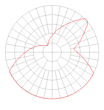 | ||||||||||||||||||
| Azimuth | Ratio | Azimuth | Ratio | Azimuth | Ratio | Azimuth | Ratio | ||||||||||||
| 0 | 0.355 | 10 | 0.447 | 20 | 0.563 | 30 | 0.709 | ||||||||||||
| 40 | 0.892 | 45 | 1.000 | 49 | 1.000 | 50 | 0.986 | ||||||||||||
| 60 | 0.783 | 70 | 0.622 | 80 | 0.494 | 82 | 0.474 | ||||||||||||
| 90 | 0.530 | 100 | 0.667 | 110 | 0.840 | 118 | 1.000 | ||||||||||||
| 120 | 1.000 | 130 | 1.000 | 140 | 1.000 | 150 | 1.000 | ||||||||||||
| 160 | 1.000 | 170 | 1.000 | 180 | 1.000 | 190 | 1.000 | ||||||||||||
| 200 | 1.000 | 210 | 1.000 | 220 | 1.000 | 230 | 1.000 | ||||||||||||
| 240 | 1.000 | 245 | 1.000 | 250 | 0.892 | 260 | 0.709 | ||||||||||||
| 270 | 0.563 | 280 | 0.447 | 290 | 0.355 | 300 | 0.282 | ||||||||||||
| 310 | 0.224 | 320 | 0.178 | 330 | 0.178 | 340 | 0.224 | ||||||||||||
| 350 | 0.282 | ||||||||||||||||||
Structure Registration Number 1210413 Structure Type: TOWER Registered To: CCATT LLC Structure Address: 25985 650th Street Kasson, MN County Name: Dodge County ASR Issued: 05/09/2016 Date Built: 06/26/2006 Site Elevation: 398.1 m (1306 ft.) Structure Height: 91.4 m (300 ft.) Height Overall: 93.3 m (306 ft.) Overall Height AMSL: 491.4 m (1612 ft.) FAA Determination: 07/27/2010 FAA Study #: 2010-AGL-3007-OE FAA Circular #: 70/7460-1J Paint & Light FAA Chapters: 4, 8, 13 PRIOR STUDY 2006-AGL-5671-OE 44-00-24.2 N 92-43-07.0 W (NAD 83) 44-00-24.3 N 92-43-06.3 W (Converted to NAD 27) |
65742 Highway 56 Dodge Center, MN 55927 Phone: 507-374-6761 Not-for-Profit | Title: President Date: 04/25/2022 Application Certifier One Day Church Project, Inc. 65742 Highway 56 Dodge Center, MN 55927 Applicant Luke Rogers Luke Rogers Consulting 1435 Woodland Ridge Rd Odenville, AL 35120 DONALD MARTIN Law Office Of Donald E Martin P.o. Box 8433 Falls Church, VA 22041 Attorney | |||||||||||||||||