
FCCInfo.com
A Service of Cavell, Mertz & Associates, Inc.
(855) FCC-INFO
|
|
W244EN from 01/14/2016 W244EN from 04/24/2013 |
|
|
||||||||||||||||
|
|
W244EN Channel: 244D 96.7 MHz Lapeer, Michigan Service: FX - A translator or application for a translator. Facility ID: 157076 Fac. Service: FX Programming Delivery Method: Unspecified Status: License Application Accepted: 05/24/2022 Application Granted: 06/03/2022 File Number: -0000191482 License Expires: 10/01/2028 Application Type: License To Cover FCC Website Links: LMS Facility Details This Application Other W244EN Applications Other W244EN Applications in CDBS Including Superseded Applications Mailing Address Correspondence for W244EN Correspondence related to application -0000191482 Service Contour - Open Street Map or USGS Map (60 dBu) Service Contour - KML / Google Earth (60 dBu) Facility Type: NON-COMMERCIAL EDUC. FM Class: D, A Noncommercial educational operating with no more than 10W Site Location: 42-53-56.1 N 83-27-40.8 W (NAD 83) Site Location: 42-53-56.0 N 83-27-41.0 W (Converted to NAD 27) Effective Radiated Power: 0.25 kW Antenna Center HAAT: 0 m Antenna Center AMSL: 557 m (1827 ft.) Antenna Center HAG: 276.5 m (907 ft.) Site Elevation: 280.5 m. (920 ft.) Height Overall*: 277.3 m (910 ft.) (* As Filed In This Application, may differ from ASR Data, Below.) Directional Antenna Antenna Make/Model: ETC FM-2CP-DA Antenna ID: 135228 Polarization: H
| ||||||||||||||||||
| Antenna Data for Antenna Id: 135228 W244EN FX File: -0000191482 ETC - FM-2CP-DA Service: FX | 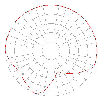 | ||||||||||||||||||
| Azimuth | Ratio | Azimuth | Ratio | Azimuth | Ratio | Azimuth | Ratio | ||||||||||||
| 0 | 1.000 | 10 | 1.000 | 20 | 1.000 | 30 | 1.000 | ||||||||||||
| 40 | 1.000 | 50 | 1.000 | 60 | 1.000 | 70 | 1.000 | ||||||||||||
| 80 | 1.000 | 90 | 1.000 | 100 | 1.000 | 110 | 1.000 | ||||||||||||
| 120 | 0.871 | 130 | 0.759 | 140 | 0.661 | 150 | 0.575 | ||||||||||||
| 160 | 0.501 | 165 | 0.501 | 170 | 0.562 | 180 | 0.708 | ||||||||||||
| 190 | 0.891 | 200 | 1.000 | 210 | 0.944 | 220 | 0.891 | ||||||||||||
| 230 | 0.841 | 240 | 0.841 | 250 | 0.891 | 260 | 0.944 | ||||||||||||
| 270 | 1.000 | 280 | 1.000 | 290 | 1.000 | 300 | 1.000 | ||||||||||||
| 310 | 1.000 | 320 | 1.000 | 330 | 1.000 | 340 | 1.000 | ||||||||||||
| 350 | 1.000 | ||||||||||||||||||
Structure Registration Number 1013913 Structure Type: TOWER Registered To: Goodrich Tower LLC Structure Address: 1.2 Mi N 59 E Of Int Hwy 15 & Kipp Rd Goodrich, MI County Name: Genesee County ASR Issued: 10/17/2018 Date Built: 01/01/1978 Site Elevation: 280.5 m (920 ft.) Structure Height: 261.8 m (859 ft.) Height Overall: 277.3 m (910 ft.) Overall Height AMSL: 557.8 m (1830 ft.) FAA Determination: 11/24/1978 FAA Study #: 78-GL-1074-OE Paint & Light FAA Chapters: A1, B, D, H HIGH INTENSITY WHITE LIGHTS 42-53-56.1 N 83-27-40.8 W (NAD 83) 42-53-56.0 N 83-27-41.0 W (Converted to NAD 27) |
172 N Cedar St Imlay City, MI 48444 Phone: 810-895-2040 Not-for-Profit | Title: President Date: 05/24/2022 Application Certifier MICHIGAN COMMUNITY RADIO Michigan Community Radio 172 N Cedar St Imlay City, MI 48444 Applicant EDWARD CZELADA Michigan Community Radio 3302 N Van Dyke Rd Imlay City, MI 48444 PRESIDENT | |||||||||||||||||