
FCCInfo.com
A Service of Cavell, Mertz & Associates, Inc.
(855) FCC-INFO
|
|
|
|
|
||||||||||||||||
|
|
Channel: 204C1 88.7 MHz Dover, Arkansas Service: FM - A full-service FM station or application. Facility ID: 767972 Fac. Service: FM Status: Construction Permit Application Accepted: 06/14/2022 Application Granted: 06/17/2022 File Number: -0000167774 CP Expires: 06/17/2025 Application Type: Non-Commercial Educational Amendment FCC Website Links: LMS Facility Details This Application Other Applications Other Applications in CDBS Including Superseded Applications Mailing Address Correspondence for Correspondence related to application -0000167774 Service Contour - Open Street Map or USGS Map (60 dBu) Service Contour - KML / Google Earth (60 dBu) Facility Type: NON-COMMERCIAL EDUC. FM Class: C1, A Zone II station; with 50kW-100kW ERP and a class contour distance 52km-72km Site Location: 35-29-41.2 N 92-54-00.0 W (NAD 83) Site Location: 35-29-40.9 N 92-53-59.4 W (Converted to NAD 27) Effective Radiated Power: 10 kW Antenna Center HAAT: 406 m (1332 ft.) Antenna Center AMSL: 700 m (2297 ft.) Antenna Center HAG: 84 m (276 ft.) Site Elevation: 615.7 m. (2020 ft.) Height Overall*: 97.5 m (320 ft.) (* As Filed In This Application, may differ from ASR Data, Below.) Directional Antenna Antenna Make/Model: None Antenna ID: 69-2019-08-06 Polarization: | ||||||||||||||||||
| Antenna Data for Antenna Id: 69-2019-08-06 FM File: -0000167774 None - Service: FM | 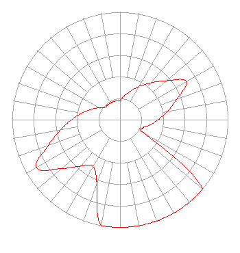 | ||||||||||||||||||
| Azimuth | Ratio | Azimuth | Ratio | Azimuth | Ratio | Azimuth | Ratio | ||||||||||||
| 0 | 0.178 | 10 | 0.224 | 20 | 0.282 | 30 | 0.355 | ||||||||||||
| 40 | 0.447 | 50 | 0.562 | 60 | 0.708 | 70 | 0.562 | ||||||||||||
| 80 | 0.447 | 90 | 0.355 | 100 | 0.282 | 110 | 0.224 | ||||||||||||
| 120 | 0.282 | 130 | 1.000 | 140 | 1.000 | 150 | 1.000 | ||||||||||||
| 160 | 1.000 | 170 | 1.000 | 180 | 1.000 | 190 | 1.000 | ||||||||||||
| 200 | 0.631 | 210 | 0.501 | 220 | 0.562 | 230 | 0.708 | ||||||||||||
| 240 | 0.891 | 250 | 0.708 | 260 | 0.562 | 270 | 0.447 | ||||||||||||
| 280 | 0.355 | 290 | 0.282 | 300 | 0.224 | 310 | 0.178 | ||||||||||||
| 320 | 0.178 | 330 | 0.178 | 340 | 0.178 | 350 | 0.178 | ||||||||||||
Structure Registration Number 1029997 Structure Type: LTOWER Registered To: Alltel Corporation Structure Address: 6726 Nfm 1301 White Mtn Rd (retta Site) Hector, AR County Name: Pope County ASR Issued: 02/05/2019 Date Built: 01/01/1995 Site Elevation: 615.7 m (2020 ft.) Structure Height: 91.4 m (300 ft.) Height Overall: 97.5 m (320 ft.) Overall Height AMSL: 713.2 m (2340 ft.) FAA Determination: 08/23/2016 FAA Study #: 2016-ASW-4876-OE FAA Circular #: 70/7460-1H Paint & Light FAA Chapters: 4, 8, 13 PRIOR STUDY 2004-ASW-1053-OE 35-29-41.2 N 92-54-00.0 W (NAD 83) 35-29-40.9 N 92-53-59.4 W (Converted to NAD 27) |
170 Weston St Imlay City, MI 48444 Phone: 586-996-5530 Not-for-Profit | Title: President Date: 06/14/2022 Application Certifier Full Potential Ministry 170 Weston St Imlay City, MI 48444 Applicant Edward T Czelada Etc Communications 3302 N Van Dyke Rd Imlay City, MI 48444 | |||||||||||||||||