
FCCInfo.com
A Service of Cavell, Mertz & Associates, Inc.
(855) FCC-INFO
|
|
K285HJ from 07/28/2017 K285HJ from 06/23/2017 K285HJ from 12/09/2013 |
|
|
||||||||||||||||
|
|
K285HJ Channel: 281D 104.1 MHz Dallas, Texas Service: FX - A translator or application for a translator. Facility ID: 144076 Fac. Service: FX Programming Delivery Method: Unspecified Status: Construction Permit Application Accepted: 06/28/2022 Application Granted: 07/27/2022 File Number: -0000194132 K285HJ CP Expires: 07/26/2025 Application Type: Minor Modification FCC Website Links: LMS Facility Details This Application Other K285HJ Applications Other K285HJ Applications in CDBS Including Superseded Applications Mailing Address Correspondence for K285HJ Correspondence related to application -0000194132 Service Contour - Open Street Map or USGS Map (60 dBu) Service Contour - KML / Google Earth (60 dBu) Facility Type: FM STATION Class: D, A Noncommercial educational operating with no more than 10W Site Location: 32-32-44.0 N 96-57-57.0 W (NAD 83) Site Location: 32-32-43.5 N 96-57-56.0 W (Converted to NAD 27) Effective Radiated Power: 0 kW Horiz. ; 0.23 kW Vert. Antenna Center HAAT: 0 m Antenna Center AMSL: 0 m Horiz.; 384.6 m Vert. Antenna Center HAG: 0 m Horiz.; 137 m Vert. Site Elevation: 247.6 m. (812 ft.) Height Overall*: 167.6 m (550 ft.) (* As Filed In This Application, may differ from ASR Data, Below.) Directional Antenna Antenna Make/Model: Scala CL-FM Antenna ID: 134895 Polarization: H
| ||||||||||||||||||
| Antenna Data for Antenna Id: 134895 K285HJ FX File: -0000194132 Scala - CL-FM Service: FX | 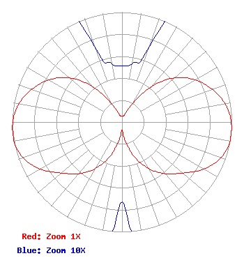 | ||||||||||||||||||
| Azimuth | Ratio | Azimuth | Ratio | Azimuth | Ratio | Azimuth | Ratio | ||||||||||||
| 0 | 0.051 | 10 | 0.054 | 20 | 0.073 | 30 | 0.204 | ||||||||||||
| 40 | 0.429 | 50 | 0.625 | 60 | 0.768 | 70 | 0.873 | ||||||||||||
| 80 | 0.954 | 90 | 0.994 | 100 | 1.000 | 110 | 0.956 | ||||||||||||
| 120 | 0.858 | 130 | 0.723 | 140 | 0.615 | 150 | 0.491 | ||||||||||||
| 160 | 0.340 | 170 | 0.175 | 180 | 0.073 | 190 | 0.175 | ||||||||||||
| 200 | 0.340 | 210 | 0.491 | 220 | 0.615 | 230 | 0.723 | ||||||||||||
| 240 | 0.858 | 250 | 0.956 | 260 | 1.000 | 270 | 0.994 | ||||||||||||
| 280 | 0.954 | 290 | 0.873 | 300 | 0.768 | 310 | 0.625 | ||||||||||||
| 320 | 0.429 | 330 | 0.204 | 340 | 0.073 | 350 | 0.054 | ||||||||||||
Structure Registration Number 1053763 Structure Type: GTOWER Registered To: RLJ Tower Leasing Inc Structure Address: 500 Edgefield Rd Midlothian, TX County Name: Ellis County ASR Issued: 08/07/2019 Date Built: 01/01/1984 Site Elevation: 247.6 m (812 ft.) Structure Height: 167.6 m (550 ft.) Height Overall: 167.6 m (550 ft.) Overall Height AMSL: 415.2 m (1362 ft.) FAA Determination: 08/14/1998 FAA Study #: 98-ASW-3203-OE FAA Circular #: 70/7460-1 Paint & Light FAA Chapters: 1, 3, 4, 13, 21 OM&L TO REMAIN RED LIGHTS/PAINT AS PER PREV FAA 84-ASW-3441-OE. 32-32-44.0 N 96-57-57.0 W (NAD 83) 32-32-43.5 N 96-57-56.0 W (Converted to NAD 27) |
6340 N. Eldridge Pkwy Suite N-201 Houston, TX 77041 Phone: 832-265-2561 Limited Liability Company | Title: Managing Member Date: 06/28/2022 Application Certifier We Serve Llc 6340 N. Eldridge Pkwy Suite N-201 Houston, TX 77041 Applicant Darryl K DeLawder Delawder Communications, Inc. P. O. Box 1095 Ashburn, VA 20146-1095 President Dan J Alpert The Law Office Of Dan J. Alpert 2120 21st Rd. N Arlington, VA 22201 Legal Counsel | |||||||||||||||||