
FCCInfo.com
A Service of Cavell, Mertz & Associates, Inc.
(855) FCC-INFO
|
|
W240EK from 08/15/2012 W240EK from 09/09/1997 W240EK from 02/04/1997 |
|
|
||||||||||||||||
|
|
W240EK Channel: 240D 95.9 MHz Athens, Georgia Service: FX - A translator or application for a translator. Facility ID: 85699 Fac. Service: FX Programming Delivery Method: Unspecified Status: License Application Accepted: 06/20/2022 Application Granted: 07/07/2022 File Number: -0000193529 License Expires: 04/01/2028 Application Type: License To Cover FCC Website Links: LMS Facility Details This Application Other W240EK Applications Other W240EK Applications in CDBS Including Superseded Applications Mailing Address Correspondence for W240EK Correspondence related to application -0000193529 Service Contour - Open Street Map or USGS Map (60 dBu) Service Contour - KML / Google Earth (60 dBu) Facility Type: FM STATION Class: D, A Noncommercial educational operating with no more than 10W Site Location: 34-05-01.1 N 83-19-19.3 W (NAD 83) Site Location: 34-05-00.7 N 83-19-19.7 W (Converted to NAD 27) Effective Radiated Power: 0.1 kW Transmitter Output Power: 0.3 kW Antenna Center HAAT: 89 m Horiz.; 0 m Vert. Antenna Center AMSL: 604.8 m (1984 ft.) Antenna Center HAG: 338.9 m (1112 ft.) Site Elevation: 265.9 m. (872 ft.) Height Overall*: 362.5 m (1189 ft.) (* As Filed In This Application, may differ from ASR Data, Below.) Directional Antenna Antenna Make/Model: Scala HDCA5 Antenna ID: 105542 Polarization: H
| ||||||||||||||||||
| Antenna Data for Antenna Id: 105542 W240EK FX File: -0000193529 Scala - HDCA5 Service: FX | 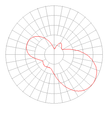 | ||||||||||||||||||
| Azimuth | Ratio | Azimuth | Ratio | Azimuth | Ratio | Azimuth | Ratio | ||||||||||||
| 0 | 0.119 | 10 | 0.129 | 20 | 0.207 | 30 | 0.270 | ||||||||||||
| 40 | 0.245 | 50 | 0.202 | 60 | 0.202 | 70 | 0.305 | ||||||||||||
| 80 | 0.472 | 90 | 0.660 | 100 | 0.817 | 110 | 0.932 | ||||||||||||
| 120 | 0.987 | 130 | 0.995 | 140 | 0.956 | 150 | 0.858 | ||||||||||||
| 160 | 0.707 | 170 | 0.540 | 180 | 0.399 | 190 | 0.309 | ||||||||||||
| 200 | 0.287 | 210 | 0.295 | 220 | 0.303 | 230 | 0.290 | ||||||||||||
| 240 | 0.271 | 250 | 0.322 | 260 | 0.418 | 270 | 0.518 | ||||||||||||
| 280 | 0.572 | 290 | 0.593 | 300 | 0.590 | 310 | 0.551 | ||||||||||||
| 320 | 0.479 | 330 | 0.384 | 340 | 0.277 | 350 | 0.181 | ||||||||||||
Structure Registration Number 1020944 Structure Type: TOWER Registered To: Global Tower, LLC. through American Towers, LLC Structure Address: 7200 Neese-commerce Road Neese, GA County Name: Madison County ASR Issued: 08/29/2014 Date Built: 09/12/2006 Site Elevation: 265.9 m (872 ft.) Structure Height: 341.5 m (1120 ft.) Height Overall: 362.5 m (1189 ft.) Overall Height AMSL: 628.4 m (2062 ft.) FAA Determination: 09/12/2006 FAA Study #: 2006-ASO-4473-OE Paint & Light FAA Chapters: B, E, H Continue As Is OM&L = 24-HR HI-STROBES 34-05-01.1 N 83-19-19.3 W (NAD 83) 34-05-00.7 N 83-19-19.7 W (Converted to NAD 27) |
1579f Monroe Drive Suite 907 Atlanta, GA 30324 Phone: 404-874-6584 Limited Liability Company | Title: Managing Member Date: 06/20/2022 Application Certifier MOPATCHES, LLC Mopatches, Llc 1579f Monroe Drive Suite 907 Atlanta, GA 30324 Applicant KRIS KENDRICK Oconee River Broadcasting, Llc 259 Turner St Royston, GA 30662 | |||||||||||||||||