
FCCInfo.com
A Service of Cavell, Mertz & Associates, Inc.
(855) FCC-INFO
|
|
W269CF from 10/15/2007 W269CF from 07/11/2007 W269CF from 05/01/2007 W269CF from 02/08/2007 W269CF from 08/09/2006 W269CF from 06/21/2004 |
|
|
||||||||||||||||
|
|
W269CF Channel: 269D 101.7 MHz Scranton, Pennsylvania Service: FX - A translator or application for a translator. Facility ID: 157680 Fac. Service: FX Programming Delivery Method: Unspecified Status: License Application Accepted: 06/24/2022 Application Granted: 07/07/2022 File Number: -0000193877 License Expires: 08/01/2022 Application Type: Minor Modification FCC Website Links: LMS Facility Details This Application Other W269CF Applications Other W269CF Applications in CDBS Including Superseded Applications Mailing Address Correspondence for W269CF Correspondence related to application -0000193877 Service Contour - Open Street Map or USGS Map (60 dBu) Service Contour - KML / Google Earth (60 dBu) Facility Type: FM STATION Class: D, A Noncommercial educational operating with no more than 10W Site Location: 41-25-36.0 N 75-44-51.0 W (NAD 83) Site Location: 41-25-35.7 N 75-44-52.3 W (Converted to NAD 27) Effective Radiated Power: 0.057 kW Transmitter Output Power: 0.014 kW Antenna Center HAAT: 224.5 m (737 ft.) Antenna Center AMSL: 693 m (2274 ft.) Antenna Center HAG: 20.9 m (69 ft.) Site Elevation: 672.1 m. (2205 ft.) Height Overall*: 159.5 m (523 ft.) (* As Filed In This Application, may differ from ASR Data, Below.) Directional Antenna Antenna Make/Model: SCALA CA2-Slant 45 @ 343 & 105 Antenna ID: 118082 Polarization: H
| ||||||||||||||||||
| Antenna Data for Antenna Id: 118082 W269CF FX File: -0000193877 SCALA - CA2-Slant 45 @ 343 & 105 Service: FX | 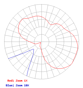 | ||||||||||||||||||
| Azimuth | Ratio | Azimuth | Ratio | Azimuth | Ratio | Azimuth | Ratio | ||||||||||||
| 0 | 0.664 | 10 | 0.613 | 20 | 0.544 | 30 | 0.520 | ||||||||||||
| 40 | 0.623 | 50 | 0.680 | 60 | 0.699 | 70 | 0.781 | ||||||||||||
| 80 | 0.877 | 90 | 0.942 | 100 | 0.982 | 110 | 0.983 | ||||||||||||
| 120 | 0.988 | 125 | 1.000 | 130 | 0.986 | 140 | 0.919 | ||||||||||||
| 150 | 0.827 | 160 | 0.682 | 170 | 0.474 | 180 | 0.242 | ||||||||||||
| 190 | 0.162 | 200 | 0.124 | 210 | 0.051 | 220 | 0.033 | ||||||||||||
| 230 | 0.033 | 240 | 0.072 | 250 | 0.180 | 260 | 0.227 | ||||||||||||
| 270 | 0.323 | 280 | 0.492 | 290 | 0.631 | 300 | 0.718 | ||||||||||||
| 310 | 0.764 | 320 | 0.783 | 330 | 0.719 | 340 | 0.702 | ||||||||||||
| 350 | 0.696 | ||||||||||||||||||
Structure Registration Number 1027163 Structure Type: GTOWER Registered To: Subcarrier Communications, Inc. Structure Address: Bald Mountain Ransom Twp Scranton, PA County Name: Lackawanna County ASR Issued: 01/17/2018 Date Built: 01/01/1988 Site Elevation: 672.1 m (2205 ft.) Structure Height: 158.3 m (519 ft.) Height Overall: 159.5 m (523 ft.) Overall Height AMSL: 831.6 m (2728 ft.) FAA Determination: 06/05/2017 FAA Study #: 2017-AEA-5892-OE FAA Circular #: 70/7460-1L Paint & Light FAA Chapters: 3, 4, 5, 12 PRIOR STUDY 1988-AEA-1036-OE 41-25-36.0 N 75-44-51.0 W (NAD 83) 41-25-35.7 N 75-44-52.3 W (Converted to NAD 27) |
115 West Main Street Frankfort, KY 40601 Phone: 502-875-1130 Limited Liability Company | Title: Sole Proprietor Date: 06/24/2022 Application Certifier P.o. Box 20155 Scranton, PA 18502 Applicant Kevin M Fitzgerald Kevin Fitzgerald Engineering P.o. Box 20155 Scranton, PA 18502 CHIEF ENGINEER Kevin M Fitzgerald Kevin Fitzgerald Engineering P.o. Box 20155 Scranton, PA 18502 | |||||||||||||||||