
FCCInfo.com
A Service of Cavell, Mertz & Associates, Inc.
(855) FCC-INFO
|
|
W256EA from 01/15/2014 |
|
|
||||||||||||||||
|
|
W256EA Channel: 256D 99.1 MHz Birmingham, Michigan Service: FX - A translator or application for a translator. Facility ID: 157285 Fac. Service: FX Programming Delivery Method: Unspecified Status: License Application Accepted: 07/08/2022 Application Granted: 04/27/2023 File Number: -0000194669 License Expires: 10/01/2028 Application Type: License To Cover FCC Website Links: LMS Facility Details This Application Other W256EA Applications Other W256EA Applications in CDBS Including Superseded Applications Mailing Address Correspondence for W256EA Correspondence related to application -0000194669 Service Contour - Open Street Map or USGS Map (60 dBu) Service Contour - KML / Google Earth (60 dBu) Facility Type: NON-COMMERCIAL EDUC. FM Class: D, A Noncommercial educational operating with no more than 10W Site Location: 42-38-55.0 N 83-04-31.0 W (NAD 83) Site Location: 42-38-54.9 N 83-04-31.3 W (Converted to NAD 27) Effective Radiated Power: 0.25 kW Transmitter Output Power: 0.05 kW Antenna Center HAAT: 0 m Antenna Center AMSL: 331.4 m (1087 ft.) Antenna Center HAG: 118 m (387 ft.) Site Elevation: 213.4 m. (700 ft.) Height Overall*: 128 m (420 ft.) (* As Filed In This Application, may differ from ASR Data, Below.) Directional Antenna Antenna Make/Model: ETC FM-2CP-DA Antenna ID: 1007185 Polarization: H
| ||||||||||||||||||
| Antenna Data for Antenna Id: 1007185 W256EA FX File: -0000194669 ETC - FM-2CP-DA Service: FX | 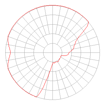 | ||||||||||||||||||
| Azimuth | Ratio | Azimuth | Ratio | Azimuth | Ratio | Azimuth | Ratio | ||||||||||||
| 0 | 1.000 | 10 | 1.000 | 20 | 1.000 | 30 | 1.000 | ||||||||||||
| 40 | 1.000 | 50 | 1.000 | 60 | 0.631 | 70 | 0.501 | ||||||||||||
| 80 | 0.447 | 90 | 0.355 | 100 | 0.316 | 110 | 0.200 | ||||||||||||
| 120 | 0.200 | 130 | 0.200 | 140 | 0.211 | 150 | 0.224 | ||||||||||||
| 160 | 0.211 | 170 | 0.224 | 180 | 0.237 | 190 | 0.487 | ||||||||||||
| 200 | 1.000 | 210 | 1.000 | 220 | 1.000 | 230 | 1.000 | ||||||||||||
| 240 | 1.000 | 250 | 1.000 | 260 | 0.944 | 270 | 0.891 | ||||||||||||
| 280 | 0.944 | 290 | 1.000 | 300 | 1.000 | 310 | 1.000 | ||||||||||||
| 320 | 1.000 | 330 | 1.000 | 340 | 1.000 | 350 | 1.000 | ||||||||||||
Structure Registration Number 1064760 Structure Type: TOWER Registered To: Peake Holdings, LLC Structure Address: 48181 Ryan Rd Shelby Township, MI County Name: Macomb County ASR Issued: 09/02/2009 Date Built: 09/01/1980 Site Elevation: 213.4 m (700 ft.) Structure Height: 118.9 m (390 ft.) Height Overall: 128 m (420 ft.) Overall Height AMSL: 341.4 m (1120 ft.) FAA Determination: 01/01/1984 FAA Study #: 84-AGL-2491-OE Paint & Light FAA Chapters: 1, 3, 12, 21 RED LIGHTS/PAINT 42-38-55.0 N 83-04-31.0 W (NAD 83) 42-38-54.9 N 83-04-31.3 W (Converted to NAD 27) |
172 N Cedar St Imlay City, MI 48444 Phone: 810-895-2040 Not-for-Profit | Title: President Date: 07/08/2022 Application Certifier MICHIGAN COMMUNITY RADIO Michigan Community Radio 172 N Cedar St Imlay City, MI 48444 Applicant Edward Czelada Michigan Community Radio 172 N Cedar St Imlay City, MI 48444 EDWARD CZELADA Michigan Community Radio 3302 North Van Dyke Rd Imlay City, MI 48444 PRESIDENT | |||||||||||||||||