
FCCInfo.com
A Service of Cavell, Mertz & Associates, Inc.
(855) FCC-INFO
|
|
WBQF from 07/31/2017 WBQF from 07/24/2017 WBQF from 07/08/2009 |
|
|
||||||||||||||||
|
|
WBQF Channel: 219C3 91.7 MHz Fryeburg, Maine Service: FM - A full-service FM station or application. Facility ID: 174153 Fac. Service: FM Status: License Application Accepted: 07/14/2022 Application Granted: 07/25/2022 File Number: -0000194981 License Expires: 04/01/2030 Application Type: License To Cover FCC Website Links: LMS Facility Details This Application Other WBQF Applications Other WBQF Applications in CDBS Including Superseded Applications Mailing Address Correspondence for WBQF Correspondence related to application -0000194981 Service Contour - Open Street Map or USGS Map (60 dBu) Service Contour - KML / Google Earth (60 dBu) Public Inspection Files Facility Type: NON-COMMERCIAL EDUC. FM Class: C3, A Zone II station; with 6kW-25kW ERP and a class contour distance 28km-39km Site Location: 43-51-30.0 N 70-42-39.0 W (NAD 83) Site Location: 43-51-29.7 N 70-42-40.8 W (Converted to NAD 27) Effective Radiated Power: 0.25 kW Transmitter Output Power: 0.196 kW Antenna Center HAAT: 551 m (1808 ft.) Antenna Center AMSL: 695 m (2280 ft.) Antenna Center HAG: 321 m (1053 ft.) Site Elevation: 374.4 m. (1228 ft.) Height Overall*: 397.7 m (1305 ft.) (* As Filed In This Application, may differ from ASR Data, Below.) Directional Antenna Antenna Make/Model: Shively 6025-4/1 Antenna ID: 97091 Polarization: | ||||||||||||||||||
| Antenna Data for Antenna Id: 97091 WBQF FM File: -0000194981 Shively - 6025-4/1 Service: FM | 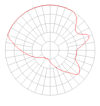 | ||||||||||||||||||
| Azimuth | Ratio | Azimuth | Ratio | Azimuth | Ratio | Azimuth | Ratio | ||||||||||||
| 0 | 1.000 | 10 | 1.000 | 20 | 1.000 | 30 | 1.000 | ||||||||||||
| 40 | 0.923 | 50 | 0.733 | 60 | 0.733 | 70 | 0.920 | ||||||||||||
| 80 | 0.750 | 90 | 0.596 | 100 | 0.596 | 110 | 0.596 | ||||||||||||
| 120 | 0.750 | 130 | 0.822 | 140 | 0.653 | 150 | 0.519 | ||||||||||||
| 160 | 0.412 | 170 | 0.327 | 180 | 0.260 | 190 | 0.207 | ||||||||||||
| 200 | 0.207 | 210 | 0.207 | 220 | 0.207 | 230 | 0.260 | ||||||||||||
| 240 | 0.327 | 250 | 0.412 | 260 | 0.519 | 270 | 0.653 | ||||||||||||
| 280 | 0.822 | 290 | 1.000 | 300 | 1.000 | 310 | 1.000 | ||||||||||||
| 320 | 1.000 | 330 | 1.000 | 340 | 1.000 | 350 | 1.000 | ||||||||||||
Structure Registration Number 1055705 Structure Type: TOWER Registered To: Pacific and Southern, LLC Structure Address: Tower Rd Winn Mt East Sebago, ME County Name: Cumberland County ASR Issued: 02/13/2019 Date Built: 01/01/1984 Site Elevation: 374.4 m (1228 ft.) Structure Height: 397.7 m (1305 ft.) Height Overall: 397.7 m (1305 ft.) Overall Height AMSL: 772.1 m (2533 ft.) Paint & Light FAA Chapters: B, E, H 43-51-30.0 N 70-42-39.0 W (NAD 83) 43-51-29.7 N 70-42-40.8 W (Converted to NAD 27) |
63 Texas Ave. Bangor, ME 04401 Phone: 207-404-5118 Not-for-Profit | Title: Chief Technology Officer Date: 07/14/2022 Application Certifier Maine Public Broadcasting Corporation 63 Texas Ave. Bangor, ME 04401 Applicant Gray Frierson Haertig Gray Frierson Haertig & Assoc. 4646 S.w. Council Crest Drive Portland, OR 97239 Engineering Counsel Barry S. Persh Gray Miller Persh Llp 2233 Wisconsin Ave., Nw Suite 226 Washington, DC 20007 | |||||||||||||||||