
FCCInfo.com
A Service of Cavell, Mertz & Associates, Inc.
(855) FCC-INFO
|
|
|
|
|
||||||||||||||||
|
|
W283DO Channel: 283D 104.5 MHz Torrington, Connecticut Service: FX - A translator or application for a translator. Facility ID: 202639 Fac. Service: FX Programming Delivery Method: Unspecified Status: License Application Accepted: 08/24/2022 Application Granted: 09/15/2022 File Number: -0000198253 License Expires: 04/01/2030 Application Type: License To Cover FCC Website Links: LMS Facility Details This Application Other W283DO Applications Other W283DO Applications in CDBS Including Superseded Applications Mailing Address Correspondence for W283DO Correspondence related to application -0000198253 Service Contour - Open Street Map or USGS Map (60 dBu) Service Contour - KML / Google Earth (60 dBu) Facility Type: FM STATION Class: D, A Noncommercial educational operating with no more than 10W Site Location: 41-45-31.0 N 73-03-07.0 W (NAD 83) Site Location: 41-45-30.6 N 73-03-08.6 W (Converted to NAD 27) Effective Radiated Power: 0.25 kW Antenna Center HAAT: 0 m Antenna Center AMSL: 355.1 m (1165 ft.) Antenna Center HAG: 96 m (315 ft.) Site Elevation: 259.1 m. (850 ft.) Height Overall*: 99 m (325 ft.) (* As Filed In This Application, may differ from ASR Data, Below.) Directional Antenna Antenna Make/Model: Dielectric DCRH3B50RD Antenna ID: 135110 Polarization: H
| ||||||||||||||||||
| Antenna Data for Antenna Id: 135110 W283DO FX File: -0000198253 Dielectric - DCRH3B50RD Service: FX | 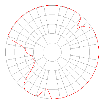 | ||||||||||||||||||
| Azimuth | Ratio | Azimuth | Ratio | Azimuth | Ratio | Azimuth | Ratio | ||||||||||||
| 0 | 1.000 | 10 | 1.000 | 20 | 1.000 | 30 | 1.000 | ||||||||||||
| 40 | 0.950 | 46 | 0.740 | 50 | 0.850 | 60 | 1.000 | ||||||||||||
| 70 | 1.000 | 80 | 1.000 | 90 | 1.000 | 100 | 1.000 | ||||||||||||
| 110 | 1.000 | 120 | 1.000 | 130 | 1.000 | 140 | 1.000 | ||||||||||||
| 150 | 1.000 | 160 | 1.000 | 170 | 1.000 | 180 | 1.000 | ||||||||||||
| 185 | 0.850 | 189 | 0.780 | 190 | 0.814 | 200 | 1.000 | ||||||||||||
| 210 | 1.000 | 220 | 0.930 | 230 | 0.570 | 240 | 0.420 | ||||||||||||
| 247 | 0.430 | 250 | 0.439 | 255 | 0.420 | 260 | 0.455 | ||||||||||||
| 270 | 0.550 | 280 | 0.620 | 290 | 1.000 | 300 | 1.000 | ||||||||||||
| 310 | 1.000 | 320 | 1.000 | 330 | 1.000 | 340 | 1.000 | ||||||||||||
| 350 | 1.000 | ||||||||||||||||||
Structure Registration Number 1045023 Structure Type: 3TA1 Registered To: Red Wolf Broadcasting Corporation Structure Address: Twr 1 - 64 Hungerford Lane Harwinton, CT County Name: Litchfield County ASR Issued: 10/03/2023 Date Built: 01/01/1963 Site Elevation: 259.1 m (850 ft.) Structure Height: 99 m (325 ft.) Height Overall: 99 m (325 ft.) Overall Height AMSL: 358.1 m (1175 ft.) FAA Determination: 09/18/1963 FAA Study #: 1-OE-3961 Paint & Light FAA Chapters: 1, 3, 12, 21 RED LIGHTS/PAINT 41-45-31.0 N 73-03-07.0 W (NAD 83) 41-45-30.6 N 73-03-08.6 W (Converted to NAD 27) |
758 Colonel Ledyard Highway P.o. Box 357 Ledyard, CT 06339 Phone: 860-464-1065 Corporation | Title: President Date: 08/24/2022 Application Certifier RED WOLF BROADCASTING CORPORATION Red Wolf Broadcasting Corporation 758 Colonel Ledyard Highway P.o. Box 357 Ledyard, CT 06339 Applicant William Jeffrey Reynolds Du Treil, Lundin & Rackley, Inc. 5212 Station Way Sarasota, FL 34233 TECHNICAL CONSULTANT Scott Woodworth Edinger Associates 1725 I Street Nw Suite 300 Washington, DC 20006 | |||||||||||||||||